
Bellport Bay
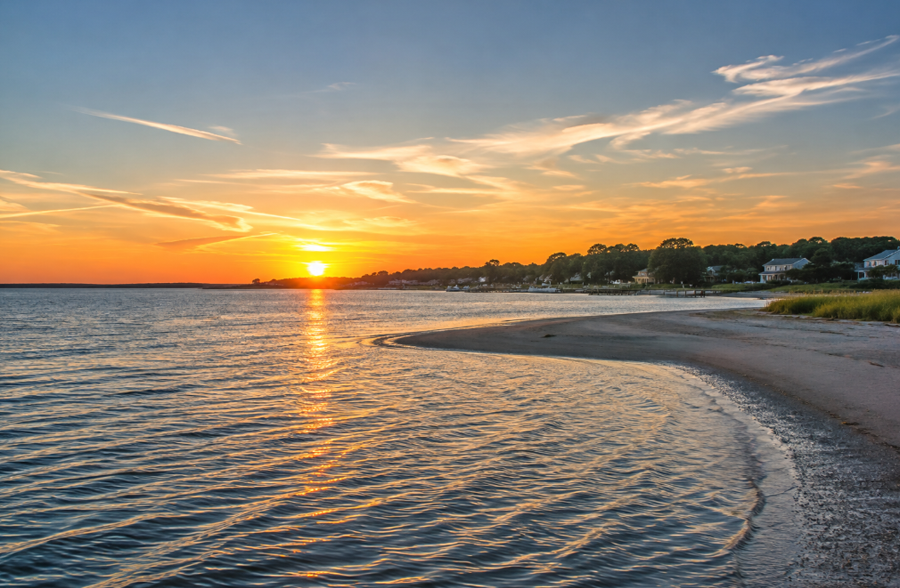
Bellport Bay is a shallow coastal bay along the South Shore of Suffolk County on Long Island, New York. Centered offshore from Bellport and the Brookhaven area, it forms the eastern portion of Great South Bay, the extensive lagoon separating mainland Long Island from Fire Island. Bellport Bay is bordered by communities including East Patchogue, Bellport, Brookhaven, Mastic Beach and Shirley, while the protected barrier island of Fire Island National Seashore lies across the bay to the south. The Town of Brookhaven identifies Bellport Bay as part of eastern Great South Bay.
Like much of the Great South Bay system, Bellport Bay consists of broad stretches of relatively shallow water surrounded by tidal wetlands, creeks, coves and salt-marsh habitat. It forms part of the larger network of bays, harbors, inlets and waterways extending behind Long Island’s Atlantic barrier beaches. To the west, the waters continue toward the central portions of Great South Bay and Patchogue, while the eastern bay system narrows toward Narrow Bay and ultimately Moriches Bay. National Park Service mapping identifies Bellport Bay between Great South Bay to the west and Narrow Bay farther east.
Geography
Bellport Bay occupies the protected waters immediately south of Bellport and neighboring mainland communities in the Town of Brookhaven. Although commonly identified as a bay in its own right, it is geographically part of the eastern end of Great South Bay.
The mainland shoreline around the bay includes residential waterfront areas, tidal creeks, marinas, docks and preserved wetlands. Bellport sits prominently along the northern shore, with East Patchogue and Patchogue farther west and Brookhaven, Mastic Beach and Shirley extending eastward along the South Shore.
Across the water, Fire Island creates a long barrier between Bellport Bay and the Atlantic Ocean. Much of the barrier island opposite the bay falls within Fire Island National Seashore, whose federally protected boundary extends thousands of feet northward into Great South Bay and includes marine waters, wetlands, islands and sand flats.
Bellport Bay and Great South Bay
Bellport Bay is not separated from Great South Bay by a major land barrier. Instead, it represents a named eastern section of the larger estuary.
Great South Bay stretches for miles behind Fire Island, with different portions historically receiving local names based on nearby communities and geographic features. Bellport Bay marks the portion centered around Bellport and the eastern Brookhaven shoreline.
Farther west are the waters associated with Patchogue and other central Great South Bay communities. Moving east, Bellport Bay eventually transitions toward narrower waterways leading toward Moriches Bay.
Official state and federal mapping shows Bellport Bay as one of the principal named sections within the eastern Great South Bay system.
Fire Island
Fire Island forms the southern boundary of Bellport Bay and protects the bay from the direct wave energy of the Atlantic Ocean.
The barrier island in this area is largely protected within Fire Island National Seashore. The eastern portion includes the Otis Pike Fire Island High Dune Wilderness, a seven-mile undeveloped stretch of barrier island containing dunes, maritime vegetation and coastal habitat.
The separation created by Fire Island gives Bellport Bay the sheltered estuarine character typical of Long Island’s South Shore bays, with relatively protected waters on the north side of the barrier island and ocean beaches immediately to the south.
The Wilderness Breach and Old Inlet
Bellport Bay received significant scientific attention after Hurricane Sandy crossed Long Island in October 2012 and opened a breach through the wilderness portion of Fire Island near an area historically known as Old Inlet.
The opening created a direct exchange between the Atlantic Ocean and the eastern Great South Bay system. National Park Service monitoring found that the breach altered circulation patterns in Bellport Bay and neighboring waters, with modeling showing water generally moving westward from Bellport Bay through the bay system toward Fire Island Inlet.
Researchers also observed localized improvements in water clarity and reductions in nitrogen levels near Bellport Bay and portions of eastern Great South Bay following the breach. The National Park Service reported increased species diversity and improvements in water quality near the opening, although nitrogen pollution from septic systems, development and fertilizers remained a broader regional concern.
The breach became an important natural laboratory for studying how ocean exchange affects salinity, water quality, tides, seagrass and marine life within a barrier-island estuary.
Bellport and the Waterfront
The incorporated Village of Bellport is the community most closely identified with Bellport Bay.
Its waterfront faces south across the bay toward Fire Island, giving the village a longstanding connection to boating, sailing, fishing and other maritime activities.
The surrounding shoreline includes private docks, marinas, tidal creeks and wetlands. Nearby Brookhaven also has a strong relationship with Great South Bay, where boating and fishing are prominent recreational activities.
To the west, East Patchogue and Patchogue connect Bellport Bay with the broader central Great South Bay waterfront. Eastward, the shoreline continues through the Mastic Beach and Shirley areas.
Boating and Sailing
Boating is one of the defining recreational activities on Bellport Bay.
The bay’s protected position behind Fire Island provides extensive waters for recreational boats, sailboats and other small craft. Bellport Bay Yacht Club and other waterfront facilities reflect the area’s longstanding boating culture, while channels through the broader Great South Bay system allow vessels to travel west toward Patchogue or east toward the Moriches Bay region. A Town of Brookhaven waterfront advisory committee includes representation from Bellport Bay Yacht Club, reflecting the bay’s continuing role in local waterfront planning and recreation.
The surrounding South Shore also contains numerous marinas, while sailing remains a traditional use of the protected waters throughout Great South Bay.
Shallow depths, shoaling, submerged vegetation and changing local conditions mean boaters should follow marked channels and current navigation information.
Fishing
Fishing has long been associated with Bellport Bay and the surrounding Great South Bay ecosystem.
Protected bay waters provide habitat for numerous marine species, while anglers also have access to the ocean side of Fire Island and nearby locations such as Smith Point County Park.
The Otis Pike Fire Island High Dune Wilderness, opposite the Bellport Bay area, is used by anglers targeting species including striped bass, bluefish and winter flounder.
Fishing opportunities vary seasonally, and recreational anglers can also explore where to fish, fishing piers and fishing charters around Long Island.
Shellfish
Shellfish have historically been an important part of Bellport Bay and the larger Great South Bay ecosystem.
Hard clams occur throughout many Long Island bays, and New York State records specifically identify Bellport Bay among South Shore waters where hard clam harvest has occurred.
Clams are ecologically important because they filter suspended material from the water while feeding. The health of shellfish populations is consequently connected with broader issues involving water quality, habitat and nutrient levels throughout Great South Bay.
Shellfish harvesting is regulated, and open or closed harvesting areas can change according to water-quality conditions.
Eelgrass and Marine Habitat
Bellport Bay also contains important submerged aquatic habitat.
Eelgrass provides shelter and nursery habitat for fish and other marine organisms while helping stabilize bottom sediments. The Town of Brookhaven and Cornell Cooperative Extension have conducted eelgrass restoration work in Bellport Bay, including experimental plantings intended to determine where eelgrass could successfully reestablish within eastern Great South Bay.
Changes following the Fire Island wilderness breach also provided researchers with an opportunity to study relationships between ocean circulation, water clarity and seagrass. National Park Service observations found that seagrass increased in some isolated areas of Great South Bay after changes associated with the breach.
Salt Marshes and Coastal Wetlands
The Bellport Bay shoreline includes tidal wetlands, marshes and shallow coastal habitat characteristic of the South Shore estuary system.
These wetlands provide habitat for birds, fish and other wildlife while creating a transition between developed mainland communities and open bay waters.
The protected areas of Fire Island National Seashore add substantial undeveloped shoreline and marine habitat to the southern side of the bay. The National Seashore encompasses marine waters, sand flats, wetlands and islands in addition to the better-known ocean beaches and dunes.
The combination of marshes, open water and barrier-island habitat also makes the region useful for birdwatching and nature observation.
Kayaking and Paddleboarding
The protected waters and sheltered shoreline around portions of Bellport Bay can provide opportunities for kayaking and paddleboarding.
Paddlers can explore areas near the mainland shoreline, tidal creeks and marshes while viewing Bellport Bay from a perspective different from that available from shore.
Wind, tides, boat traffic and rapidly changing weather can create challenging conditions on the open bay, particularly farther from protected shoreline areas.
Environmental Challenges
Bellport Bay shares many of the environmental challenges affecting Great South Bay and other developed South Shore estuaries.
Nitrogen entering coastal waters from septic systems, fertilizers and developed areas has contributed to water-quality problems throughout the Great South Bay ecosystem. Excess nutrients can encourage harmful algal blooms and affect seagrass, shellfish and other marine organisms.
Bellport Bay has received particular attention because changes in water circulation following the Fire Island wilderness breach provided researchers with unusual opportunities to compare water quality before and after increased ocean exchange.
Eelgrass restoration, shellfish conservation, wastewater improvements and broader watershed management efforts are among the strategies used throughout the region to improve the health of South Shore estuaries.
Bellport Bay and Fire Island National Seashore
The relationship between Bellport Bay and Fire Island National Seashore is particularly important because the National Seashore protects much of the barrier island directly opposite the bay.
Unlike the heavily developed mainland shoreline, this portion of Fire Island contains large areas of undeveloped dunes, beaches, wetlands and maritime habitat.
The federally protected boundary extends into Great South Bay itself, meaning portions of the marine environment south of Bellport Bay are part of the National Seashore rather than merely adjacent to it.
Farther east, Smith Point County Park provides public access to the barrier island near the eastern end of the Great South Bay system and the transition toward Narrow Bay and Moriches Bay.
Bellport Bay within Long Island’s South Shore Estuary
Bellport Bay occupies an important geographic position within the chain of protected waters running behind Long Island’s Atlantic barrier islands.
It forms the eastern extent of Great South Bay, with central Great South Bay and the Patchogue waterfront to the west. To the east, the bay system narrows before reaching the Moriches Bay region. To the south, Fire Island separates these protected waters from the Atlantic Ocean.
This combination of mainland waterfront communities, shallow estuarine waters, salt marshes and protected barrier-island habitat makes Bellport Bay an important component of Long Island’s larger bays, harbors, inlets and waterways system.
Bellport Bay
Key Facts & Details
Bellport Bay forms one of the most distinctive sections of eastern Great South Bay, linking the historic waterfront community of Bellport with the protected shores of Fire Island National Seashore. Surrounded by the coastal communities of the Town of Brookhaven and separated from the Atlantic Ocean by Fire Island, the bay remains an important setting for boating, fishing, wildlife habitat and the continuing study and restoration of Long Island’s South Shore estuaries.
Are you ready for fall on Long Island? Check out these local seasonal guides:
🍎 Apple Picking 🍓 Strawberry Picking 🎃 Pumpkin Picking 👻 Haunted Houses 🍂 Farm Festivals
