
Long Island’s Four Counties: Map and Quick Guide
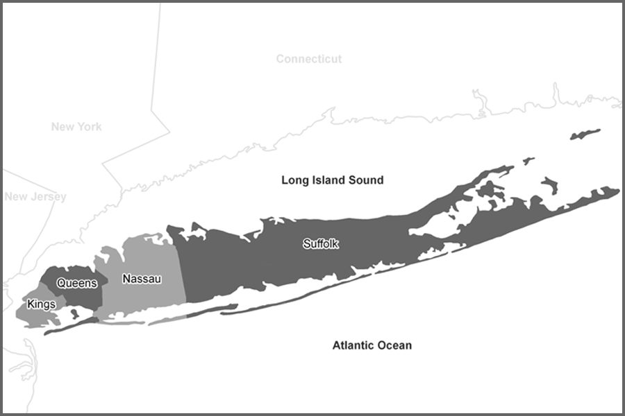
Long Island is geographically divided into four counties: Kings County, better known as Brooklyn; Queens County; Nassau County; and Suffolk County. In everyday conversation, many people use “Long Island” to refer only to Nassau and Suffolk, but geographically, Brooklyn and Queens are also part of the island. This guide uses the broader four-county view.
Brooklyn, which is coterminous with Kings County, occupies the island’s western tip and forms one of New York City’s five boroughs. It adds a dense urban layer to Long Island’s story, with landmark sites, major cultural institutions, distinctive neighborhoods, waterfront parks, and a long history tied to the growth of New York Harbor.
Queens, the eastern neighbor of Brooklyn on western Long Island, is also both a New York City borough and a county. Known for its cultural diversity, Queens includes major green spaces, museums, sports venues, airports, rail connections, and neighborhoods that link Long Island with the rest of New York City.
Nassau County begins immediately east of Queens and is the first of Long Island’s two suburban counties outside New York City. Visitors will find downtown villages, established residential communities, beaches, waterfront areas, historic estates, parks, colleges, and shopping districts. Its central location also makes Nassau a common base for day trips across the island.
Suffolk County covers the eastern half of Long Island and is the island’s largest county by land area. From the South Shore’s beaches to the North Shore’s harbors, and from the farms and wineries of the North Fork to the Hamptons and other East End destinations, Suffolk offers some of the region’s best-known coastal, rural, and resort landscapes.
Long Island Counties at a Glance
| County | Common Name or Area | Government Context | General Location |
|---|---|---|---|
| Kings County | Brooklyn | New York City borough and county | Western end of Long Island |
| Queens County | Queens | New York City borough and county | Western Long Island, east of Brooklyn |
| Nassau County | Nassau | Suburban county outside New York City | Central-western Long Island, east of Queens |
| Suffolk County | Suffolk | Suburban and rural county outside New York City | Eastern Long Island, including the East End |
For travelers, the county split helps explain why Long Island can feel so varied. Brooklyn and Queens function within New York City’s borough system, while Nassau and Suffolk are organized around towns, villages, cities, hamlets, and county government. That difference shapes everything from local services and downtown identity to beaches, park access, school districts, postal names, and neighborhood boundaries.
How Nassau and Suffolk Are Organized
The town, village, and hamlet structure most visitors associate with Long Island applies mainly to Nassau and Suffolk. Nassau County has three towns and two cities, while Suffolk County has ten towns and no incorporated cities. Villages are incorporated municipalities within towns, while hamlets are unincorporated communities served by town or county government.
| County | Towns | Cities | Notes |
|---|---|---|---|
| Nassau County | Hempstead, North Hempstead, Oyster Bay | Glen Cove, Long Beach | Nassau includes towns, incorporated villages, hamlets, and two cities. |
| Suffolk County | Babylon, Brookhaven, East Hampton, Huntington, Islip, Riverhead, Shelter Island, Smithtown, Southampton, Southold | None | Suffolk communities are organized through towns, villages, and hamlets. |
Village vs. Hamlet
| Type of Place | What It Means |
|---|---|
| Village | An incorporated municipality with legally defined boundaries, local government, and elected officials. A village is usually located within one or more towns. |
| Hamlet | An unincorporated community within a town. Hamlets do not have separate village governments, and services generally come through the town, county, or special districts. |
| Postal Place | A mailing name used by the postal system. Postal names do not always match municipal, village, hamlet, school district, or census boundaries. |
Transportation ties all four counties together. The Long Island Rail Road remains the region’s main commuter rail link, connecting much of Long Island with New York City, while major parkways, expressways, bridges, tunnels, ferries, and airports provide additional access. Routes, schedules, and service details may change, so travelers should check current information before making plans.
Seen as a whole, Long Island is a region of sharp contrasts: urban and suburban, historic and modern, densely built and deeply coastal. Understanding its four counties makes it easier to explore the island’s neighborhoods, shorelines, parks, villages, downtowns, and cultural destinations with better context.
Key Facts and Details
| Topic | Details |
|---|---|
| Region | Long Island, New York |
| Counties | Kings, Queens, Nassau, and Suffolk |
| Western Counties | Kings County and Queens County, both part of New York City |
| Suburban Counties | Nassau County and Suffolk County |
| Largest County by Land Area | Suffolk County |
| Common Usage | Many people use “Long Island” to mean Nassau and Suffolk, although Brooklyn and Queens are geographically part of the island. |
| Primary Rail Link | Long Island Rail Road |
| Helpful Context | County, town, village, hamlet, postal, school district, and census boundaries do not always line up exactly. |
Whether you are planning a trip, comparing communities, or simply trying to understand a Long Island map, the county layout is the best place to start. Kings and Queens explain the island’s urban western end, while Nassau and Suffolk define the suburban, coastal, and East End communities most commonly associated with Long Island travel and local life.
