
East Patchogue, New York
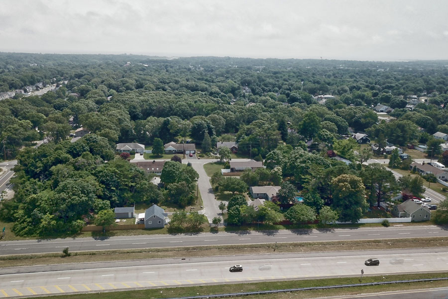
East Patchogue is a hamlet and census-designated place in the Town of Brookhaven, Suffolk County, on Long Island’s South Shore. Located immediately east of Patchogue Village and extending toward Bellport, the community reaches south toward the Great South Bay and includes residential neighborhoods, historic areas, waterfront communities, local businesses, parks, marinas, and portions of the old South Country Road corridor.
East Patchogue had 21,580 residents in the 2020 Census. Although closely connected with neighboring Patchogue, it has a history and identity of its own. Swan River Neck and Pine Neck were settled long before the modern suburban community developed, while the historic Hagerman area became the setting for an unusual experimental railroad during the 1890s. Surviving places such as the 1858 Swan River Schoolhouse and Avery Homestead County Park provide visible connections to the community’s agricultural, maritime, and educational past.
History of East Patchogue
The history of East Patchogue is closely connected with the necks of land extending toward the Great South Bay. During the 18th century, Swan River Neck and Pine Neck became identifiable areas within what is now East Patchogue. Following a land lottery in 1758, settlement increased across this part of the South Shore, with families including the Averys, Smiths, Robinsons, and Roes becoming associated with the area.
Farming, maritime trade, and lumbering were important early activities. The surrounding woodlands supplied cordwood at a time when New York City created substantial demand for fuel, and a sawmill operated at Swan Creek where lumber could conveniently be loaded aboard vessels. The creeks and protected waterways leading into the Great South Bay also supported fishing, shellfishing, boating, and other maritime activity that characterized communities throughout the South Shore.
South Country Road became an important part of this development. The route was one of Brookhaven’s early east-west roads along the southern portion of the town and eventually formed part of the principal overland connection between communities along the South Shore. Portions of the historic route through East Patchogue and neighboring communities retained the South Country Road name after newer highway alignments were constructed.
Swan River and the 1858 Schoolhouse
The Swan River area preserves one of East Patchogue’s most tangible links to its 19th-century past. Brookhaven created a separate school district for East Patchogue in 1857, with Norton Robinson serving as its first trustee. Robinson purchased a small parcel from Stephen S. Roe and his wife, Huldah, specifically for construction of a school.
The Swan River Schoolhouse was completed in 1858 on what is now Roe Avenue. The one-room school had separate entrances for boys and girls, a bell tower, and the simple interior arrangements typical of rural Long Island schools of the period. The local school district remained independent until 1936, when it was absorbed into the Patchogue school system.
In 1962, the school district transferred the building to the Town of Brookhaven for use as a museum. The Swan River Schoolhouse at 31 Roe Avenue is now a Brookhaven Town historic site and was added to the New York State and National Registers of Historic Places in 2017. Its surviving desks, benches, stove, bell, and other furnishings help illustrate what education was like in a small South Shore community during the 19th century.
The Avery Homestead
Another important piece of East Patchogue history survives at the Avery Homestead on South Country Road. The property has associations with the Avery family extending back more than 250 years and preserves a portion of a landscape that once looked very different from the suburban neighborhoods surrounding it today.
Humphrey Avery acquired land in the area in the 18th century, and generations of the family remained connected with the property. The surviving homestead includes a house dating to about 1820, a later Queen Anne-style residence, a historic fountain, and a large Dutch Colonial Revival-style barn.
Charles W. Avery established the Swan River Nursery on the property in 1898. The nursery eventually encompassed approximately 200 acres and became known for ornamental plants, evergreens, and other horticultural products. The business operated for much of the 20th century before the surrounding area was transformed by suburban development.
The surviving 11-acre homestead was acquired for preservation and is now Avery Homestead County Park. The Greater Patchogue Historical Society conducts tours during selected events and by arrangement, while restoration efforts are intended to preserve the property’s buildings, grounds, and agricultural history for future generations.
Hagerman and the Experimental Bicycle Railroad
The eastern portion of today’s East Patchogue also contains the historic area known as Hagerman. Although Hagerman is no longer recognized as a separate census-designated community, the name survives locally through organizations and institutions including the Hagerman Fire Department.
The area was named for George E. Hagerman, who was associated with the New York and Brooklyn Suburban Investment Company during the late 19th century. The company acquired and marketed property in the East Patchogue and Bellport area, selling inexpensive lots during a period when developers hoped railroad expansion would encourage substantial growth in central and eastern Suffolk County.
Hagerman also had its own Long Island Rail Road station. The small station opened around 1890 along the Montauk Branch between Patchogue and Bellport and remained in service until 1929. Although the station disappeared, the Hagerman name continued to identify this portion of East Patchogue.
Even more unusual was an experimental transportation system constructed here during the 1890s. The Boynton Bicycle Railroad used a single load-bearing rail at ground level with an overhead rail that stabilized the narrow railcar. A roughly two-mile electrified experimental line ran from the Hagerman area south toward the Great South Bay.
The system was promoted as a potentially faster and less expensive alternative to conventional railroads, and an electric car known as the Rocket was demonstrated on the East Patchogue line. The ambitious plans never developed into the proposed larger railroad network, and the experimental line was eventually dismantled in 1904. A historical marker on North Dunton Avenue commemorates the unusual experiment, giving East Patchogue a small but distinctive place in the history of American transportation.
From Rural Community to South Shore Suburb
East Patchogue remained a landscape of farms, nurseries, woodlands, waterways, and scattered homes well into the period when neighboring Patchogue was developing as an important South Shore commercial center. The arrival of improved roads, automobiles, and postwar housing development gradually transformed the hamlet into the predominantly suburban community seen today.
The relationship between East Patchogue and Patchogue can sometimes cause confusion. Patchogue is an incorporated village with its own municipal government, while East Patchogue is an unincorporated hamlet and census-designated place governed as part of the Town of Brookhaven. The two communities nevertheless share transportation routes, schools, shopping areas, cultural institutions, waterfront resources, and a broader regional identity.
East Patchogue also incorporates several older local identities and waterfront neighborhoods rather than functioning around a single traditional downtown. This gives the hamlet a different character from Patchogue Village, with residential streets, neighborhood commercial corridors, historic properties, and bayfront areas spread across a relatively large geographic area.
Great South Bay and Waterfront Life
The Great South Bay has influenced East Patchogue throughout its history. Creeks and waterways flowing through the community provided transportation and access to fishing, shellfishing, lumber shipping, and other maritime trades long before the shoreline became primarily residential and recreational.
Today, marinas, private waterfront communities, docks, and residential waterways continue that connection with the bay. Boating, fishing, kayaking, and other warm-weather activities are part of the lifestyle in southern East Patchogue, while nearby public waterfront destinations provide additional opportunities to experience the South Shore.
Nearby recreation includes Corey Beach in Blue Point, Shorefront Park in Patchogue, and the barrier-island beaches and natural areas of Fire Island National Seashore. Seasonal ferry service from nearby Patchogue provides another connection with Fire Island, although schedules and destinations vary by season.
Community and Local Life
Modern East Patchogue is primarily residential, with single-family neighborhoods, waterfront homes, apartment and condominium communities, schools, houses of worship, and local shopping and services. Commercial activity is concentrated along major roads, while the western portion of the hamlet benefits from its immediate proximity to downtown Patchogue.
Residents can reach Patchogue’s restaurants, theaters, shops, waterfront attractions, and seasonal events without living within the incorporated village itself. Farther east, East Patchogue transitions toward the communities surrounding Bellport, giving the hamlet a location between two of the better-known village centers on this portion of the South Shore.
Public education reflects this geography as well. Portions of East Patchogue are served by the Patchogue-Medford School District, while eastern portions are served by the South Country Central School District, whose administrative offices are located on Dunton Avenue in East Patchogue.
Transportation
Sunrise Highway provides East Patchogue with its principal high-speed east-west road connection, linking the community with western Long Island as well as destinations farther east. Montauk Highway and South Country Road provide important local connections through the older developed portions of the hamlet and neighboring South Shore communities.
East Patchogue does not have an active Long Island Rail Road passenger station of its own. The nearby Patchogue station on the Montauk Branch provides rail service toward western Long Island and New York City, while Bellport station serves areas farther east. Local bus routes provide additional connections within the broader Patchogue and Brookhaven area.
East Patchogue, New York
Key Facts and Details
| Community | East Patchogue |
| Community Type | Hamlet and census-designated place |
| Town | Town of Brookhaven |
| County | Suffolk County |
| Region | South Shore of Long Island |
| 2020 Census Population | 21,580 |
| 2010 Census Population | 22,469 |
| Land Area | Approximately 8.3 square miles |
| Western Neighbor | Patchogue |
| Nearby Eastern Community | Bellport |
| Waterfront | Great South Bay and associated creeks and waterways |
| Historic Areas | Swan River Neck, Pine Neck, and Hagerman |
| Early Industries | Farming, lumbering, maritime trade, fishing, and shellfishing |
| Historic Road | South Country Road |
| Historic Schoolhouse | Swan River Schoolhouse, built in 1858 |
| Historic Property | Avery Homestead County Park |
| Historic Nursery | Swan River Nursery, established in 1898 |
| Historic Railroad Community | Hagerman, now generally considered part of East Patchogue |
| Former Railroad Station | Hagerman station, approximately 1890 to 1929 |
| Transportation History | Experimental Boynton Bicycle Railroad operated in the East Patchogue area during the 1890s |
| School Districts | Portions are served by Patchogue-Medford and South Country Central school districts |
| Nearest LIRR Service | Nearby Patchogue and Bellport stations on the Montauk Branch |
| Major Roads | Sunrise Highway, Montauk Highway, and South Country Road |
| Nearby Recreation | Great South Bay, Corey Beach, Shorefront Park, marinas, and Fire Island National Seashore |
| Community Character | Residential South Shore community with historic neighborhoods, waterfront areas, local businesses, and close ties to Patchogue |
East Patchogue is more than the residential community immediately east of Patchogue Village. Its history can still be traced through the old Swan River and Pine Neck areas, the 1858 Swan River Schoolhouse, the preserved Avery Homestead, the former Hagerman community, and even the route of an experimental railroad that once promised a new form of transportation across Long Island. Those historical layers now coexist with established neighborhoods, local businesses, marinas, waterways, and convenient access to the Great South Bay, nearby village centers, and major transportation routes, giving East Patchogue a distinct identity within the Town of Brookhaven and the broader South Shore.
Are you ready for fall on Long Island? Check out these local seasonal guides:
🍎 Apple Picking | 🍂 Fall Festivals & Farm Activities | 👻 Haunted Houses | 🎃 Pumpkin Picking
