
Rockaway Inlet
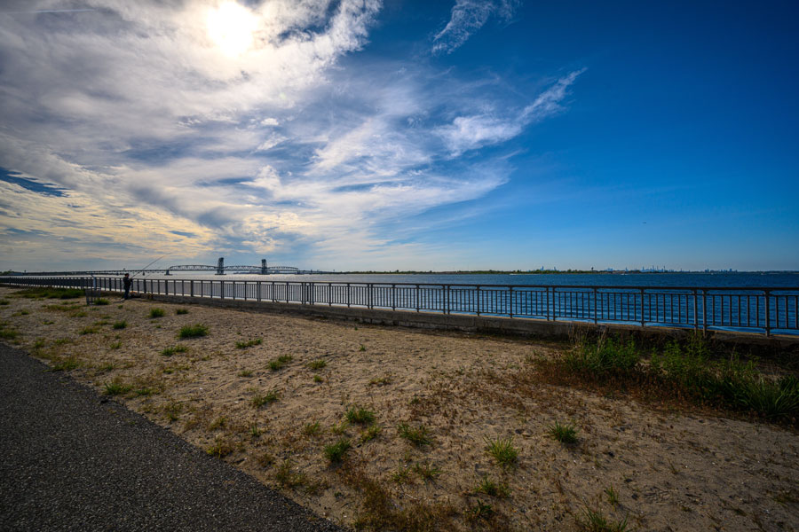
Rockaway Inlet is the tidal entrance connecting Jamaica Bay with the Atlantic Ocean at the western end of the Rockaway Peninsula in New York City, New York. The inlet lies between Rockaway Point and Breezy Point in Queens to the east and the Brooklyn shoreline near Barren Island and Floyd Bennett Field to the west and northwest. It serves as the principal ocean entrance to Jamaica Bay and forms one of the most important tidal passages along the western end of Long Island. The U.S. Army Corps of Engineers maintains a federal navigation channel through the inlet and into Jamaica Bay.
The inlet is part of the larger bays, harbors, inlets and waterways system surrounding Long Island and is geographically distinct from East Rockaway Inlet, which lies farther east between Atlantic Beach and Far Rockaway. Rockaway Inlet opens directly into Jamaica Bay, while East Rockaway Inlet serves the western Hempstead Bay system.
Geography
Rockaway Inlet occupies the western entrance to Jamaica Bay, a large tidal estuary shared by the boroughs of Queens and Brooklyn.
The inlet separates the western end of the Rockaway Peninsula from the Brooklyn side of Jamaica Bay. The peninsula extends eastward through neighborhoods and beaches associated with Rockaway Beach and Far Rockaway, while the Brooklyn shoreline to the northwest includes Barren Island and Floyd Bennett Field.
South and southwest of the inlet are the open waters leading toward the Atlantic Ocean and Lower New York Bay. North of the inlet, the shoreline opens into Jamaica Bay’s extensive system of channels, marsh islands, tidal flats and developed waterfronts.
The U.S. Army Corps of Engineers describes Jamaica Bay as approximately eight miles long and four miles wide, covering about 26 square miles and opening to the Atlantic through Rockaway Inlet.
Jamaica Bay
Jamaica Bay is the principal waterbody served by Rockaway Inlet.
The bay is one of the largest estuarine environments within New York City and contains open water, salt marsh islands, tidal creeks, mudflats and developed shorelines. Much of the bay lies within Gateway National Recreation Area, which protects important coastal habitat in both Queens and Brooklyn.
Ocean water entering through Rockaway Inlet drives tidal circulation throughout Jamaica Bay. Because the inlet is the bay’s primary connection with the Atlantic, changes in its depth and shape directly influence tidal exchange, salinity and water circulation within the estuary.
The Army Corps maintains both the entrance channel and several interior Jamaica Bay channels used by commercial and recreational vessels.
The Rockaway Peninsula
The Rockaway Peninsula forms the eastern side of the inlet and extends for miles along the southern edge of Queens.
At its western tip is Breezy Point, where sandy beaches and dunes face the inlet, Lower New York Bay and the Atlantic. Farther east are Rockaway Beach and the other neighborhoods extending toward Far Rockaway.
The peninsula separates much of Jamaica Bay from the Atlantic Ocean, making Rockaway Inlet the major opening through which ocean tides reach the bay.
The western Rockaway shoreline is also part of Gateway National Recreation Area, whose Jamaica Bay Unit includes Breezy Point, Fort Tilden, Jacob Riis Park, Jamaica Bay Wildlife Refuge and other protected coastal properties.
Breezy Point
Breezy Point occupies the westernmost end of the Rockaway Peninsula and forms the eastern side of Rockaway Inlet.
The area projects into the waters where Jamaica Bay, Lower New York Bay and the Atlantic Ocean meet. Its beaches, dunes and open shoreline create a distinctly different landscape from the more densely developed portions of Queens farther east.
Breezy Point is included within Gateway National Recreation Area, which extends from this part of New York City southward to Sandy Hook in New Jersey.
The point is also an important navigational landmark because vessels entering Jamaica Bay pass directly offshore before turning into the federal navigation channel.
Brooklyn and Barren Island
The western and northwestern side of Rockaway Inlet lies along Brooklyn.
Barren Island, once a separate island within Jamaica Bay, has been substantially altered by filling and development and is now connected with the Brooklyn mainland. The surrounding shoreline lies near Floyd Bennett Field and the Marine Parkway Bridge.
NOAA maintains a tide-prediction station identified as Barren Island, Rockaway Inlet, reflecting the location’s importance for monitoring tidal conditions at the entrance to Jamaica Bay.
The inlet’s federal navigation channel passes from the Atlantic toward Barren Island before branching into the interior Jamaica Bay channels.
Federal Navigation Channel
Rockaway Inlet forms the entrance to the Jamaica Bay Federal Navigation Channel, maintained by the U.S. Army Corps of Engineers.
The federal project provides an entrance channel from the Atlantic Ocean into Jamaica Bay. The Army Corps describes the outer portion as no less than approximately 20 feet deep and 1,000 feet wide approaching the sea, narrowing farther inside to at least 18 feet deep and 500 feet wide between Rockaway Point and Barren Island.
An Army Corps public notice also identifies the Rockaway Inlet entrance channel as authorized to approximately 20 feet below mean lower low water and 1,000 feet wide.
From the inlet, interior federal navigation channels continue through Jamaica Bay toward Mill Basin, Fresh Creek Basin, Head of Bay, Inwood Creek and Mott Basin.
Marine Parkway Bridge
The Marine Parkway-Gil Hodges Memorial Bridge crosses the mouth of Jamaica Bay just inside Rockaway Inlet, connecting the Rockaway Peninsula with Brooklyn.
The bridge provides a prominent geographic reference point for vessels entering Jamaica Bay. The Army Corps describes the federal interior navigation channels as beginning in the vicinity of the Marine Parkway Bridge before branching along the northern and southern shores of the bay.
The crossing also links Queens with Brooklyn and provides direct road access between the Rockaways and destinations such as Floyd Bennett Field and the rest of southern Brooklyn.
Floyd Bennett Field
Floyd Bennett Field lies immediately northwest of Rockaway Inlet on the Brooklyn shoreline of Jamaica Bay.
Opened as New York City’s first municipal airport, the property later became a naval air station and today forms part of Gateway National Recreation Area. The National Park Service states that the site contains more than 1,300 acres of grassland along with historic aviation structures and recreational facilities.
Its shoreline faces the waters approaching Rockaway Inlet and the Marine Parkway Bridge, making it one of the major landmarks on the Brooklyn side of the bay entrance.
Gateway National Recreation Area
Much of the landscape surrounding Rockaway Inlet is protected within Gateway National Recreation Area.
The National Park Service manages approximately 27,000 acres extending from Sandy Hook, New Jersey, to Breezy Point and Jamaica Bay in New York City. The park contains beaches, salt marshes, wildlife habitat, historic military installations and recreational areas.
Near Rockaway Inlet, protected areas include Breezy Point, Fort Tilden, Jacob Riis Park and Floyd Bennett Field. Farther inside Jamaica Bay is the Jamaica Bay Wildlife Refuge.
The presence of such a large protected landscape within one of the country’s most densely developed metropolitan regions makes Rockaway Inlet unusual among Long Island’s ocean entrances.
Jamaica Bay Wildlife Refuge
The Jamaica Bay Wildlife Refuge lies farther inside Jamaica Bay and is one of the most important wildlife areas connected environmentally with Rockaway Inlet.
The National Park Service describes the refuge as containing more than 12,600 acres of water, salt marshes, freshwater and brackish ponds, upland fields and woods.
Ocean water entering through Rockaway Inlet contributes to the tides and salinity supporting these habitats.
The combination of shallow water, marsh islands and migratory habitat makes the Jamaica Bay system particularly important for birdwatching and nature observation.
Tides and Currents
Rockaway Inlet experiences strong tidal flow as enormous volumes of water move between Jamaica Bay and the ocean.
NOAA maintains a tide station at Barren Island, Rockaway Inlet, providing predictions used by boaters and other marine users.
The relatively narrow entrance compared with the size of Jamaica Bay means that currents can become significant during both flood and ebb tides.
Marine conditions around the outer entrance can also be affected by Atlantic swell, wind and changing shoals. Boaters should use current navigation charts and tide information when entering or leaving the bay.
Boating and Navigation
Rockaway Inlet provides important boating access to Jamaica Bay from the Atlantic.
Once inside the inlet, vessels can travel through federal and local channels toward Brooklyn, Queens and the communities surrounding Jamaica Bay.
The broad entrance is used by recreational boats, fishing vessels and commercial traffic accessing facilities within the bay. The federally maintained dimensions reflect the continued navigational importance of the route.
The surrounding region also contains numerous marinas and smaller boating facilities throughout Jamaica Bay and the adjacent South Shore.
Fishing
Fishing is popular around Rockaway Inlet and Jamaica Bay.
The movement of tidal water between the Atlantic and bay creates productive marine habitat, while the inlet gives anglers access to both protected estuarine waters and offshore fishing grounds.
Shore-based fishing is also available at several nearby locations. The National Park Service notes that Canarsie Pier in Brooklyn has been used as a fishing location for centuries, while other Gateway properties around Jamaica Bay provide additional shoreline access.
Anglers can also explore where to fish, fishing piers and fishing charters around Long Island.
Beaches and Coastal Recreation
The waters surrounding Rockaway Inlet are bordered by some of New York City’s best-known coastal recreation areas.
Rockaway Beach extends eastward along the Atlantic side of the Rockaway Peninsula. Closer to the inlet are Jacob Riis Park, Fort Tilden and Breezy Point.
Jacob Riis Park has served New York beachgoers for more than a century and became part of Gateway National Recreation Area when the park was established in 1972.
Together, these beaches create an extensive public Atlantic shoreline immediately east of Rockaway Inlet.
Salt Marshes and Wildlife
Rockaway Inlet is the marine gateway to one of the most ecologically significant salt-marsh systems in metropolitan New York.
The Army Corps notes that Jamaica Bay is recognized for coastal habitats important to native wildlife, while major restoration projects have focused on rebuilding eroding salt-marsh islands within the bay.
These marshes provide feeding and nesting habitat for birds and nursery habitat for fish and other marine species.
Because tidal water must pass through Rockaway Inlet to reach much of Jamaica Bay, the inlet plays a fundamental role in maintaining the estuary’s salinity and tidal wetlands.
Kayaking and Paddleboarding
Protected portions of Jamaica Bay can provide opportunities for kayaking and paddleboarding.
The immediate Rockaway Inlet entrance is considerably more demanding because of tidal currents, larger vessels, wind and exposure to open ocean conditions.
Quieter creeks, coves and protected shoreline areas farther inside Jamaica Bay are generally more characteristic of recreational paddling.
Rockaway Inlet and East Rockaway Inlet
Rockaway Inlet and East Rockaway Inlet are separate waterways despite their similar names.
Rockaway Inlet lies at the western end of the Rockaway Peninsula and connects the Atlantic Ocean with Jamaica Bay.
East Rockaway Inlet lies much farther east between Far Rockaway and Atlantic Beach and connects the ocean with the Hempstead Bay and Reynolds Channel system.
The two entrances therefore serve completely different estuaries and should not be confused.
Rockaway Inlet within Long Island’s Waterway System
Rockaway Inlet occupies the extreme western end of Long Island’s network of Atlantic inlets.
It connects the Atlantic Ocean with Jamaica Bay, separates the western Rockaway Peninsula from Brooklyn, and provides a federal navigation route into one of New York City’s largest coastal estuaries.
Farther east, Long Island’s South Shore is punctuated by other major ocean entrances including East Rockaway Inlet, Jones Inlet, Fire Island Inlet, Moriches Inlet and Shinnecock Inlet.
Rockaway Inlet differs from most of these in its distinctly urban setting, where federally protected beaches and tidal marshes exist alongside the dense communities and infrastructure of New York City.
Key Facts & Details
| Feature | Details |
|---|---|
| Waterway | Rockaway Inlet within Long Island’s bays, harbors, inlets and waterways system |
| Location | Western end of Long Island |
| City | New York City |
| Boroughs | Queens and Brooklyn |
| State | New York |
| Waterway Type | Tidal ocean inlet and federal navigation entrance |
| Connected Bay | Jamaica Bay |
| Ocean Connection | Atlantic Ocean |
| Eastern Shore | Breezy Point at the western end of the Rockaway Peninsula |
| Western Shore | Barren Island and the Brooklyn shoreline |
| Nearby Beach Area | Rockaway Beach |
| Nearby Protected Area | Gateway National Recreation Area |
| Nearby Historic Recreation Area | Jacob Riis Park |
| Nearby Brooklyn Landmark | Floyd Bennett Field |
| Major Bridge | Marine Parkway-Gil Hodges Memorial Bridge |
| Outer Federal Channel | Approximately 20 feet deep and 1,000 feet wide approaching the ocean |
| Inner Entrance Channel | At least approximately 18 feet deep and 500 feet wide between Rockaway Point and Barren Island |
| Navigation Authority | U.S. Army Corps of Engineers |
| NOAA Tide Location | Barren Island, Rockaway Inlet |
| Primary Environmental Role | Provides tidal exchange between the Atlantic Ocean and Jamaica Bay |
| Major Habitats | Salt marshes, tidal flats, open bay waters, beaches and estuarine habitat |
| Popular Activities | Boating, fishing, coastal recreation and birdwatching |
| Nearby Paddling | Kayaking and paddleboarding in protected Jamaica Bay waters |
| Boating Resources | Long Island marinas and boat slips and marinas |
| Fishing Resources | Long Island fishing, fishing piers and fishing charters |
| Nearby Similar Inlet | East Rockaway Inlet, serving Hempstead Bay farther east |
| Known For | Jamaica Bay’s principal ocean entrance, federal navigation channel, tidal exchange and Gateway National Recreation Area |
| Related Waterways Guide | Bays, Harbors, Inlets & Waterways of Long Island |
Rockaway Inlet is the principal ocean gateway to Jamaica Bay, linking one of New York City’s largest estuaries with the Atlantic Ocean between Queens and Brooklyn. Its broad federal navigation channel, proximity to the Rockaway Peninsula, and role in sustaining the tides and wetlands of Jamaica Bay make it one of the most important waterways at the western end of Long Island.
Are you ready for fall on Long Island? Check out these local seasonal guides:
🍎 Apple Picking | 🍂 Fall Festivals & Farm Activities | 👻 Haunted Houses | 🎃 Pumpkin Picking
