
Moriches Inlet
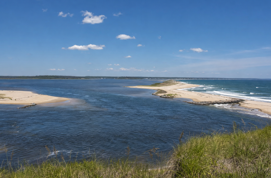
Moriches Inlet is a tidal inlet connecting Moriches Bay with the Atlantic Ocean on Long Island’s South Shore. The inlet separates the eastern end of Fire Island from the western end of Westhampton Island, where Westhampton Dunes is located.
Moriches Inlet is an important coastal opening for boat traffic, fishing, marine rescue and the movement of water between the ocean and Moriches Bay. Its location between the barrier beaches of Suffolk County also makes it one of the most dynamic and environmentally sensitive coastal features on Long Island.
In Short
Moriches Inlet is a navigable opening between the Atlantic Ocean and Moriches Bay. It is used by recreational boaters, commercial and recreational fishermen, the U.S. Coast Guard and other marine users, but strong currents, shifting sandbars, jetties and changing weather conditions can make navigation difficult. Visitors should treat the inlet as an active coastal waterway rather than a conventional swimming or sightseeing beach.
Location and Geography
The inlet lies along the South Shore barrier-island system in Suffolk County. Fire Island is on the western side of the opening, while Westhampton Island and the community of Westhampton Dunes are on the eastern side. The northern side of the inlet opens into Moriches Bay, a large estuarine waterway bordered by communities including East Moriches, Center Moriches and Moriches.
The shape and depth of the inlet are influenced by tides, storms, waves and the continuous movement of sand along the barrier beach. Sandbars and shoals can shift over time, and conditions that appear manageable from shore may be hazardous to swimmers, kayakers and small boats.
Boating and Navigation
Moriches Inlet provides boat access between Moriches Bay and the Atlantic Ocean. The inlet is used by recreational boats, fishing vessels and emergency-service craft, but boaters must account for strong tidal currents, breaking waves, shoaling and changing channel conditions.
Jetties and other coastal structures help maintain the navigation channel, but they do not eliminate the natural hazards associated with an ocean inlet. Boaters should consult current nautical charts, tide information, weather forecasts and local navigation notices before entering or leaving the inlet. Approaching the inlet during rough surf or an outgoing tide can be particularly dangerous.
Fishing and Marine Recreation
The waters around Moriches Inlet are popular with saltwater anglers because the inlet connects the productive waters of Moriches Bay with the open Atlantic. Fishing activity may include striped bass, bluefish, fluke, black sea bass and other seasonal species, depending on current regulations and water conditions.
Fishing from beaches, jetties or boats requires attention to local access rules, New York fishing regulations and the conditions around the inlet. The current, rocks and waves can be dangerous, particularly for anyone standing near the end of a jetty or fishing alone after dark.
Nearby Parks and Access
Public access to the Moriches Inlet area is associated primarily with nearby barrier-beach parks. Cupsogue Beach County Park is located on the eastern side of the inlet in Westhampton, while the western side is connected to the Fire Island barrier-beach system and nearby Smith Point County Park.
Access rules differ by location and may include seasonal fees, parking restrictions, recreational-vehicle permits, beach-driving requirements and closures. Visitors should use designated entrances and verify current conditions with the appropriate park authority before traveling. The inlet itself is not a typical swimming destination, and people should never enter the channel or climb onto restricted coastal structures.
A Changing Coastal Landscape
Moriches Inlet has changed shape several times as a result of major storms and breaches in the barrier island. A significant inlet was created during a powerful coastal storm in 1931, permanently changing the relationship between the ocean, Moriches Bay and the surrounding barrier beaches.
Because barrier islands are naturally mobile, shoreline erosion, sand movement and storm damage remain ongoing concerns. Federal, state and local agencies have worked to maintain navigation and stabilize nearby beaches, but no project can permanently prevent the inlet and surrounding shoreline from changing.
Importance to Search and Rescue
Moriches Inlet is also important to marine emergency operations. The inlet provides access to the Atlantic Ocean for boats based in Moriches Bay and serves as part of the South Shore’s network of coastal routes used by the U.S. Coast Guard and other rescue agencies.
Its position between the ocean and the bay allows rescue vessels to respond to emergencies in both environments. At the same time, the inlet’s currents, surf and shifting bottom make it a challenging area for rescue crews and boat operators.
Moriches Inlet
Key Facts & Details
| Official name | Moriches Inlet |
| Type | Tidal inlet and navigable coastal waterway |
| Connects | Moriches Bay and the Atlantic Ocean |
| Location | South Shore barrier-island system, Suffolk County, New York |
| Western side | Eastern Fire Island |
| Eastern side | Westhampton Island and Westhampton Dunes |
| Nearby communities | East Moriches, Center Moriches, Moriches and Westhampton |
| Primary uses | Boating, fishing, marine transportation and search-and-rescue operations |
| Nearby parks | Cupsogue Beach County Park and Smith Point County Park |
| Water conditions | Strong currents, breaking waves, shifting sandbars and changing channel conditions |
| Swimming | Not recommended in the inlet channel |
| History | A major inlet formed in the area during a 1931 coastal storm |
| Responsible agencies | U.S. Army Corps of Engineers, Suffolk County and other coastal and marine agencies |
| Official information | U.S. Army Corps of Engineers Moriches Inlet fact sheet |
Moriches Inlet is one of the defining openings along Long Island’s South Shore barrier beaches. It links Moriches Bay to the Atlantic Ocean while supporting boating, fishing, coastal recreation and emergency response in a landscape shaped by tides, storms and moving sand. Visitors who want to view or use the area should check current park access, weather, tides, marine conditions and beach regulations before arriving. The inlet is a powerful and changing waterway, and safe access depends on respecting its currents, surf, jetties and protected coastal environment.
Are you ready for fall on Long Island? Check out these local seasonal guides:
🍎 Apple Picking 🍓 Strawberry Picking 🎃 Pumpkin Picking 👻 Haunted Houses 🍂 Farm Festivals
