
Cupsogue Beach County Park
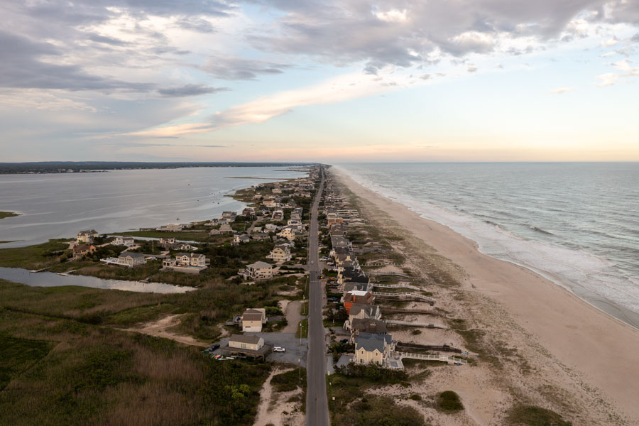
Cupsogue Beach County Park occupies a spectacular stretch of barrier-island shoreline at the western end of Dune Road, beyond Westhampton Beach and Westhampton Dunes, in Suffolk County, New York. With the Atlantic Ocean to the south, Moriches Bay to the north and Moriches Inlet at the western edge of the area, the park offers one of the clearest views of the forces that shape Long Island’s South Shore. Its combination of wide beaches, fishing waters, coastal dunes and expansive scenery makes it a memorable destination for day visitors and permitted overnight campers.
Managed by Suffolk County Parks, the 296-acre property provides seasonal lifeguard-supervised swimming, saltwater fishing, outer-beach recreational vehicle camping and facilities for a day by the shore. The park is reached by road, but it feels far removed from the mainland: the last miles of Dune Road pass through narrow stretches of barrier island where the ocean and bay are never far apart. It is both a recreation area and a sensitive coastal landscape, so weather, tides, beach conditions and conservation rules are part of planning a visit.
Where Cupsogue Beach County Park Is Located
Cupsogue is at the western terminus of Dune Road, not the eastern end. Suffolk County’s official directions begin in the Village of Westhampton Beach: travel south on Jessup Lane, cross the bridge, turn right onto Dune Road and continue west until the road ends at the park. The published address is 975 Dune Road, Westhampton, NY 11978. This route passes through the coastal communities and dune landscapes of the western Hamptons before reaching the public beach area.
The park sits on the western portion of the barrier island commonly associated with Westhampton Dunes. Moriches Inlet separates this shoreline from the eastern end of the Fire Island barrier-island system. The geography is especially interesting because the waterway is not merely a scenic feature: tidal exchange between the ocean and bay affects currents, navigation, shoreline movement and nearby marine habitats. Visitors should distinguish the accessible public park facilities from protected dunes, restricted outer-beach areas and places where strong currents make entering the water unsafe.
History of the Barrier Beach and Moriches Inlet
The story of Cupsogue is inseparable from the shifting sands of Long Island’s South Shore. Wind, waves, tides and storms continually move sand along the barrier beaches, building dunes in some places and eroding shoreline in others. The narrow landforms between the ocean and bay have changed repeatedly, sometimes over the course of a single major storm. Long before modern roads and park facilities, the area was part of a coastal environment used for fishing, navigation and other activities tied to the water.
One of the most consequential changes occurred in March 1931, when a powerful nor’easter opened Moriches Inlet through the barrier island. The opening created a connection between Moriches Bay and the Atlantic Ocean and altered the geography of the western end of the Westhampton barrier beach. The devastating hurricane of September 1938 caused further erosion and flooding throughout the region, but it should not be confused with the 1931 storm that first opened Moriches Inlet. The U.S. Coast Guard’s historical account and federal coastal studies document the inlet’s changing conditions and the effects of subsequent storms.
Over the decades, coastal engineering projects, inlet maintenance and natural sand movement have continued to influence the shoreline. Storms in the late twentieth century produced additional breaches near Cupsogue and Moriches Inlet, demonstrating how vulnerable narrow barrier islands can be. The modern county park allows people to enjoy this landscape while retaining important dune, beach and bay habitats. Its history is a reminder that the coastline visible on a map is not a fixed boundary.
Ocean Swimming and a Day at the Beach
The main attraction is the broad, sandy Atlantic beach. During the designated swimming season, Suffolk County provides lifeguard-supervised swimming in approved areas. Visitors can spend the day sunbathing, enjoying the surf, walking the shoreline or watching the changing light over the water. Beachgoers should swim only where and when lifeguards are on duty, since rip currents, breaking waves and changing conditions can make unguarded water hazardous.
For a more comfortable visit, the park lists restrooms and a food concession among its amenities, although availability can vary with the season and operating schedule. Bringing drinking water, sun protection and clothing for windier conditions is sensible even on a warm day. The open ocean exposure can make the beach feel cooler than inland neighborhoods, particularly during spring and fall. Because this is a barrier-beach park, visitors should also expect occasional access changes following severe weather or coastal maintenance.
Outer-Beach Camping and Recreational Vehicles
Cupsogue is unusual among county beaches because it permits designated outer-beach camping. However, the county’s published campground inventory identifies 35 outer-beach sites rather than ordinary basic tent sites or a traditional campground with electric hookups. Suffolk County specifically states that campers and recreational vehicles are permitted along the access road parallel to the outer beach and that a recreational vehicle permit is required for outer-beach access and camping. Visitors should not assume that standard tent camping is available without checking current rules.
For anyone hoping to stay overnight, the Suffolk County campground information is the appropriate starting point for permit requirements, site availability, reservations and seasonal restrictions. The county generally describes a camping season extending from spring into autumn, with individual park schedules subject to change. Beach driving, overnight parking and recreational vehicle use are regulated separately from ordinary daytime admission. Verify the permitted vehicle type, required equipment, current booking procedures and whether storm-related closures are in effect before making plans.
Surf Fishing and Marine Recreation
Saltwater fishing is one of Cupsogue’s best-known activities. The nearby inlet, surf and bay waters are attractive to anglers pursuing seasonal species such as striped bass, bluefish and fluke. Conditions vary greatly by time of year, water temperature, tides and the movement of baitfish. Some anglers favor the surf-facing beach, while others focus on appropriate bay-side locations, always observing posted access limits and protected habitat boundaries.
The inlet itself deserves special caution. Moving water can be exceptionally strong where the bay exchanges water with the ocean, and the rocks and shoreline near an inlet may be slippery or unstable. Suffolk County’s park description permits diving on the bay side only at slack tide, subject to applicable rules; this should not be interpreted as an invitation to swim or dive in the inlet. Anyone fishing, boating, paddling or diving should check conditions, marine regulations and access restrictions before entering the water.
Birdwatching, Dunes and Coastal Wildlife
Cupsogue’s natural setting extends well beyond its bathing beach. Dune grasses help stabilize windblown sand, while beach vegetation and sheltered bay-side environments support wildlife adapted to salt spray, shifting sediment and changing water levels. Depending on the season, birdwatchers may observe shorebirds, gulls, terns, wading birds and raptors in the broader coastal area. Wildlife sightings are never guaranteed, but the combination of ocean, inlet and bay offers varied habitats within a relatively compact landscape.
Ground-nesting shorebirds and their chicks are particularly vulnerable to disturbance during breeding season. Visitors should obey temporary fencing and posted closures, keep clear of nesting areas and avoid walking across vegetated dunes. Staying on designated paths protects both habitat and the natural dune system that helps buffer the beach against waves and storm surge. Photographers can find compelling subjects without leaving approved public areas, from patterns in the sand to seabirds and distant views of Moriches Bay.
Photography and Coastal Scenery
The park is especially rewarding for landscape photography because it presents two very different waterfronts. Facing south, visitors see the open Atlantic Ocean, breaking surf and a long sandy horizon. Facing north, the view shifts toward the quieter waters and marshy margins of Moriches Bay. On clear days, the contrast between the ocean-facing dunes and sheltered bay can be striking, particularly near sunrise or in the softer light of late afternoon.
The approach along Dune Road is part of the experience. Long, narrow sections of the barrier island make the relationship between road, sand, beach grass and water immediately apparent. Photographers should use authorized pull-offs and parking areas rather than stopping along travel lanes, and should avoid entering restricted habitat or crossing fences to obtain a better view. Aerial photography and drone operations, where allowed, are subject to county rules and applicable aviation restrictions.
Getting There, Parking and Planning Your Visit
The park is a drive-to destination at 975 Dune Road. From the mainland, follow the route through Westhampton Beach and continue west along Dune Road to the county park entrance. Because there is no direct public rail stop at the beach, visitors using the Long Island rail network will need to arrange onward transportation. Traffic can be heavier during summer weekends and holidays, and access may be affected by storms, beach operations or special events.
Parking fees, lifeguard hours, beach permits, concession service, outer-beach vehicle access and camping arrangements are not necessarily the same throughout the year. Check the official Cupsogue Beach County Park page before traveling, particularly if you plan to camp, fish at night or arrive outside the main beach season. For broader rules and park alerts, consult Suffolk County Parks. Current weather, surf conditions and posted instructions at the park should always take priority over general travel descriptions.
Exploring the Surrounding Westhampton Area
A trip to Cupsogue can also be paired with time in Westhampton Beach, where shops, restaurants and village streets offer a different experience from the open barrier beach. The nearby community of Westhampton Dunes illustrates how residential development and shoreline protection coexist on a narrow coastal landscape. Farther east, Quogue offers another glimpse of the South Fork’s quieter village character. These places are close enough to combine with a beach day, but visitors should allow for seasonal traffic along the limited routes connecting the barrier island and mainland.
For travelers interested in Long Island’s wider coastal geography, the relationship between Moriches Bay, Moriches Inlet and the Fire Island National Seashore provides valuable context. Cupsogue is not simply another ocean beach; it is a place where the landscape shows how inlets divide barrier islands and how the Atlantic continually reshapes the edge of the region. This makes it appealing to visitors interested in natural history as well as traditional seaside recreation.
Cupsogue Beach County Park
Key Facts & Details
| Category | Details |
|---|---|
| Location | Western end of Dune Road, near Westhampton Dunes, Suffolk County, New York |
| Address | 975 Dune Road, Westhampton, NY 11978 |
| Park Size | 296 acres, according to Suffolk County Parks |
| Managed By | Suffolk County Parks |
| Coastal Setting | Barrier beach between the Atlantic Ocean and Moriches Bay, near Moriches Inlet |
| Swimming | Seasonal, in designated lifeguard-supervised areas |
| Camping | 35 designated outer-beach sites listed by the county; recreational vehicle permit required for outer-beach access and camping. See county campground information. |
| Recreation | Swimming, sunbathing, surf fishing, birdwatching, photography and permitted outer-beach camping |
| Park Amenities | Restrooms, seasonal food concession, fishing areas and regulated outer-beach access |
| Access Route | From Westhampton Beach, cross the bridge at Jessup Lane, turn west onto Dune Road and continue to the end |
| Nearby Places | Westhampton Dunes, Westhampton Beach and Quogue |
| Visitor Information | Official park page for current fees, permits, hours and alerts |
Whether the goal is a summer swim, a permitted overnight stay near the ocean, a day of surf fishing or a quiet look at the changing barrier-island landscape, Cupsogue Beach County Park offers a distinctive perspective on Long Island’s South Shore. Its beaches, dunes, bay views and proximity to Moriches Inlet make the park both a recreational destination and a reminder of the powerful coastal processes that continue to shape the region. Plan around current county rules and weather conditions, respect protected habitats and enjoy one of Suffolk County’s most remarkable public shorelines.
Are you ready for fall on Long Island? Check out these local seasonal guides:
🍎 Apple Picking | 🍂 Fall Festivals | 👻 Haunted Houses | 🦃 Thanksgiving Dinner & Activities