
Hempstead Bay
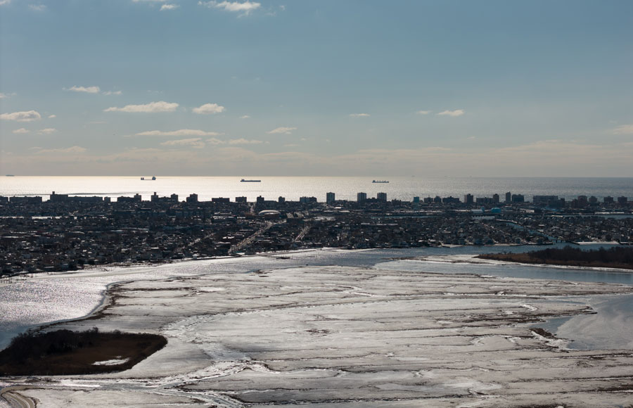
Hempstead Bay is a large tidal bay and estuarine system along the South Shore of Nassau County on Long Island, New York. Its protected waters extend behind the Atlantic barrier islands and are closely associated with waterfront communities including Freeport, Baldwin, Baldwin Harbor, Oceanside, Bay Park, Island Park, Harbor Isle, Barnum Island, Merrick, Bellmore, Long Beach, Lido Beach and Point Lookout.
Rather than being a single uninterrupted body of open water, Hempstead Bay consists of interconnected bays, channels, tidal creeks, mudflats, salt marshes and marsh islands. The system connects with Reynolds Channel and ultimately the Atlantic Ocean through Jones Inlet and East Rockaway Inlet. To the east, the back-bay system transitions toward South Oyster Bay, while Jamaica Bay lies farther west. Together these waterways form part of the extensive lagoon and barrier-island environment that characterizes Long Island’s South Shore.
Geography
Hempstead Bay lies south of the densely developed mainland of southwestern Nassau County and north of the Atlantic barrier beaches. The geography of the bay is shaped by a series of narrow navigation channels, shallow-water basins, tidal marshes and low-lying islands separating the mainland from the ocean.
On the mainland side, communities such as Freeport, Merrick, Bellmore, Baldwin Harbor, Oceanside and Bay Park developed around waterways leading into the bay. Farther west are East Rockaway, Island Park, Harbor Isle and Barnum Island.
Along the ocean side of the system, the barrier-island communities of Atlantic Beach, East Atlantic Beach, Long Beach, Lido Beach and Point Lookout separate much of the bay from the open Atlantic.
The overall Hempstead Bays-South Oyster Bay habitat complex occupies the South Shore between Jamaica Bay and Great South Bay, forming a major back-barrier lagoon and wetland system.
Bays, Channels and Connected Waterways
Hempstead Bay is best understood as part of a larger network of interconnected bays, harbors, inlets and waterways rather than as an isolated bay.
Reynolds Channel is one of the principal navigation channels running through the southern part of the system behind the Long Beach barrier island. Numerous smaller channels branch from it toward marinas, canals and waterfront neighborhoods.
To the east, the Hempstead Bay system approaches South Oyster Bay, another major shallow-water estuary behind the barrier beaches. Farther east, South Shore waters eventually reach the much larger Great South Bay.
The bay also has tidal connections with the Atlantic Ocean through Jones Inlet, between Point Lookout and the Jones Beach barrier island, and East Rockaway Inlet, near Atlantic Beach.
These inlets allow ocean tides to move through the bay twice each day and provide routes between protected South Shore waters and the open Atlantic. A Town of Hempstead aquaculture study identifies Jones Inlet and East Rockaway Inlet as the two tidal inlets affecting conditions within Hempstead Bay.
Reynolds Channel
Reynolds Channel is among the most important waterways within the Hempstead Bay system. It runs generally east-west behind the Long Beach barrier island and provides marine access between several western Nassau communities, marinas and connecting channels.
The waterway passes close to Island Park, Long Beach, Lido Beach and Point Lookout, making it an important recreational boating corridor.
New York State maintains many of the navigation markers along Reynolds Channel and other major state channels, while the Town of Hempstead maintains more than 400 additional markers along local waterways. The U.S. Coast Guard maintains markers in Jones Inlet and East Rockaway Inlet.
Jones Inlet and the Atlantic Ocean
At the southeastern side of the Hempstead Bay system, Jones Inlet provides direct access to the Atlantic Ocean. The inlet lies between Point Lookout and the western portion of Jones Beach State Park.
Jones Inlet is particularly important to recreational fishing and boating because vessels leaving protected waters can reach the ocean without traveling far west toward East Rockaway Inlet.
The surrounding barrier beaches also help protect Hempstead Bay from direct Atlantic wave action, creating the quieter bays, marshes and channels found behind them.
Communities Along Hempstead Bay
The bay has played an important role in shaping many of the communities along the South Shore of Nassau County.
Freeport has one of the strongest maritime identities, particularly around the Nautical Mile, where Woodcleft Canal is lined with restaurants, marinas, charter fishing boats and waterfront businesses.
Immediately west and northwest of Freeport, Baldwin and Baldwin Harbor contain numerous residential canals and waterfront neighborhoods connected to the bay.
Oceanside occupies another large mainland waterfront area, while Bay Park, Island Park, Harbor Isle and Barnum Island sit among the waterways closer to Reynolds Channel and East Rockaway Inlet.
On the barrier island, Long Beach is the largest coastal community in the area. Immediately east are Lido Beach and Point Lookout, while Atlantic Beach and East Atlantic Beach occupy the western portion of the barrier island near East Rockaway Inlet.
Salt Marshes and Tidal Wetlands
One of Hempstead Bay’s most important natural features is its extensive network of salt marshes and tidal wetlands.
Marsh islands occur throughout the bay, particularly between the mainland and barrier beaches. These wetlands provide habitat for fish, shellfish, shorebirds and other wildlife while helping absorb wave energy, store floodwater and trap sediments.
The marshes also make the bay particularly attractive for birdwatching, kayaking and shallow-water exploration.
Much of the broader Hempstead Bays-South Oyster Bay area has been recognized for the significance of its coastal habitats, which include barrier beaches, back-barrier lagoons, tidal marshes, mudflats and shallow estuarine waters.
Fishing
Fishing is one of the traditional recreational uses of Hempstead Bay and its surrounding channels.
Anglers fish from boats, docks, shorelines and nearby beaches, while charter and party boats operate from waterfront communities such as Freeport. The Nautical Mile remains one of Nassau County’s most visible hubs for recreational fishing boats and marine businesses.
Visitors interested in fishing elsewhere around the region can also see the guide to where to fish on Long Island, where to find fishing piers and where to charter a fishing boat.
Shellfishing and Aquaculture
Hempstead Bay has a long history of shellfishing, particularly for hard clams.
The Town of Hempstead operates a shellfish hatchery in Point Lookout where hard clams and oysters are raised as part of local restoration efforts. Juvenile shellfish are used to replenish shellfish beds, and the Town has also developed oyster restoration projects within Hempstead Bay.
Town conservation staff have been seeding local shellfish beds with juvenile hard clams since the 1980s as part of efforts to sustain the shellfishery and maintain the water-filtering role of shellfish populations.
Shellfish harvesting is regulated, and harvesting areas may be restricted or closed depending on water quality and other conditions. Anyone harvesting shellfish should check current state and Town regulations before doing so.
Boating
Hempstead Bay is one of the principal boating areas in southwestern Long Island.
Its protected channels provide access to dozens of marinas, yacht clubs, residential docks and boat basins throughout Freeport, Oceanside, Island Park, Baldwin Harbor and neighboring waterfront communities.
Boaters can travel through Reynolds Channel, enter the Atlantic through Jones Inlet or East Rockaway Inlet, or continue east through the South Shore bay system.
Because large areas of Hempstead Bay are shallow and contain marsh islands, shoals and tidal flats, marked navigation channels are especially important. The Town of Hempstead maintains hundreds of channel markers throughout its waterways.
For additional planning, see where Long Island’s boat slips and marinas are located.
Kayaking and Paddleboarding
The protected nature of many Hempstead Bay channels also makes portions of the system suitable for kayaking and paddleboarding.
Paddlers can explore sheltered waterways near marsh islands and quieter shoreline areas while seeing a side of Nassau County that is largely hidden from its roads and suburban neighborhoods.
Conditions can change significantly with tides, winds and boat traffic, however, and paddlers should understand local conditions before entering major navigation channels.
Beaches and Parks
Although Hempstead Bay itself is principally a back-bay environment, several major Long Island beaches and waterfront parks are located along or immediately beside the system.
Nickerson Beach Park occupies part of the barrier island at Lido Beach, while Jones Beach State Park begins east of Jones Inlet.
The City of Long Beach provides Atlantic beachfront recreation along the southern edge of the barrier island, while Point Lookout occupies the eastern end near Jones Inlet.
These Atlantic-facing beaches contrast sharply with the protected marshes and channels immediately to their north.
Wildlife and Birdwatching
Hempstead Bay’s combination of tidal flats, marsh islands, shallow water and protected shoreline provides habitat for a wide variety of coastal wildlife.
Shorebirds and wading birds feed in shallow areas and along exposed flats, while fish and shellfish use marsh edges and tidal creeks as productive habitat.
The extensive marsh environment makes the bay an important part of Long Island’s coastal ecosystem and a worthwhile destination for people interested in birdwatching and nature observation.
Environmental Importance
Hempstead Bay sits next to some of the most densely developed communities in Nassau County, making environmental protection particularly important.
Stormwater runoff, wastewater, shoreline development, marsh loss and other pressures have affected South Shore bays over time. At the same time, shellfish restoration, marsh conservation, wastewater improvements and local water-quality programs have focused greater attention on protecting the estuary.
The continued restoration of hard clams and oysters is particularly significant because shellfish filter water as they feed, linking the health of the shellfish population directly with the ecological health of the bay.
Hempstead Bay and the South Shore Estuary
Hempstead Bay forms the western portion of a much larger chain of sheltered estuaries extending across the South Shore of Long Island.
To the west lies Jamaica Bay and the Rockaway Peninsula. To the east, Hempstead Bay transitions toward South Oyster Bay and ultimately Great South Bay.
Together with the barrier beaches along the Atlantic Ocean, these waterways form one of the defining geographic features of southern Long Island.
Hempstead Bay – South Shore
Key Facts & Details
Hempstead Bay is one of the most important waterways along the South Shore of Long Island, linking the waterfront communities of Nassau County with a vast network of marshes, channels and protected coastal waters. From the fishing boats and marinas of Freeport and the Nautical Mile to the barrier beaches of Long Beach, Lido Beach, Point Lookout and Jones Beach State Park, the bay is both an important natural estuary and a central part of Long Island’s maritime landscape.
Are you ready for fall on Long Island? Check out these local seasonal guides:
🍎 Apple Picking | 🍂 Fall Festivals & Farm Activities | 👻 Haunted Houses | 🎃 Pumpkin Picking
