
East Rockaway Inlet
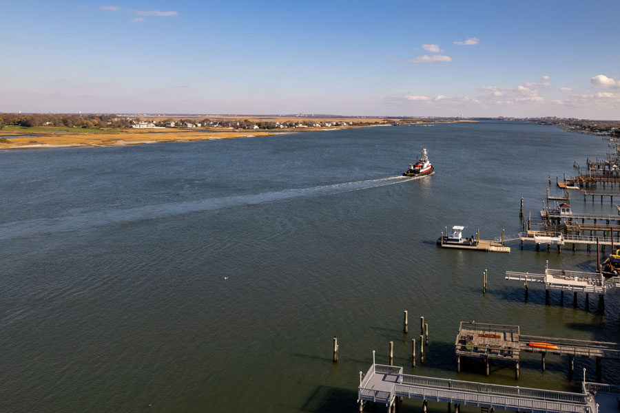
East Rockaway Inlet is a navigable tidal inlet connecting the Atlantic Ocean with the western portion of Hempstead Bay along the South Shore of Long Island in New York. The inlet lies between Far Rockaway and the Rockaway Peninsula in Queens to the west and Atlantic Beach in Nassau County to the east. The U.S. Army Corps of Engineers identifies it as a federal navigation channel approximately 27 miles by water southeast of the Battery in New York City.
The inlet is one of two principal Atlantic openings affecting the Hempstead Bay estuary, along with Jones Inlet farther east. Ocean tides entering through East Rockaway Inlet circulate through a network of bays, marshes and channels that includes Reynolds Channel and the waters surrounding Atlantic Beach, East Atlantic Beach, Long Beach, Island Park, Barnum Island, Harbor Isle and Oceanside. A Town of Hempstead study identifies East Rockaway Inlet and Jones Inlet as the two ocean inlets responsible for much of the tidal exchange within Hempstead Bay.
Geography
East Rockaway Inlet occupies the western end of the Long Beach barrier-island system, where the protected South Shore bays meet the open Atlantic.
The eastern side of the inlet is formed by Atlantic Beach, with East Atlantic Beach and Long Beach continuing eastward along the barrier island. Across the inlet to the west is Far Rockaway, part of the larger Rockaway Peninsula in the New York City borough of Queens.
The Army Corps officially describes the inlet as lying between Far Rockaway in Queens County and Atlantic Beach in Nassau County, at the western end of Long Beach Barrier Island.
Immediately inside the inlet, tidal water enters the complex system of channels, marsh islands and shallow bays associated with Hempstead Bay. This makes East Rockaway Inlet an important geographic transition between the heavily developed New York metropolitan coastline and the extensive tidal wetlands of southwestern Long Island.
Atlantic Beach
Atlantic Beach forms the eastern shoreline of East Rockaway Inlet.
The village occupies the western end of the barrier island that also contains East Atlantic Beach, Long Beach, Lido Beach and Point Lookout.
This position places Atlantic Beach between two very different marine environments. Its southern shoreline faces the Atlantic Ocean, while its northern and western shores face protected channels and the inlet.
NOAA maintains a tide-prediction station specifically identified as East Rockaway Inlet, Atlantic Beach, reflecting the importance of the location for navigation and tidal monitoring.
Far Rockaway and the Rockaway Peninsula
The western side of East Rockaway Inlet is bordered by Far Rockaway, the eastern end of the Rockaway Peninsula.
The peninsula extends westward along the southern edge of Queens and separates portions of Jamaica Bay from the Atlantic Ocean.
Farther west are the neighborhoods and beaches collectively associated with Rockaway Beach. The inlet therefore sits directly at the geographic boundary between Nassau County’s Long Beach barrier island and the New York City shoreline.
Sand dredged from East Rockaway Inlet has repeatedly been placed along Rockaway Beach to restore areas affected by coastal erosion, directly linking maintenance of the inlet with shoreline protection on the Rockaway Peninsula.
Hempstead Bay
Hempstead Bay lies immediately inland from East Rockaway Inlet and forms one of the largest tidal wetland and back-bay systems in southwestern Nassau County.
Unlike a simple open bay, Hempstead Bay contains numerous marsh islands, tidal flats, creeks and navigation channels. Many portions are shallow, while deeper water is concentrated in dredged and naturally maintained channels.
East Rockaway Inlet provides one of the bay system’s two principal connections with the Atlantic. Jones Inlet provides the second ocean entrance farther east near Point Lookout and Jones Beach.
The proximity of the two inlets produces relatively strong tidal exchange, high salinity and substantial currents through portions of Hempstead Bay.
Reynolds Channel
Reynolds Channel is one of the principal waterways connected with East Rockaway Inlet.
The channel extends generally east-west behind the Long Beach barrier island, connecting the inlet area with waters surrounding Island Park, Long Beach, Lido Beach and Point Lookout.
Together, East Rockaway Inlet and Reynolds Channel provide an important marine route between the Atlantic and the protected communities, marinas and waterways of southwestern Nassau County.
The Town of Hempstead notes that New York State maintains most navigation markers along Reynolds Channel, while the U.S. Coast Guard maintains markers within East Rockaway Inlet itself.
Federal Navigation Channel
East Rockaway Inlet is maintained as a federal navigation project by the U.S. Army Corps of Engineers.
The authorized project provides a channel approximately 12 feet deep and 250 feet wide, extending from the 12-foot depth contour in the Atlantic Ocean through the inlet. Army Corps documentation describes the navigation channel as approximately 1.4 miles long.
The project was authorized by the Rivers and Harbors Act of 1930. A rock jetty approximately 4,250 feet long protects the eastern side of the channel. A western jetty of roughly 3,000 feet was originally authorized but was never constructed and was formally deauthorized by Congress in 1977.
The inlet’s federal status reflects its continuing importance for commercial and recreational navigation.
Dredging and Shoaling
East Rockaway Inlet is naturally prone to shoaling as tides, waves and coastal currents move large quantities of sand through the entrance.
The Army Corps periodically dredges the federal channel to restore safe navigation depths. In January 2023, approximately 180,000 cubic yards of sand were removed from the channel and placed along Rockaway Beach. Earlier projects included approximately 346,000 cubic yards dredged in 2019 and about 249,000 cubic yards in 2017.
The Army Corps reported that maintenance work continuing into fiscal year 2026 involved removal of approximately 550,000 cubic yards of shoaled material, with the sand again being beneficially placed along portions of Rockaway Beach.
This practice serves two purposes: maintaining a navigable inlet and returning sand to nearby Atlantic beaches affected by erosion.
The East Jetty
The long rock jetty along the Atlantic Beach side is one of the inlet’s most recognizable features.
The federal project authorizes an eastern jetty approximately 4,250 feet long, helping stabilize the navigation channel and reduce the movement of sand into portions of the entrance.
The jetty was rehabilitated in 2015 as part of ongoing federal maintenance of the inlet.
Like other jetties along Long Island’s South Shore, the structure also influences nearby sediment movement, one reason dredged sand from the inlet is frequently placed on downdrift beaches to the west.
Boating and Navigation
East Rockaway Inlet provides direct boating access between the Atlantic Ocean and the protected waterways behind Long Beach.
Vessels entering from offshore can travel through the inlet into Reynolds Channel and reach marinas, residential docks and boating facilities around Island Park, Oceanside, Barnum Island, Harbor Isle and the broader Hempstead Bay system.
The federal navigation channel also supports commercial activity. The Army Corps reports that the inlet serves maritime commerce associated with an electric generating facility and bulk-product terminals handling materials such as construction aggregate and recycled products.
Because the inlet is affected by tides, ocean swell and rapidly changing shoaling conditions, boaters should consult current charts, navigation aids and channel-condition information.
Tides and Currents
East Rockaway Inlet experiences substantial tidal exchange between the Atlantic and the sheltered bays behind the barrier islands.
NOAA maintains tide predictions for its East Rockaway Inlet station at Atlantic Beach, while the Town of Hempstead provides access to real-time local water information for the inlet.
Tidal flow through East Rockaway Inlet contributes to the relatively high salinity and strong currents found in portions of Hempstead Bay. A Town of Hempstead environmental study specifically identifies the inlet as one of the major factors affecting circulation throughout the estuary.
Conditions can be particularly dynamic near the ocean entrance, where tidal current interacts with Atlantic waves.
Fishing
Fishing is a common activity in the waters surrounding East Rockaway Inlet.
The inlet provides anglers with access to both protected bay habitat and the open Atlantic, while rock structures and rapidly moving tidal water can concentrate marine life near the entrance.
Boaters using the inlet can reach offshore waters directly or remain within the calmer channels and bays behind Atlantic Beach and Long Beach.
The surrounding area also connects with fishing piers, fishing charters and other Long Island fishing locations.
Saltwater anglers age 16 and older are generally required to enroll in New York’s recreational marine fishing registry.
Shellfish and Water Quality
East Rockaway Inlet also influences the environmental conditions of Hempstead Bay.
Ocean water entering through the inlet raises salinity and increases tidal circulation through nearby channels and marshes. These conditions affect shellfish habitat, water quality and marine vegetation throughout the western bay.
Much of western Hempstead Bay is not certified for shellfish harvesting, and classifications can vary considerably by location and season. Current harvesting status should be checked through the New York State Department of Environmental Conservation’s shellfish maps and closure notices.
Kayaking and Paddleboarding
Protected waterways farther inside the bay can provide opportunities for kayaking and paddleboarding.
The immediate inlet itself is a very different environment. Strong tidal flow, boat traffic, ocean swell and shifting shoals can make the navigation channel hazardous for small paddlecraft.
Quieter waters around the marsh islands and protected shoreline of Hempstead Bay are generally more characteristic of recreational paddling in this part of Nassau County.
Beaches and Barrier Islands
East Rockaway Inlet divides two major Atlantic barrier landscapes.
To the east, Atlantic Beach begins the barrier island that continues through East Atlantic Beach, Long Beach, Lido Beach and eventually Point Lookout.
To the west is the Rockaway Peninsula, whose Atlantic shoreline includes Rockaway Beach.
The inlet interrupts this otherwise extensive barrier shoreline and allows Atlantic tides to enter the estuarine waters behind it.
Relationship to Jamaica Bay
Jamaica Bay lies immediately west and northwest of the Rockaway Peninsula and is geographically close to East Rockaway Inlet, although its principal ocean entrance is Rockaway Inlet farther west.
Together, Jamaica Bay, East Rockaway Inlet, Hempstead Bay and the surrounding barrier beaches form part of the complex coastal transition between New York City and Nassau County.
This western end of Long Island contains an unusual combination of densely developed waterfront communities, major urban infrastructure, tidal marshes and federally maintained navigation channels.
East Rockaway and Nearby Mainland Communities
Despite its name, East Rockaway Inlet is not located directly beside the village of East Rockaway.
East Rockaway lies inland to the northeast, along the mainland waterways feeding into the western Hempstead Bay system. The inlet name reflects the broader geographic relationship to the Rockaway area rather than a shoreline location directly within the village.
Nearby mainland communities associated with the inlet’s protected waterways include Oceanside, Bay Park, Island Park, Barnum Island and Harbor Isle. These communities are all part of the densely interconnected waterways surrounding western Hempstead Bay.
East Rockaway Inlet within Long Island’s Waterway System
East Rockaway Inlet is one of the major Atlantic gateways in Long Island’s network of bays, harbors, inlets and waterways.
It connects the Atlantic Ocean with western Hempstead Bay and Reynolds Channel, providing maritime access to waterfront communities throughout southwestern Nassau County.
Its location between Atlantic Beach and the Rockaway Peninsula also makes it a geographic boundary between Nassau County and New York City, while its federally maintained navigation channel remains important to boating, commerce, fishing and coastal management.
East Rockaway Inlet
Key Facts & Details
| Feature | Details |
|---|---|
| Waterway | Atlantic inlet within Long Island’s bays, harbors, inlets and waterways system |
| Location | South Shore of Long Island |
| Counties | Nassau County and Queens |
| State | New York |
| Island | Long Island |
| Eastern Shore | Atlantic Beach |
| Western Shore | Far Rockaway on the Rockaway Peninsula |
| Nearby Barrier Communities | Atlantic Beach, East Atlantic Beach and Long Beach |
| Nearby Mainland Communities | East Rockaway, Oceanside, Bay Park, Island Park, Barnum Island and Harbor Isle |
| Waterway Type | Tidal ocean inlet and federal navigation channel |
| Ocean Connection | Atlantic Ocean |
| Connected Bay System | Hempstead Bay |
| Major Connected Channel | Reynolds Channel |
| Nearby Western Bay | Jamaica Bay |
| Federal Channel Depth | Approximately 12 feet |
| Federal Channel Width | Approximately 250 feet |
| Federal Channel Length | Approximately 1.4 miles |
| Federal Authorization | Rivers and Harbors Act of 1930 |
| Major Structure | Approximately 4,250-foot rock jetty on the Atlantic Beach side |
| Navigation Authority | U.S. Army Corps of Engineers federal channel; U.S. Coast Guard navigation markers |
| Major Environmental Role | Provides Atlantic tidal exchange to western Hempstead Bay |
| Popular Activities | Boating, fishing and coastal sightseeing |
| Nearby Paddling | Kayaking and paddleboarding in protected bay waters |
| Boating Resources | Long Island marinas and boat slips and marinas |
| Fishing Resources | Long Island fishing, fishing piers and fishing charters |
| Known For | Atlantic access, strong tidal exchange, federal navigation channel, rock jetty and connection to Hempstead Bay |
| Related Waterways Guide | Bays, Harbors, Inlets & Waterways of Long Island |
East Rockaway Inlet is one of the principal Atlantic entrances serving western Long Island, connecting the open ocean with Hempstead Bay and Reynolds Channel between Atlantic Beach and the Rockaway Peninsula. Its federally maintained navigation channel, strong tidal exchange and strategic position at the Nassau County-New York City boundary make the inlet an important part of the South Shore’s maritime, recreational and coastal landscape.
Are you ready for fall on Long Island? Check out these local seasonal guides:
🍎 Apple Picking | 🍂 Fall Festivals & Farm Activities | 👻 Haunted Houses | 🎃 Pumpkin Picking
