
Mill River
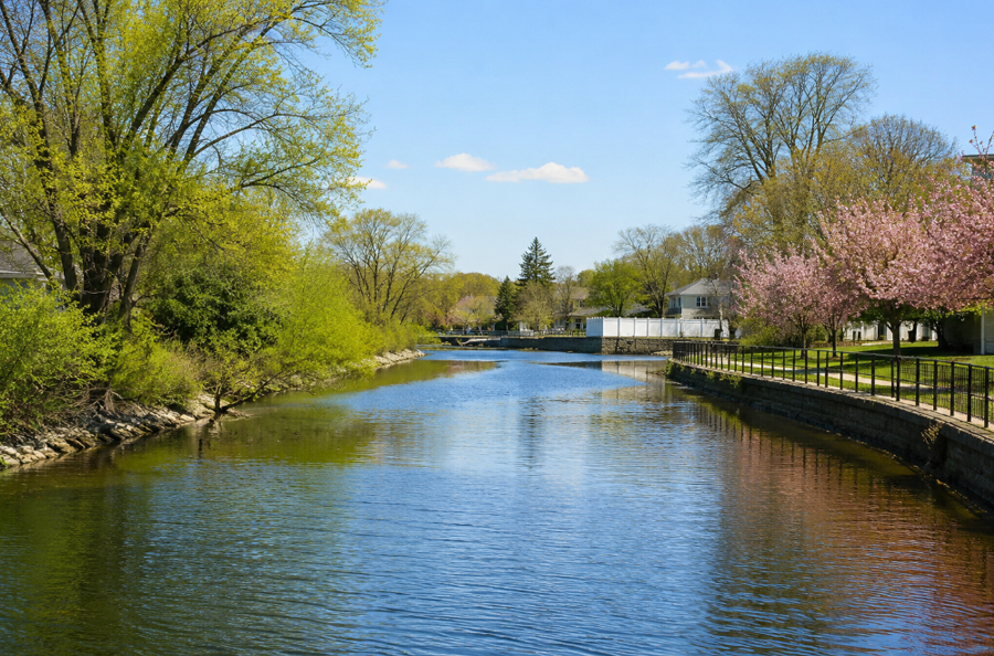
Mill River is a freshwater and tidal waterway flowing through the Town of Hempstead in Nassau County on the South Shore of Long Island, New York. The river and its watershed extend through communities including Hempstead, West Hempstead, Rockville Centre, Lynbrook and East Rockaway before the system reaches Hewlett Bay and the tidal waterways of southwestern Nassau County.
One of the defining features of the Mill River watershed is Hempstead Lake State Park, where a series of freshwater lakes and ponds occupy the northern portion of the drainage corridor. New York State describes the park as lying at the northern end of the Mill River watershed and containing Hempstead Lake, the largest body of freshwater in Nassau County, along with several smaller ponds.
Geography
Mill River flows generally south through western Nassau County toward the tidal waters behind Long Island’s Atlantic barrier beaches.
The watershed begins well north of the river’s lower visible channel and includes a large portion of central and western Nassau County. Water moves southward through the Hempstead Lake system and ultimately toward Rockville Centre, Lynbrook, East Rockaway and Hewlett Bay.
The upper portion of the system is dominated by freshwater lakes, ponds, wetlands and parkland. Farther south, the river becomes increasingly urbanized as it passes through densely developed communities and eventually reaches a narrow tidal estuary before entering Hewlett Bay.
This north-to-south drainage pattern places Mill River within Long Island’s larger system of bays, harbors, inlets and waterways that carry freshwater and stormwater from inland communities toward the South Shore.
Two Mill Rivers on Long Island
Mill River in the Town of Hempstead should not be confused with another waterway of the same name in the Town of Oyster Bay.
Nassau County watershed mapping distinguishes the South Shore Mill River RVC, associated with Rockville Centre, from Mill River (OB) in the Oyster Bay area.
The Mill River described here is the South Shore waterway flowing through the Hempstead Lake and Rockville Centre corridor toward Hewlett Bay.
The separate North Shore Mill River belongs to the Oyster Bay and Oyster Bay Harbor watershed and should be treated as a different geographic feature if covered independently.
Hempstead Lake State Park
Hempstead Lake State Park protects the most substantial open-space area within the upper Mill River watershed.
The park contains Hempstead Lake, several smaller ponds and an extensive network of wooded land, wetlands and recreational areas. New York State identifies Hempstead Lake as the largest freshwater body in Nassau County.
The park is also an important component of regional flood protection because water moving through the upper watershed can be temporarily stored within its lakes, ponds and wetlands before continuing downstream.
New York State has invested heavily in improvements designed to reduce flood risk, improve water quality and enhance public access throughout the Mill River corridor.
Recreational facilities include hiking and biking trails, horseback riding trails, picnic areas, sports courts and an observation deck overlooking Hempstead Lake.
Hempstead Lake
Hempstead Lake is the largest and most prominent freshwater feature within the Mill River system.
The lake was historically created as a reservoir and remains one of the defining geographic features of Hempstead Lake State Park.
Water from Hempstead Lake continues south through additional ponds and channels before eventually becoming part of the downstream Mill River corridor. The watershed’s sequence of connected lakes and ponds means that the river is best understood as a larger hydrologic system rather than simply as one uninterrupted open stream.
The lake and surrounding park also provide habitat for fish, birds and other wildlife while functioning as an important recreational resource within densely developed western Nassau County.
South Pond and Smith Pond
South of Hempstead Lake, the watershed includes several additional freshwater ponds.
South Pond lies downstream from the main lake and helps carry water toward Rockville Centre.
Farther south, Smith Pond is located just north of Sunrise Highway in Rockville Centre. New York State environmental monitoring identifies Smith Pond as a waterbody associated with Morgan Days Park and managed by the Village of Rockville Centre.
These ponds form part of the connected freshwater system through which water moves before reaching the lower Mill River.
The series of lakes and impoundments also reflects the long history of people modifying Long Island streams for reservoirs, mills, flood control and municipal water management.
Rockville Centre
Rockville Centre is one of the communities most closely associated with Mill River.
The river corridor passes through the village after leaving the Hempstead Lake system, and the name remains visible locally in places such as the Mill River Complex, a park and recreation area in Rockville Centre.
Smith Pond and surrounding parkland provide one of the more visible natural sections of the watershed within the village.
The river then continues southward toward the more tidal portions of the system near East Rockaway and Hewlett Bay.
West Hempstead
West Hempstead lies along the upper Mill River corridor immediately north and northwest of Rockville Centre.
The community is closely associated geographically with Hempstead Lake State Park, which provides a major natural buffer within an otherwise heavily developed portion of Nassau County.
The watershed in this area includes freshwater ponds, wooded parkland and drainage channels that ultimately feed the river farther south.
The park’s extensive conservation and resiliency work is therefore important not only to recreational users but also to downstream communities throughout the Mill River watershed.
Lynbrook and East Rockaway
Farther south, Mill River passes through or beside Lynbrook and East Rockaway.
By this point, the surrounding landscape becomes increasingly influenced by tidal waterways and the coastal estuary.
The lower river eventually opens toward Hewlett Bay, placing the Mill River watershed within the same broader South Shore water environment as Hempstead Bay, Reynolds Channel and East Rockaway Inlet.
This transition from inland freshwater ponds to tidal coastal waters is one of the defining characteristics of the river.
Hewlett Bay
Hewlett Bay receives the lower waters of Mill River.
The bay is part of the tidal estuary system along the southwestern edge of Nassau County and ultimately exchanges water with the Atlantic Ocean through the surrounding South Shore channels and inlets.
Federal flood mapping identifies both Mill River and Hewlett Bay as important coastal flood sources within the Town of Hempstead.
The river mouth therefore marks a transition from the freshwater and brackish watershed upstream to a fully tidal coastal environment.
Nearby communities include East Rockaway, Lynbrook, Hewlett and Oceanside.
The Mill River Watershed
The Mill River is surrounded by a much larger drainage area known as the Mill River watershed.
Rainfall and stormwater falling throughout the watershed can eventually move through groundwater, streams, drainage systems, lakes and ponds before entering the river and ultimately Hewlett Bay.
The watershed includes communities well beyond the immediate riverbanks, and studies of the region have focused extensively on flood resilience because downstream areas are vulnerable to both heavy rainfall and coastal storm surge.
The combination of freshwater flooding from the north and tidal flooding from the south became particularly important after Hurricane Sandy, which demonstrated the vulnerability of communities throughout southwestern Nassau County.
Living with the Bay
The Mill River watershed became the focus of one of Nassau County’s most ambitious post-Sandy resiliency programs.
Living with the Bay was developed through the federal Rebuild by Design initiative to create a comprehensive system of environmental and flood-protection projects extending along the Mill River corridor.
The overall concept follows water from the upper watershed through freshwater lakes before it reaches Hewlett Bay through the lower tidal estuary.
At the lower end of the watershed, planning has included coastal restoration strategies intended to reduce the effects of storm surge near Hewlett Bay.
At Hempstead Lake State Park, projects have focused on flood storage, water quality, environmental restoration and recreation.
Hempstead Lake Dam
The Hempstead Lake Dam is one of the most important pieces of flood-control infrastructure within the watershed.
New York State’s recent improvements included work on the approximately 150-year-old dam as part of a broader program intended to reduce downstream flood risk along Mill River.
The dam allows Hempstead Lake to hold a substantial amount of water during major rainfall events, helping regulate how rapidly water moves downstream.
Modern improvements have been designed to make the historic infrastructure more resilient while also improving surrounding ecological conditions.
Flooding and Hurricane Sandy
Communities along Mill River are vulnerable to several different forms of flooding.
Heavy rainfall can send water south through the watershed, while coastal storms can push tidal water northward from Hewlett Bay.
Where these forces meet, communities around Rockville Centre, Lynbrook and East Rockaway can experience significant flood risk.
The scale of the problem became particularly evident during Hurricane Sandy, leading to extensive federal and state planning focused on making the Mill River corridor more resilient.
That work has increasingly treated the entire watershed as one connected system rather than attempting to solve individual flooding problems in isolation.
Freshwater and Tidal Sections
Mill River changes considerably between its upper and lower reaches.
The upper watershed contains freshwater lakes, ponds, streams and wetlands associated with Hempstead Lake State Park.
Moving south, the system becomes increasingly urbanized and confined within developed communities.
Near East Rockaway and Hewlett Bay, the river transitions toward a tidal estuary influenced by coastal tides and storm surge.
This freshwater-to-tidal transition gives Mill River characteristics of both an inland Long Island stream and a South Shore coastal waterway.
Water Quality
Water quality is closely tied to land use throughout the Mill River watershed.
Stormwater flowing from roads, parking lots, residential neighborhoods and commercial areas can carry pollutants toward streams and ponds.
Because the watershed eventually empties into Hewlett Bay, pollutants entering the river system upstream can ultimately affect coastal waters downstream.
New York State’s Mill River improvements have therefore combined flood protection with water-quality projects rather than treating the two issues separately.
Wetlands, ponds and restored natural areas can help slow runoff and remove some pollutants before the water continues downstream.
Wildlife and Habitat
Despite flowing through one of the most developed portions of Long Island, the Mill River corridor contains substantial natural habitat.
Hempstead Lake State Park protects wooded land, ponds, freshwater wetlands and lake shoreline.
These environments provide habitat for waterfowl, songbirds, fish, turtles and other wildlife.
Smaller parks and ponds farther downstream create additional habitat islands within Rockville Centre and surrounding communities.
The river corridor therefore functions as both a drainage system and a fragmented but important ecological connection through western Nassau County.
Fishing
Fishing is possible in several freshwater areas within the Mill River watershed.
Hempstead Lake is among Nassau County’s freshwater fishing locations, with species including carp occurring in the lake.
Fishing opportunities also occur in some of the smaller ponds associated with the state park and downstream freshwater system, subject to current park and state regulations.
Farther downstream, the transition toward tidal waters opens into the broader saltwater fishing environment around Hewlett Bay and the South Shore.
Hiking, Biking and Horseback Riding
The most extensive recreational access within the watershed is found at Hempstead Lake State Park.
The park contains trails for hiking, bicycling and horseback riding, along with picnic areas and other recreational facilities.
These trails allow visitors to experience portions of the upper Mill River watershed on foot rather than viewing the waterway only from surrounding roads and neighborhoods.
The combination of large freshwater lakes and wooded terrain makes the park one of the most significant natural recreation areas in western Nassau County.
Birdwatching
The lakes, ponds and wetlands surrounding the Mill River corridor also provide opportunities for birdwatching.
Waterfowl and other wetland-associated birds use the freshwater portions of the watershed, particularly around Hempstead Lake and the surrounding state park.
The large preserved area provides considerably more continuous habitat than most of the heavily developed communities surrounding it.
Roads and Transportation
Several major transportation corridors cross the Mill River watershed.
Hempstead Turnpike crosses the northern portion of the corridor near Hempstead and West Hempstead, while the Southern State Parkway passes near Hempstead Lake State Park.
Farther south, Sunrise Highway and the Long Island Rail Road cross the watershed near Rockville Centre.
These roads, rail lines and surrounding development have transformed portions of the watershed while also creating substantial impervious surfaces that influence stormwater runoff.
Mill River and the South Shore Estuary
Although the upper Mill River is freshwater, its final destination is the South Shore estuary.
Water traveling south through the watershed eventually reaches Hewlett Bay and the larger network of coastal channels behind Long Island’s barrier beaches.
Nearby tidal systems include Hempstead Bay, Reynolds Channel and East Rockaway Inlet, which provides an important connection between protected western Nassau waterways and the Atlantic Ocean.
Mill River therefore demonstrates the close connection between inland groundwater, freshwater lakes, suburban drainage and Long Island’s coastal bays.
Mill River within Long Island’s Waterway System
Mill River is one of several north-to-south waterways carrying inland water toward the South Shore.
Unlike the longer Carmans River, Connetquot River and Peconic River, Mill River runs almost entirely through densely developed western Nassau County.
Its extensive chain of ponds and lakes, however, preserves a substantial natural corridor through Hempstead Lake State Park before the river moves through Rockville Centre, Lynbrook and East Rockaway toward Hewlett Bay.
The river’s importance has grown beyond geography alone. Its watershed has become a major laboratory for flood resilience, environmental restoration and water management in suburban Long Island.
Mill River, South Shore, Hempstead
Key Facts & Details
| Feature | Details |
|---|---|
| Waterway | Mill River within Long Island’s bays, harbors, inlets and waterways system |
| Location | South Shore of Long Island |
| County | Nassau County |
| State | New York |
| Island | Long Island |
| Town | Town of Hempstead |
| Waterway Type | Freshwater river and pond system transitioning to a tidal South Shore estuary |
| Upper Watershed | Hempstead and West Hempstead |
| Primary River Communities | Rockville Centre, Lynbrook and East Rockaway |
| Nearby Coastal Community | Oceanside |
| Major Protected Area | Hempstead Lake State Park |
| Largest Freshwater Body | Hempstead Lake within Hempstead Lake State Park |
| Other Watershed Ponds | South Pond, Smith Pond and several smaller ponds |
| Lower River Outlet | Hewlett Bay |
| Broader Coastal System | Western Hempstead Bay and neighboring South Shore tidal waters |
| Nearby Navigation Channel | Reynolds Channel |
| Nearby Atlantic Inlet | East Rockaway Inlet |
| Ocean | Atlantic Ocean |
| Major Flood-Control Feature | Hempstead Lake Dam within Hempstead Lake State Park |
| Major Resiliency Program | Living with the Bay / Rebuild by Design |
| Major Environmental Concerns | Flooding, storm surge, stormwater runoff and water quality |
| Major Habitats | Freshwater lakes, ponds, wetlands, wooded parkland, river channel and tidal estuary |
| Popular Activities | Fishing, hiking, bicycling, horseback riding and birdwatching |
| Fishing Resource | Long Island fishing |
| Comparable Long Island Rivers | Carmans River, Connetquot River and Peconic River |
| Not the Same As | North Shore Mill River in the Oyster Bay area |
| Known For | Hempstead Lake State Park, interconnected freshwater ponds, flood resiliency projects and its outlet to Hewlett Bay |
| Related Waterways Guide | Bays, Harbors, Inlets & Waterways of Long Island |
Mill River forms an important freshwater-to-coastal corridor through western Nassau County, carrying water from the lakes and wetlands around Hempstead Lake State Park south through Rockville Centre, Lynbrook and East Rockaway before reaching Hewlett Bay. Its combination of freshwater habitat, suburban development, tidal influence and extensive post-Hurricane Sandy resiliency work makes the river one of the most important watershed systems in southwestern Long Island.
Are you ready for fall on Long Island? Check out these local seasonal guides:
🍎 Apple Picking 🍓 Strawberry Picking 🎃 Pumpkin Picking 👻 Haunted Houses 🍂 Farm Festivals
