
Hurricane Sandy (2012)
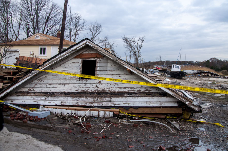
Hurricane Sandy, widely remembered as Superstorm Sandy, was one of the most destructive natural disasters to affect Long Island and the greater New York metropolitan region. The enormous storm struck the northeastern United States on October 29, 2012, bringing historic coastal flooding, destructive winds, extensive power outages, and widespread property damage.
Although Sandy made landfall in southern New Jersey, its enormous wind field pushed water into Long Island’s bays, harbors, and coastal communities. The resulting flooding devastated portions of the South Shore, damaged barrier beaches, disrupted transportation, and left much of the region without electricity. The storm’s consequences extended far beyond the initial emergency, influencing rebuilding decisions, utility operations, coastal protection projects, and emergency planning throughout Nassau and Suffolk Counties.
How Hurricane Sandy Developed
Sandy formed in the Caribbean on October 22, 2012, and strengthened into a major hurricane before moving northward along the Atlantic coast. As the storm approached the northeastern United States, it interacted with another weather system and expanded into an unusually large cyclone with an extensive wind field.
By October 29, Sandy had transitioned into a post-tropical cyclone. It made landfall near the southern New Jersey coast that evening, but its effects extended hundreds of miles beyond the center of the storm. Long Island experienced powerful winds, exceptionally high coastal water levels, heavy rainfall, and extensive flooding.
Wind gusts exceeded 80 mph in some locations, while coastal flooding became particularly destructive as storm-driven water entered the bays and low-lying communities along the South Shore. The combination of Sandy’s size, unusual track, and timing produced one of the most damaging coastal emergencies in Long Island’s modern history.
Coastal Flooding and Damage Across Long Island
Coastal flooding was among Sandy’s most destructive effects. Along the South Shore, seawater entered residential neighborhoods, commercial districts, marinas, and waterfront properties, damaging homes, vehicles, roads, and essential infrastructure.
Communities including Long Beach, Island Park, Freeport, Massapequa, Lindenhurst, and Babylon experienced serious flooding. Low-lying neighborhoods near the region’s bays were especially vulnerable as water moved inland through canals, creeks, and other coastal waterways.
Barrier islands suffered extensive damage. Fire Island and areas surrounding Jones Beach State Park experienced severe erosion, dune damage, overwash, and destruction of coastal infrastructure. Sandy also devastated waterfront neighborhoods in the Rockaways in Queens.
In the hardest-hit communities, the destruction extended well beyond flooded basements. Entire ground floors were inundated, electrical systems were ruined, vehicles were submerged, and some homes sustained structural damage. Boardwalks, docks, marinas, and other waterfront facilities also required extensive repairs or replacement.
Widespread Power Outages and Transportation Disruptions
Hurricane Sandy caused one of the most extensive electrical outages in Long Island’s history. More than one million customers in the Long Island Power Authority service area lost electricity as powerful winds brought down trees and power lines while flooding damaged electrical equipment.
Restoring service became an enormous undertaking. Fallen trees blocked roads, damaged equipment required replacement, and flooded neighborhoods complicated access for repair crews. While electricity returned relatively quickly in some locations, other neighborhoods remained without power for considerably longer, with certain outages lasting for weeks.
Transportation throughout the region was also severely disrupted. The Long Island Rail Road suspended service as flooding, debris, electrical failures, and infrastructure damage affected its operations. Roads and parkways experienced closures, while damage to regional bridges and tunnels complicated travel between Long Island and New York City.
These disruptions made the immediate recovery more difficult. Residents faced challenges obtaining gasoline, reaching workplaces, accessing medical services, and securing essential supplies while emergency personnel and utility crews worked to restore normal conditions.
Economic Damage and the Human Toll
The economic consequences of Hurricane Sandy were enormous. Estimated damage in New York State exceeded $40 billion, with Long Island accounting for a substantial portion of the losses.
Thousands of homeowners faced major repairs, extensive rebuilding, or the loss of their properties. Flood damage affected foundations, electrical systems, heating equipment, walls, flooring, and personal belongings. Some houses required elevation or complete reconstruction, while others were eventually demolished.
Businesses throughout the South Shore also suffered significant losses. Restaurants, retail establishments, marinas, and other businesses faced damaged buildings, destroyed inventory, prolonged power outages, and extended closures. For many owners, recovery involved navigating insurance claims, financing repairs, and rebuilding customer relationships while their communities were still recovering.
The storm also carried a devastating human cost. Long Island residents were among those killed or injured in storm-related incidents involving flooding, falling trees, and other emergencies. Many families were displaced, and some residents could not return to their homes for months. The emotional and financial consequences continued long after debris had been cleared and electricity restored.
Emergency Response and the Long Recovery
As Sandy approached, authorities ordered evacuations in vulnerable coastal areas, including barrier islands and low-lying waterfront neighborhoods. Emergency personnel prepared for flooding, transportation disruptions, and the possibility of widespread damage.
Following the storm, local fire departments, police officers, emergency medical personnel, the National Guard, federal agencies, nonprofit organizations, and volunteers participated in rescue and relief operations. FEMA and the American Red Cross were among the organizations providing assistance to affected residents.
Community organizations and neighbors played an important role in the immediate response. Volunteers helped distribute food and supplies, clear debris, provide temporary shelter, and assist residents whose homes had been damaged. In many neighborhoods, recovery began with residents helping one another before longer-term government assistance and reconstruction programs could be implemented.
Rebuilding required years of work. Federal, state, and local funding supported repairs to public infrastructure, restoration of damaged waterfront facilities, reconstruction of boardwalks, coastal protection projects, and assistance for homeowners. The recovery also exposed difficult questions about rebuilding in flood-prone areas and how communities could reduce their vulnerability to future storms.
How Sandy Changed Long Island’s Electrical System
One of Hurricane Sandy’s most significant institutional consequences involved Long Island’s electric utility system. The extensive outages and prolonged restoration effort generated public criticism of the region’s emergency preparedness, communications, and electrical infrastructure.
The storm contributed to changes in the management of the Long Island Power Authority. In 2014, PSEG Long Island assumed responsibility for day-to-day operation of the electric system while LIPA remained the public authority responsible for the system.
The experience also increased attention to storm preparation, vegetation management, electrical equipment protection, emergency communications, and the ability to restore service following severe weather. Improving the resilience of the electrical network became an important component of the region’s broader recovery efforts.
Rebuilding Homes and Protecting Coastal Communities
Hurricane Sandy changed the way many Long Island homeowners and municipalities approached construction in flood-prone locations. Updated flood maps, building requirements, and insurance considerations influenced decisions about repairing, elevating, or replacing damaged homes.
In some waterfront neighborhoods, elevated houses became a more prominent feature of the landscape as owners rebuilt to meet applicable flood-protection requirements. Other residents faced difficult decisions about the expense of rebuilding, maintaining insurance coverage, or remaining in vulnerable coastal locations.
Public infrastructure also received increased attention. Transportation facilities, roads, drainage systems, and other vulnerable assets became the focus of storm-hardening and flood-mitigation projects intended to reduce damage from future coastal emergencies.
Environmental Damage and Coastal Restoration
Sandy significantly altered portions of Long Island’s shoreline. Powerful waves and storm-driven water eroded beaches, damaged protective dunes, and carried sand across barrier islands. The storm’s effects were particularly evident along Fire Island National Seashore and other exposed Atlantic-facing coastal areas.
In the years that followed, coastal restoration became an important part of the region’s recovery. Beach nourishment, dune reconstruction, wetland restoration, and related shoreline protection projects were undertaken to repair storm damage and improve protection for nearby communities.
These efforts also brought renewed attention to the role of natural coastal features. Beaches, dunes, wetlands, and barrier islands provide important protection against waves and coastal flooding, making their preservation a significant consideration in long-term planning.
Hurricane Sandy’s Lasting Lessons
Hurricane Sandy demonstrated that Long Island’s exposure to coastal storms extends beyond beachfront properties. Communities surrounding bays, canals, creeks, and other low-lying waterways can experience severe flooding even when they are separated from the Atlantic Ocean by barrier islands.
The storm also revealed how closely connected the region’s essential systems are. Electrical failures affected communications and businesses, transportation disruptions complicated emergency operations, and extensive property damage created recovery challenges that continued for years.
Since Sandy, emergency preparedness, evacuation planning, infrastructure protection, and coastal resilience have received greater attention throughout the region. Although no single project can eliminate the risks associated with major coastal storms, the experience continues to inform decisions about development, public infrastructure, and emergency response across Long Island.
Key Facts and Details
| Storm | Hurricane Sandy, commonly called Superstorm Sandy |
| Formation | October 22, 2012, in the Caribbean |
| Landfall | October 29, 2012, in southern New Jersey |
| Storm Classification at Landfall | Post-tropical cyclone |
| Primary Long Island Impact | October 29–30, 2012 |
| Affected Region | Long Island and the greater New York metropolitan area |
| Most Vulnerable Areas | Low-lying coastal communities, particularly along the South Shore and barrier islands |
| Wind Gusts | Exceeded 80 mph in some Long Island locations |
| Coastal Flooding | Severe storm-driven flooding, including record-setting water levels in some coastal areas |
| Majorly Affected Communities | Long Beach, Island Park, Freeport, Massapequa, Lindenhurst, and other coastal communities |
| Barrier Island Damage | Extensive erosion, overwash, and infrastructure damage affecting Fire Island, Jones Beach, and surrounding areas |
| Power Outages | More than one million customers in the LIPA service area lost electricity |
| Transportation Impact | Major disruptions to the Long Island Rail Road, roads, bridges, and tunnels |
| Estimated Economic Damage | More than $40 billion across New York State |
| Emergency Response | Federal, state, and local emergency agencies, nonprofit organizations, and volunteers |
| Utility System Changes | PSEG Long Island assumed day-to-day electrical system operations in 2014 |
| Long-Term Recovery | Housing reconstruction, infrastructure repairs, beach restoration, dune rebuilding, and flood-mitigation projects |
| Continuing Significance | A defining event in Long Island’s coastal planning, emergency preparedness, and infrastructure resilience |
More than a decade after Hurricane Sandy, its effects remain visible across Long Island. Elevated homes, reconstructed boardwalks, restored dunes, and ongoing infrastructure improvements reflect the scale of the storm and the recovery that followed. Sandy remains a defining event in the modern history of Nassau and Suffolk Counties, demonstrating both the vulnerability of coastal communities and the importance of preparing for future storms.
Are you ready for fall on Long Island? Check out these local seasonal guides:
🍎 Apple Picking | 🍂 Fall Festivals & Farm Activities | 👻 Haunted Houses | 🎃 Pumpkin Picking
