
Yaphank, New York
Yaphank is a hamlet and census-designated place in the Town of Brookhaven in central Suffolk County on Long Island. Established along the Carmans River in the early 18th century, the community was originally known as Millville because of the water-powered sawmills and gristmills that operated along the river. Yaphank later became associated with the railroad, Camp Upton, Suffolk County government, agriculture and the development of nearby Brookhaven National Laboratory.
Despite its central location and concentration of major institutions, Yaphank retains an unusually rural and historic character for this part of Long Island. Willow Lake and Lily Lake, the Carmans River, historic homes, wooded neighborhoods, farms, parkland and preserved open space remain important parts of the landscape. The Yaphank census-designated place had 5,974 residents in the 2020 Census spread across approximately 13.64 square miles of land.
History of Yaphank
European settlement around present-day Yaphank began in 1726 along the Carmans River. Before that settlement, the river and surrounding woodlands were used by Indigenous people, including Unkechaug people whose principal communities were located farther south in the Mastic area, near present-day Mastic and Mastic Beach.
The river quickly became central to Yaphank’s development. In 1739, Captain Robert Robinson received permission to dam the Carmans River and construct an upper sawmill. The dam created what became Willow Lake, also known as Upper Yaphank Lake. In 1762, John Homan received permission to build another sawmill farther downstream, and a gristmill and other milling operations followed. The second dam created Lily Lake, or Lower Yaphank Lake.
The mills turned the small farming settlement into a local center of activity. Lumber could be cut, grain could be processed, and farms and homes developed around the river corridor. The road between the mills became Main Street, and the community became known as Millville.
Water-powered milling remained important for more than a century. As newer technology made the mills obsolete, both major mill complexes eventually disappeared, with fires destroying the remaining operations during the early 20th century. The mill ponds survived, however, leaving Willow Lake and Lily Lake as permanent reminders of the industry that created the original village center.
From Millville to Yaphank
The arrival of the railroad helped bring another major change. The Long Island Rail Road was extended through the community in 1844, improving connections between the rural interior of Suffolk County and communities farther west. By 1845, Millville had adopted the name Yaphank.
Local historical accounts trace Yaphank to the Native American word “Yamphanke,” generally interpreted as referring to the bank of a river. The name was especially appropriate for a community whose early settlement, industry, roads, lakes and daily life had developed around the Carmans River.
The railroad continued to influence the community for generations. Today’s Yaphank station on the Long Island Rail Road Main Line preserves that connection, although passenger service is much more limited than at larger stations farther west.
The Yaphank Historic District
Yaphank has preserved an unusually visible collection of buildings from its early history. The Yaphank Historic District encompasses the old Main Street area and contains more than 30 historic houses along with cemeteries, archaeological remains, mill sites, historic markers and other structures associated with the community’s development. Visitors interested in similar preserved properties elsewhere on the Island can explore the Long Island Guide directory of historic houses on Long Island.
The Yaphank Historical Society, founded in 1974, has played an important role in preserving and interpreting this heritage. The organization maintains several historic houses and operates from the Swezey-Avey House overlooking Willow Lake. Historic properties associated with the district include the Homan-Gerard House, Robert and Isabella Hawkins House, Booth House Museum and St. Andrew’s Episcopal Church.
The Homan-Gerard House is particularly connected with Yaphank’s milling history. Members of the Homan family operated the nearby mills beginning in the 18th century, and remains of the old mill complex can still be found along the river. The Carmans River Nature Trail and Sanctuary provides another way to explore the landscape around the historic mill area, while the broader Long Island Guide hiking trails directory identifies additional walking and hiking destinations across Nassau and Suffolk counties.
Mary Louise Booth
One of Yaphank’s most notable residents was Mary Louise Booth, who was born in the community in 1831. Booth became an author, translator, abolitionist, women’s rights advocate and one of the most important women in 19th-century American publishing.
She published a major history of New York City in 1859 and translated dozens of works from European languages. During the Civil War, her translation work helped make European writing about the Union cause available to American readers. In 1867, she became the founding editor of Harper’s Bazar, the publication later known as Harper’s Bazaar, and remained its editor for more than two decades.
Her Yaphank home, built in 1829, survives as the Booth House Museum. The restored building is part of the Yaphank Historic District, was added to the National Register of Historic Places in 2014 and was recognized as a New York Women’s History site in 2015. The Booth House is part of a much larger collection of preserved residences and historic properties found throughout Long Island.
Camp Upton and World War I
Yaphank’s history changed dramatically after the United States entered World War I. In 1917, the federal government established Camp Upton on thousands of acres northeast of the historic hamlet. Named for Civil War general Emory Upton, the enormous military installation became one of the Army’s major training centers for soldiers preparing to serve overseas.
Camp Upton was constructed at extraordinary speed. Railroad cars brought building materials and supplies into the camp, while barracks, hospitals, warehouses, training grounds, theaters and other facilities transformed what had been a largely wooded landscape into a temporary military city.
The camp became closely associated with the Army’s 77th Division, whose soldiers later fought in France. Among the men stationed at Camp Upton was songwriter Irving Berlin. While serving there, Berlin created the military musical Yip Yip Yaphank, which was performed on Broadway in 1918 using soldiers from the camp. The production included “Oh! How I Hate to Get Up in the Morning,” one of Berlin’s best-known songs.
Camp Upton was deactivated after World War I and much of the installation was dismantled. The property later became Upton National Forest, and Civilian Conservation Corps workers participated in reforestation projects there during the Depression. The site would later take on an entirely different role as the home of Brookhaven National Laboratory.
Camp Siegfried and the German American Bund
Another, much darker chapter of Yaphank history unfolded during the 1930s. Camp Siegfried was established in Yaphank as a German-American summer camp and gathering place. It became closely associated with the German American Bund, an antisemitic and pro-Nazi organization that sought to promote support for Adolf Hitler’s regime among German Americans in the United States.
Camp Siegfried was among the most prominent of the Bund’s camps in the United States. Activities included German cultural events and recreation, but the site also became a center for Nazi propaganda and ideological indoctrination. Young people marched in uniforms, swastikas were displayed, Hitler was celebrated, and large crowds traveled by train from New York City to attend gatherings.
The German American Bund reached its greatest visibility during the late 1930s before investigations, criminal cases involving its leadership, growing public opposition and the approach of war weakened the organization. The Bund dissolved after the United States entered World War II. Camp Siegfried remains an important part of Yaphank’s history and of the broader history of American extremism and antisemitism before the war.
Camp Upton Returns During World War II
The former Camp Upton site returned to military service in 1940 as the United States prepared for the possibility of entering World War II. The Army rebuilt the installation, and it once again served as an induction and training center after the United States entered the war.
Later in the war, Camp Upton’s mission shifted toward the treatment and rehabilitation of wounded servicemen returning from overseas. Recreational facilities including swimming pools, bowling alleys and tennis courts were added as part of the rehabilitation program.
Following World War II, the military declared Camp Upton surplus. Rather than dismantling the entire installation again, the federal government selected the property as the site of a new scientific research center. In 1947, Brookhaven National Laboratory was established on the former Army base for research into the peaceful applications of atomic energy.
Brookhaven National Laboratory subsequently developed into one of the nation’s major scientific research institutions, with work spanning physics, chemistry, materials science, biology, medicine, energy, environmental science and other fields. Although the laboratory uses Upton as its postal location, its history remains closely connected with Yaphank through the former military camp and the surrounding Town of Brookhaven.
Suffolk County Farm and Education Center
Agriculture remains visible in Yaphank at the Suffolk County Farm and Education Center on Yaphank Avenue. Suffolk County purchased 170 acres at the site in 1870 for an almshouse and working farm. A large hay barn constructed in 1871 survives and continues to be used for agricultural purposes.
The farm originally helped provide food for the almshouse and later supplied meat and produce to county institutions. By the 1960s, school groups were regularly visiting the property, and its educational role continued to expand. Cornell Cooperative Extension of Suffolk County assumed management of the farm in 1974.
Today, the Suffolk County Farm and Education Center encompasses hundreds of acres and operates as a working educational farm. Programs focus on agriculture, animal science, environmental education, healthy living, STEM and 4-H youth development. Farm animals, demonstration crops, a butterfly house, educational programs, camps and seasonal events make it one of Yaphank’s best-known family destinations. Agriculture remains an important part of the identity of eastern and central Suffolk County, where visitors can also explore Long Island’s broader network of farm stands and farm markets.
The Carmans River, Yaphank Lakes and Recreation
The Carmans River remains one of Yaphank’s defining natural features. The river begins near neighboring Middle Island and flows south through Yaphank and Southaven County Park before continuing toward the protected wetlands surrounding Wertheim National Wildlife Refuge. It eventually reaches Bellport Bay, part of the larger Great South Bay estuary along Long Island’s South Shore.
Willow Lake and Lily Lake originated as mill ponds created by dams during the 18th century, but after the milling industry disappeared they became recreational and scenic features in their own right.
Swezey-Avey Town Park overlooks Willow Lake and provides a small beach, picnic facilities, playground space and access for swimming and kayaking. Restoration work along the river has also included fish-passage improvements intended to reconnect portions of the Carmans River for species including river herring and trout.
Farther south, Southaven County Park protects more than 1,300 acres of pine-oak forest, wetlands and Carmans River habitat. The park provides hiking, camping, freshwater fishing, boating, horseback riding, picnicking, disc golf and other outdoor recreation. Its forested landscape is also part of the broader natural environment associated with the Long Island Pine Barrens.
The river corridor connects today’s recreational landscape with the waterways that supported Yaphank’s original mills and settlement. Farther downstream in Shirley, Wertheim National Wildlife Refuge protects thousands of acres of forest, wetlands, tidal habitat and Carmans River shoreline, creating an important ecological connection between inland Yaphank and the coastal environment surrounding Bellport Bay.
Outdoor Recreation Around Yaphank
Yaphank’s combination of river, lakes, forests and protected open space makes it a useful starting point for exploring outdoor recreation in central Suffolk County. Southaven County Park is included among the established destinations in the Long Island Guide’s hiking trails directory, while additional parks, forests and preserves can be explored through the site’s guides to Long Island parks and nature preserves.
Visitors interested in specific activities can also explore guides to where to hike on Long Island, kayaking, fishing, birdwatching, horseback riding and camping. The extensive protected landscape surrounding Yaphank, Middle Island, Ridge and Manorville makes this portion of Brookhaven particularly important for inland outdoor recreation.
Government and Civic Presence
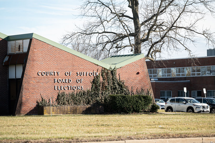
Yaphank has also developed into an important center for Suffolk County government and public services. The hamlet is home to the Suffolk County Board of Elections, Suffolk County Police Department headquarters, correctional facilities, agricultural and educational operations and other county offices.
This concentration of public facilities gives Yaphank regional importance far beyond what its relatively small residential population might suggest. Large institutional properties and preserved open spaces also contribute to the hamlet’s lower population density and more open landscape compared with many communities farther west on Long Island.
Community and Surrounding Area
Modern Yaphank includes established residential neighborhoods, newer housing, wooded areas, historic properties, government facilities, farms and substantial areas of preserved land. Much of the community is served by the Longwood Central School District, one of many public school systems covered by the Long Island Guide’s guide to Long Island school districts.
Yaphank sits among several communities in the central and southern portions of the Town of Brookhaven. Middle Island lies to the north and northwest, Ridge and Manorville lie farther east, and Medford is to the west. To the south are communities including Shirley, Mastic, Brookhaven, Bellport and Patchogue.
Those surrounding communities give Yaphank convenient access to several different parts of central Suffolk. Patchogue provides a major downtown, dining and entertainment district, while Bellport provides access to the Bellport Bay waterfront. To the south and southeast, Shirley connects Yaphank with Wertheim National Wildlife Refuge and the broader South Shore.
Transportation
The Long Island Expressway crosses the Yaphank area and provides the principal east-west highway connection, while Yaphank Avenue and William Floyd Parkway provide important north-south routes. Sunrise Highway is accessible to the south for travel through the South Shore and toward eastern Long Island.
The Yaphank Long Island Rail Road station is located on the Main Line east of Ronkonkoma. Rail service is considerably less frequent than at major western Suffolk stations, so passengers should consult current schedules when planning a trip.
For drivers, Yaphank’s position near the Long Island Expressway also provides relatively direct connections west toward Medford, Farmingville and the more heavily developed portions of central Long Island, while eastbound travel leads toward Manorville, Calverton, Riverhead and the East End.
Yaphank, New York
Key Facts and Details
| Community | Yaphank |
| Community Type | Hamlet and census-designated place |
| Town | Town of Brookhaven |
| County | Suffolk County |
| Region | Central Long Island |
| 2020 Census Population | 5,974 |
| 2010 Census Population | 5,945 |
| Land Area | Approximately 13.64 square miles |
| Early Settlement | Established along the Carmans River beginning in 1726 |
| Former Name | Millville |
| Name Change | The community was known as Yaphank by 1845 |
| Name Origin | Associated with the Native American word “Yamphanke,” generally interpreted as referring to the bank of a river |
| Historic Industry | Sawmills, gristmills, farming and other water-powered milling operations |
| Major Waterway | Carmans River |
| Historic Mill Ponds | Willow Lake and Lily Lake |
| Historic District | Yaphank Historic District, containing more than 30 historic houses and numerous historic sites |
| Historic Properties | Part of Long Island’s broader collection of historic houses and preserved homesteads |
| Notable Historic Resident | Mary Louise Booth, author, translator, abolitionist, women’s rights advocate and founding editor of Harper’s Bazar |
| Military History | Camp Upton operated during World War I and World War II |
| Irving Berlin Connection | Berlin wrote and staged Yip Yip Yaphank while stationed at Camp Upton during World War I |
| 1930s History | Camp Siegfried was associated with the antisemitic and pro-Nazi German American Bund |
| Scientific Connection | The former Camp Upton site became Brookhaven National Laboratory in 1947 |
| Agricultural Attraction | Suffolk County Farm and Education Center |
| Major Recreation Area | Southaven County Park and the Carmans River corridor |
| Natural Region | Woodland and river habitat associated with central Suffolk and the Long Island Pine Barrens |
| Outdoor Recreation | Hiking, camping, fishing, kayaking, horseback riding, picnicking and wildlife observation |
| Downstream Natural Area | Wertheim National Wildlife Refuge |
| Downstream Bay | Bellport Bay and the Great South Bay estuary |
| Civic Role | Major concentration of Suffolk County government, election, police, correctional and public-service facilities |
| Public Safety | Home to Suffolk County Police Department headquarters |
| School District | Much of Yaphank is served by the Longwood Central School District |
| Nearby Communities | Middle Island, Medford, Ridge, Manorville, Shirley, Bellport and Patchogue |
| Rail Transportation | Yaphank Long Island Rail Road station on the Main Line |
| Major Roads | Long Island Expressway, Yaphank Avenue, William Floyd Parkway and nearby Sunrise Highway |
| Community Character | Historic, residential, wooded, institutionally important and comparatively low-density |
Yaphank occupies an unusual place in the history and geography of Suffolk County, combining the remnants of an 18th-century mill community with preserved homes, the Carmans River and its historic lakes, major county institutions, agricultural land, military history and connections to nationally significant figures and events. The same community that grew around sawmills and gristmills later became associated with Mary Louise Booth, Camp Upton and Irving Berlin, the troubling history of Camp Siegfried, and the scientific transformation of the former military property into Brookhaven National Laboratory. Together with the Suffolk County Farm, Southaven County Park, the Yaphank Historic District and substantial surrounding open space, Yaphank also forms an important part of the natural corridor that begins around Middle Island and follows the Carmans River south toward Wertheim National Wildlife Refuge, Bellport Bay and Great South Bay, giving this central Brookhaven hamlet a combination of history, civic importance and protected landscape that is difficult to find elsewhere on Long Island.
Are you ready for fall on Long Island? Check out these local seasonal guides:
🍎 Apple Picking | 🍂 Fall Festivals & Farm Activities | 👻 Haunted Houses | 🎃 Pumpkin Picking
