
Old Inlet
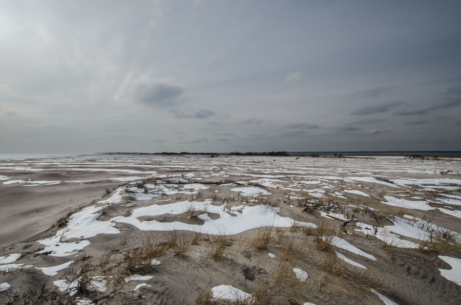
Old Inlet is a historic breach site on Fire Island along the South Shore of Long Island in Suffolk County, New York. Located within Fire Island National Seashore opposite the Bellport area, the site historically connected the Atlantic Ocean with Great South Bay and the waters of Bellport Bay. Today, Old Inlet is no longer an open inlet; the breach created there by Hurricane Sandy in 2012 has filled naturally, and dunes are reforming across the former channel.
The site lies within the Otis Pike Fire Island High Dune Wilderness, the only federally designated wilderness area in New York State, between Smith Point County Park to the east and the more developed portions of Fire Island farther west. Although Old Inlet is now dry land again, its repeated history of opening and closing illustrates the constantly changing nature of Long Island’s barrier islands.
Geography
Old Inlet is located in the eastern portion of Fire Island, a long barrier island separating the Atlantic Ocean from the protected waters of Great South Bay and neighboring South Shore bays.
The site is positioned south of Bellport and the mainland communities of the Town of Brookhaven. On the bay side are the eastern waters of Great South Bay and Bellport Bay, while the Atlantic shoreline lies only a short distance to the south.
This section of Fire Island is particularly narrow and low-lying, making it naturally susceptible to overwash and breaching during major coastal storms. USGS research identifies the Old Inlet location as one that has repeatedly experienced openings through the barrier island.
A Historic Inlet
Old Inlet existed as an open waterway long before Hurricane Sandy.
U.S. Geological Survey research indicates that an inlet formed at approximately this location in 1763 and remained open until 1825. During part of that period it was known as New Inlet, reflecting the fact that it was then an active opening through Fire Island. After the channel eventually closed, the location became known as Old Inlet.
That earlier inlet provided a direct connection between the Atlantic and the eastern Great South Bay system at a time when South Shore barrier-island geography differed considerably from today.
The historical opening is one reason the 2012 Hurricane Sandy breach was not regarded as occurring at an entirely random location. The storm reopened a section of Fire Island that geological and historical records already showed was vulnerable to breaching.
Hurricane Sandy Reopens Old Inlet
On October 29, 2012, Hurricane Sandy struck the South Shore and cut through Fire Island at Old Inlet, once again creating a passage between the Atlantic Ocean and Great South Bay.
Sandy produced three breaches along this portion of the Long Island barrier-island system. Two were mechanically closed soon after the storm, including a breach near Smith Point County Park. The Old Inlet breach was different because it occurred inside the federally designated wilderness area of Fire Island National Seashore. Federal management policy called for the wilderness breach to be monitored initially to determine whether natural processes would close it.
Instead of closing within weeks or months, the opening persisted for approximately a decade and became one of the most closely studied coastal features on Long Island.
The Wilderness Breach
During the years after Sandy, the reopened Old Inlet was generally referred to by researchers and government agencies as the Fire Island Wilderness Breach.
The channel evolved rapidly as ocean waves, tides and moving sand continually reshaped its shoreline and underwater shoals. After significant change during its first several years, researchers observed periods when the breach became relatively stable, although it remained a dynamic coastal feature.
Because the breach connected the Atlantic directly with the eastern portion of Great South Bay, scientists from the National Park Service, U.S. Geological Survey and other institutions monitored its width, depth, tidal flow, shoreline migration and effects on surrounding waters.
Effects on Great South Bay
The opening at Old Inlet created a new source of ocean water entering Great South Bay.
Before the breach, tidal exchange in the eastern part of the bay depended primarily on water entering through established ocean inlets farther away. The new passage allowed Atlantic water to move directly into waters near Bellport Bay and eastern Great South Bay.
Researchers monitored changes in salinity, water temperature, nutrients, turbidity and other water-quality indicators throughout the bay. National Park Service studies reported localized changes associated with the additional ocean exchange, while continuing to emphasize that Great South Bay’s water quality is influenced by numerous natural and human factors.
The breach also became an unusually valuable natural laboratory for studying how barrier-island openings affect estuaries, tidal circulation, marine habitat and coastal landscapes.
Bellport Bay
Old Inlet lies directly south of the eastern Great South Bay waters associated with Bellport Bay, making the communities around Bellport among the mainland areas most closely associated with the breach.
The opening created by Sandy significantly shortened the route between the Atlantic Ocean and this eastern portion of the bay system. Its location consequently became especially important to scientific studies examining changes in water circulation and environmental conditions around Bellport Bay.
The relationship between Old Inlet, Bellport Bay and Great South Bay is one of the clearest examples of how the geography of Fire Island directly affects mainland South Shore waters.
Why the Breach Was Not Immediately Closed
The decision not to immediately fill the Old Inlet breach generated substantial interest following Hurricane Sandy.
Under the federal Breach Contingency Plan, breaches occurring outside the Fire Island wilderness were to be mechanically closed. The Old Inlet opening, however, occurred within the Otis Pike Fire Island High Dune Wilderness, where the plan called for an initial period of monitoring to determine whether the breach would close naturally.
Federal wilderness policy emphasizes allowing natural processes to operate with minimal human interference. The National Park Service therefore continued monitoring the breach while also tracking water levels and potential flooding effects on communities surrounding Great South Bay.
The management plan nevertheless allowed intervention if the breach created unacceptable risks to life, property or surrounding communities.
A Changing Barrier Island
Old Inlet demonstrates why Fire Island is considered a dynamic barrier island rather than a fixed shoreline.
Barrier islands naturally migrate and change through erosion, overwash, deposition and storm-driven breaches. Sand may be removed from one location and deposited elsewhere, creating new beaches, shoals, dunes and marsh habitat.
During the years after Sandy, sediment moving through Old Inlet formed substantial shoals on both its ocean and bay sides. Waves and tidal currents continually altered the shape and position of the opening.
These processes eventually contributed to the natural closure of the channel.
Natural Closure
After remaining open for about a decade, the Old Inlet breach eventually filled naturally.
Current National Park Service information describes Old Inlet as a former breach and notes that the opening has filled while a dune continues to reform across the site.
The closure returned the location to a continuous barrier beach separating the Atlantic from Great South Bay. Instead of flowing through an active inlet, ocean and bay waters are once again divided by beach, dunes and developing vegetation.
The site’s evolution from historic inlet to closed barrier beach, reopened storm breach and closed barrier island again illustrates the natural cycle that has repeatedly shaped Fire Island. USGS research documenting imagery through 2023 confirms that the Sandy-created inlet remained open for roughly ten years before closing.
Otis Pike Fire Island High Dune Wilderness
Old Inlet lies within the Otis Pike Fire Island High Dune Wilderness, part of Fire Island National Seashore.
The wilderness encompasses approximately 1,381 acres and extends for about seven miles from the vicinity of Smith Point County Park westward toward Watch Hill. It includes ocean beach, dunes, interdunal areas, maritime vegetation, salt marshes and shoreline along Great South Bay.
It is the only federally designated wilderness area in New York State, giving the Old Inlet site an unusually undeveloped setting compared with many other portions of Long Island’s coastline.
Visiting Old Inlet
Old Inlet remains accessible as a hiking destination even though the waterway itself has closed.
The National Park Service identifies the site as approximately 1.5 miles from the Fire Island Wilderness Visitor Center, making it roughly a three-mile round trip depending on the route used. The visitor center is located adjacent to Smith Point County Park at the southern end of William Floyd Parkway.
The NPS Burma Trail map lists Old Inlet at approximately 1.6 miles each way from the Wilderness Visitor Center. Conditions within the wilderness can vary because storms, tides and vegetation continually change trails and beach access.
The former breach is now notable primarily for its natural setting, coastal scenery and visible evidence of the barrier island rebuilding itself.
Hiking
Hiking is now one of the principal ways to experience Old Inlet.
Visitors can approach from the Wilderness Visitor Center near Smith Point County Park and travel west through the Fire Island wilderness or along the ocean beach. The National Park Service describes Old Inlet as a popular turnaround point for hikers.
The route passes through an undeveloped coastal landscape of beaches, dunes, thickets and wetlands. Hikers should check weather and tides before traveling because storms and high water can flood portions of the wilderness trail or push ocean water toward the dune line.
Fishing
Fishing is a longstanding recreational activity along the surrounding Fire Island coastline.
Although Old Inlet is no longer an open channel, the nearby Atlantic beaches and Great South Bay shoreline remain part of a broader fishing environment supporting species such as striped bass, bluefish and fluke. The National Park Service permits fishing along many ocean and bay shorelines within Fire Island National Seashore, subject to applicable regulations and local restrictions.
The site’s remote wilderness setting makes it substantially different from developed fishing locations and fishing piers elsewhere on Long Island.
Wildlife and Coastal Habitat
The Old Inlet area contains a mixture of Atlantic beach, dunes, coastal vegetation, wetlands and Great South Bay shoreline.
The Otis Pike Wilderness provides habitat for numerous coastal species, including shorebirds, ospreys, deer and other wildlife. National Park Service materials note that more than 330 bird species live on or migrate through Fire Island.
The undeveloped landscape makes the area especially valuable for birdwatching, wildlife observation and experiencing the natural barrier-island environment away from Fire Island’s populated communities.
Boating and Paddling
During the years when the Sandy breach was open, Old Inlet was not considered a recreational navigation channel.
The National Park Service prohibited boating, swimming, wading and paddling within the active breach because rapidly changing shoals, currents and channel conditions created significant hazards.
Today there is no navigable inlet at the site. Boating takes place in the surrounding Great South Bay waters, while kayaking and paddleboarding are better suited to appropriate protected waterways elsewhere around the bay.
Smith Point County Park
Smith Point County Park is the principal mainland-access gateway for visitors approaching Old Inlet from the east.
The Fire Island Wilderness Visitor Center sits adjacent to the park at the southern end of William Floyd Parkway. From there, Old Inlet is reached on foot through the eastern portion of the national seashore.
Hurricane Sandy also created another breach near Smith Point County Park in 2012. Unlike the wilderness breach at Old Inlet, that opening was mechanically closed soon after the storm under the existing breach-management plan.
The contrasting treatment of the two breaches became an important example of how management policy differs between developed coastal areas and federally protected wilderness.
Fire Island National Seashore
Fire Island National Seashore protects much of Fire Island and substantial portions of the surrounding marine environment.
More than three-quarters of the seashore’s designated acreage consists of marine or estuarine habitat, including portions of the Atlantic Ocean, Great South Bay, Bellport Bay, Narrow Bay and Moriches Bay.
Old Inlet’s location within this protected landscape allowed scientists to observe the Sandy breach largely as a natural coastal process rather than immediately transforming it into a permanently engineered navigation channel.
Old Inlet within Long Island’s Waterway System
Old Inlet occupies a unique place among Long Island’s bays, harbors, inlets and waterways.
Unlike permanent navigable openings such as Moriches Inlet and Shinnecock Inlet, Old Inlet is presently a closed historic inlet site rather than an active waterway.
Its importance comes from its repeated history. An inlet existed there from the 18th into the early 19th century, the barrier island later closed, Hurricane Sandy reopened essentially the same location in 2012, and natural sediment processes eventually closed the breach again about a decade later.
Few places demonstrate the changing geography of Long Island’s South Shore as clearly as Old Inlet.
Old Inlet
Key Facts & Details
| Feature | Details |
|---|---|
| Feature | Old Inlet within Long Island’s bays, harbors, inlets and waterways system |
| Current Status | Closed former inlet; barrier beach and dune are reforming within Fire Island National Seashore |
| Location | Fire Island on the South Shore of Long Island |
| County | Suffolk County, New York |
| State | New York |
| Protected Area | Fire Island National Seashore |
| Wilderness Area | Otis Pike Fire Island High Dune Wilderness within Fire Island |
| Ocean Side | Atlantic Ocean |
| Bay Side | Great South Bay and Bellport Bay |
| Nearby Mainland Community | Bellport |
| Town | Town of Brookhaven |
| Nearby Access Point | Smith Point County Park |
| Historic Inlet Period | Approximately 1763–1825 |
| Historic Name | New Inlet while the earlier channel was open |
| Reopened | October 29, 2012 during Hurricane Sandy |
| 2012–2020s Name | Fire Island Wilderness Breach, Old Inlet breach or New Inlet |
| Sandy Breach Duration | Approximately 10 years before naturally filling |
| Current Landscape | Barrier beach, developing dunes and wilderness shoreline |
| Distance from Wilderness Visitor Center | Approximately 1.5–1.6 miles each way near Smith Point County Park |
| Primary Activity Today | Hiking, coastal sightseeing, fishing and birdwatching |
| Environmental Importance | Historic connection between the Atlantic Ocean and Great South Bay and a major site for studying barrier-island change |
| Nearby Active Inlet to the East | Moriches Inlet |
| Related South Shore Inlet | Shinnecock Inlet |
| Related Storm | Hurricane Sandy |
| Related Waterways Guide | Bays, Harbors, Inlets & Waterways of Long Island |
Old Inlet is no longer an open passage through Fire Island, but its history makes it one of the most revealing coastal features on the South Shore. From an inlet that remained open for decades beginning in the 18th century to the dramatic breach created by Hurricane Sandy in 2012, the site has repeatedly linked the Atlantic Ocean with Great South Bay before natural forces rebuilt the barrier island. Today, the reforming dunes within Fire Island National Seashore provide a visible example of the continuing evolution of Long Island’s coastline.
Are you ready for fall on Long Island? Check out these local seasonal guides:
🍎 Apple Picking 🍓 Strawberry Picking 🎃 Pumpkin Picking 👻 Haunted Houses 🍂 Farm Festivals
