
Shinnecock Inlet
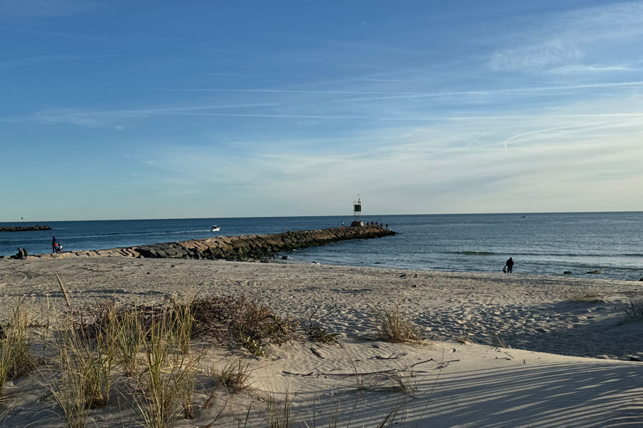
Shinnecock Inlet is a navigable tidal inlet connecting Shinnecock Bay with the Atlantic Ocean along the South Fork of Long Island in Suffolk County, New York. Located at Hampton Bays in the Town of Southampton, the inlet cuts through the Atlantic barrier beach and provides one of the South Fork’s most important passages between protected inland waters and the open ocean.
The modern inlet was created when the Great New England Hurricane of 1938 breached the barrier beach. Unlike many storm-created openings that subsequently closed, Shinnecock Inlet was stabilized and developed as a permanent navigation channel, with stone jetties constructed during the following decades. Today it provides direct ocean access for commercial fishing vessels, charter boats and recreational boaters while also allowing tidal exchange between the Atlantic and Shinnecock Bay.
Geography
Shinnecock Inlet lies along the Atlantic shoreline south of Hampton Bays, between the developed barrier beach to the west and Shinnecock East County Park to the east.
Immediately north of the inlet is Shinnecock Bay, a broad South Shore estuary containing shallow waters, marsh islands, channels and tidal wetlands. Immediately south is the open Atlantic Ocean.
The inlet therefore forms a narrow but important break in the barrier shoreline separating the protected bay from the ocean.
Nearby communities include Hampton Bays, Shinnecock Hills, Southampton and East Quogue, placing the inlet near the western gateway to the Hamptons.
The 1938 Hurricane
Shinnecock Inlet owes its existence to one of the most destructive storms in Long Island history.
Before September 1938, no permanent ocean inlet existed at the present location. Historical U.S. Army Corps of Engineers aerial photographs show that an artificial channel had previously been excavated partway across the barrier beach in an effort to improve water circulation in Shinnecock Bay, but that earlier opening did not remain navigable.
On September 21, 1938, the Great New England Hurricane struck Long Island and opened numerous breaches through the South Shore barrier beaches. Shinnecock Inlet was among the openings created during the storm. Army Corps records state that 12 new inlets were formed between Fire Island Inlet and Montauk Point during the hurricane.
Aerial photographs taken shortly after the hurricane show Shinnecock Inlet occupying approximately the same location where it remains today.
Stabilization of the Inlet
Most storm breaches along barrier islands eventually close naturally as waves and currents move sand along the shoreline. Shinnecock Inlet was instead preserved as a permanent connection between the ocean and bay.
New York State records indicate that the inlet was stabilized with stone jetties between 1947 and 1954, preventing the opening from migrating or filling completely with sand.
The inlet later became a federal navigation project. The current U.S. Army Corps of Engineers project includes two rehabilitated rock jetties, a rock revetment, an ocean entrance channel, an inner navigation channel and a sand deposition basin. The federal project was authorized under the Rivers and Harbors Acts of 1960.
The jetties remain among the inlet’s most recognizable physical features and help guide vessels between Shinnecock Bay and the Atlantic.
Federal Navigation Channel
The U.S. Army Corps of Engineers maintains Shinnecock Inlet as an important federal navigation channel.
The ocean entrance channel is maintained at approximately 10 feet deep and 200 feet wide, extending roughly 0.7 mile from the Atlantic into Shinnecock Bay. An inner channel approximately 6 feet deep and 100 feet wide continues toward the Long Island Intracoastal Waterway.
A large sand deposition basin south of the western jetty helps manage sediment moving through the inlet. Sand removed during maintenance dredging is commonly placed along nearby Atlantic beaches, allowing dredged material to be reused for shoreline stabilization.
Because sand continually moves westward along the South Shore, shoaling remains an ongoing navigation concern and periodic surveys and dredging are necessary to maintain safe channel depths.
Shinnecock Bay
Shinnecock Bay lies immediately north of the inlet and is the principal protected waterbody served by it.
The bay forms part of Long Island’s extensive network of bays, harbors, inlets and waterways behind the Atlantic barrier beaches. Its shoreline is associated with Hampton Bays, Shinnecock Hills, Southampton and neighboring South Fork communities.
The permanent opening of Shinnecock Inlet significantly increased tidal exchange between the bay and the Atlantic. Prior to the 1938 hurricane, Shinnecock Bay had much more limited ocean circulation.
Today, the inlet is the bay’s direct ocean entrance and plays a major role in its tides, salinity, circulation and marine environment.
Shinnecock Harbor and the Working Waterfront
The waters immediately inside Shinnecock Inlet form the center of the Shinnecock Harbor working waterfront.
Commercial fishing vessels, charter boats, docks and marine facilities are concentrated around this portion of Hampton Bays. The harbor benefits from the inlet’s unusually short route between protected dockage and offshore fishing grounds.
The Army Corps describes Shinnecock Inlet as second only to Montauk among New York commercial fishing centers, based on historic fishery statistics, and reports regular use by approximately 30 to 40 commercial and deep-sea charter fishing vessels.
This distinguishes Shinnecock Inlet from many Long Island waterways that primarily serve recreational boating.
A Harbor of Refuge
Shinnecock Inlet also provides access to a protected harbor during poor Atlantic conditions.
The Army Corps identifies Shinnecock Bay as a Critical Harbor of Refuge, meaning vessels traveling along the Atlantic coast can enter through Shinnecock Inlet and reach protected waters rather than remaining offshore.
That function is particularly valuable along the eastern South Shore because navigable ocean inlets are widely spaced.
To the west, the next major ocean entrance is Moriches Inlet, while farther east vessels eventually reach the Montauk area.
Shinnecock Canal and the Peconic Bays
One of the most unusual features of the Shinnecock waterway system is that vessels entering from the Atlantic can continue northward beyond Shinnecock Bay.
Shinnecock Canal connects the northern side of Shinnecock Bay with Great Peconic Bay, creating a navigable passage between the South Shore and the Peconic Estuary.
This means a vessel entering Long Island through Shinnecock Inlet can travel from the Atlantic Ocean through Shinnecock Bay, pass through Shinnecock Canal and continue into the protected waterways separating the North Fork and South Fork.
The inlet and canal therefore form opposite ends of an important north-south marine corridor across the narrow western portion of the South Fork.
Shinnecock East County Park
Shinnecock East County Park occupies the barrier beach immediately east of the inlet.
The park provides expansive views of both the inlet and the Atlantic Ocean and is one of the most direct public locations from which visitors can observe vessels entering and leaving Shinnecock Bay.
Its shoreline includes ocean beach, dunes and the eastern side of the inlet’s rock jetty system. The setting contrasts with the protected bay environment immediately north of the barrier beach.
Fishing, beach recreation and coastal sightseeing are among the area’s principal attractions.
Fishing
Fishing is one of the defining activities associated with Shinnecock Inlet.
Commercial vessels use the inlet to travel between protected docks in Hampton Bays and offshore Atlantic fishing grounds, while recreational anglers fish from boats, nearby beaches and the inlet’s shoreline.
The location is especially attractive because deep ocean water is accessible almost immediately after passing the jetties.
Offshore, New York State maintains Shinnecock Reef, an artificial reef approximately two nautical miles south of the inlet that provides additional marine habitat and recreational fishing opportunities.
The broader area also connects anglers with fishing piers, fishing charters and other fishing locations throughout Long Island.
Boating
Shinnecock Inlet is one of the most important gateways for boating on the eastern South Shore.
Vessels can travel directly between the Atlantic and Shinnecock Bay, reach the numerous marinas around Hampton Bays, or continue through Shinnecock Canal into the Peconic Bays.
The inlet can also present difficult navigation conditions. Ocean swell, tidal currents, shoaling and changing channel depths can combine near the entrance, particularly during poor weather.
NOAA maintains tide and water-level information for Shinnecock Inlet and the Shinnecock Bay entrance, reflecting the importance of tidal conditions to navigation in the area.
Currents and Shoaling
Shinnecock Inlet is a highly dynamic coastal environment.
Ocean waves continually transport sand along Long Island’s Atlantic shoreline, while tidal currents move water through the narrow inlet between Shinnecock Bay and the ocean. These forces contribute to shoaling both within and near the navigation channel.
The federal navigation project includes a sand deposition basin designed to capture some of this material. Maintenance dredging periodically removes accumulated sediment and restores navigable depths.
Recent Army Corps projects have reused dredged sand to stabilize beaches west of the inlet, including work associated with the larger Fire Island to Montauk Point coastal project.
The Barrier Beach
Shinnecock Inlet cuts through the narrow barrier beach separating Shinnecock Bay from the Atlantic.
Barrier beaches are naturally dynamic landscapes shaped by storms, waves, tides and the movement of sand. The dramatic creation of the inlet during the 1938 hurricane demonstrates how quickly these shorelines can change.
West of the inlet, the barrier beach continues along Dune Road toward Hampton Bays and East Quogue. East of the inlet, Shinnecock East County Park occupies the oceanfront barrier.
The inlet’s permanent jetties interrupt the natural movement of sand along this otherwise continuous shoreline, making sediment management an important part of maintaining both the navigation channel and neighboring beaches.
Shinnecock Lighthouse
The Shinnecock area has a long history of navigational aids serving vessels along the Atlantic coast.
The historic Shinnecock Lighthouse once stood near the bay and served mariners traveling this portion of Long Island’s South Shore. The original tower no longer survives, but navigation lights continue to mark the Shinnecock entrance area.
A modern skeletal navigation light stands near Shinnecock Inlet and helps identify this important break in the Atlantic shoreline.
The inlet is part of the larger network of coastal features and lighthouses that historically made navigation around Long Island safer.
Kayaking and Paddleboarding
The immediate inlet is not the same type of paddling environment as the quiet creeks and protected coves elsewhere around Shinnecock Bay.
Strong tidal currents, ocean swell and substantial boat traffic can occur near the jetties and main navigation channel. More sheltered portions of the surrounding bay are generally better suited to kayaking and paddleboarding.
Paddlers using the broader Shinnecock Bay system should remain aware of tides, wind and commercial vessel traffic, particularly when approaching major navigation routes.
Wildlife and Coastal Habitat
The inlet connects two different but closely related marine environments.
On the ocean side, the Atlantic Ocean supports offshore fish, marine mammals and migratory species. On the bay side, Shinnecock Bay contains shallow estuarine waters, salt marshes and tidal flats that provide habitat for fish, shellfish and coastal birds.
The exchange of ocean water through the inlet influences salinity, circulation and water quality throughout the eastern bay.
Nearby marshes and beaches also provide opportunities for birdwatching and wildlife observation.
Shinnecock Inlet within Long Island’s Waterway System
Shinnecock Inlet is one of the most strategically important passages within Long Island’s bays, harbors, inlets and waterways system.
It provides direct access from the Atlantic Ocean into Shinnecock Bay, gives commercial and recreational vessels access to the Hampton Bays waterfront, and connects indirectly through Shinnecock Canal with Great Peconic Bay.
Its creation during the 1938 hurricane permanently changed the geography and hydrology of this portion of the South Fork, while its subsequent stabilization transformed a storm breach into a major navigation route that remains essential to fishing, boating and coastal transportation.
Shinnecock Inlet
Key Facts & Details
| Feature | Details |
|---|---|
| Waterway | Atlantic inlet within Long Island’s bays, harbors, inlets and waterways system |
| Location | South Fork of Long Island |
| County | Suffolk County, New York |
| State | New York |
| Island | Long Island |
| Town | Town of Southampton |
| Primary Community | Hampton Bays |
| Nearby Communities | Shinnecock Hills, Southampton and East Quogue |
| Waterway Type | Tidal ocean inlet connecting a South Shore bay with the Atlantic |
| Northern Waterbody | Shinnecock Bay |
| Southern Waterbody | Atlantic Ocean |
| Northern Route Beyond Bay | Shinnecock Canal to Great Peconic Bay |
| Formed | During the Great New England Hurricane of 1938 |
| Stabilized | Stone jetties constructed during the mid-20th century |
| Federal Navigation Project | Entrance channel, inner channel, two rock jetties, revetment and sand deposition basin |
| Entrance Channel | Approximately 10 feet deep and 200 feet wide |
| Harbor Function | Access to Shinnecock Bay, a federally recognized critical harbor of refuge |
| Commercial Role | Major Long Island fishing entrance serving commercial and charter vessels |
| Nearby Park | Shinnecock East County Park |
| Nearby Lighthouse History | Shinnecock Lighthouse and other Long Island lighthouses |
| Popular Activities | Boating, fishing and coastal sightseeing |
| Nearby Paddling | Kayaking and paddleboarding in more protected portions of Shinnecock Bay |
| Boating Resources | Long Island marinas and boat slips and marinas |
| Fishing Resources | Fishing, fishing piers and fishing charters |
| Known For | Direct Atlantic access, commercial fishing, rock jetties, strong tidal exchange and the 1938 hurricane breach |
| Related Waterways Guide | Bays, Harbors, Inlets & Waterways of Long Island |
Shinnecock Inlet is one of the most important ocean gateways on the South Fork, connecting the Atlantic Ocean with Shinnecock Bay and the maritime community of Hampton Bays. Created by the hurricane of 1938 and later stabilized as a permanent federal navigation channel, the inlet remains essential to commercial fishing, recreational boating, coastal navigation and the movement of tidal water through one of eastern Long Island’s most important estuaries.
Are you ready for fall on Long Island? Check out these local seasonal guides:
🍎 Apple Picking | 🍂 Fall Festivals & Farm Activities | 👻 Haunted Houses | 🎃 Pumpkin Picking
