
Shinnecock Bay, Long Island
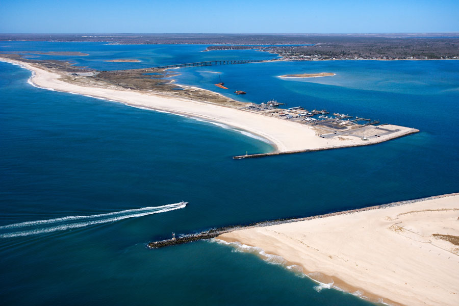
Shinnecock Bay is one of the defining natural features of eastern Long Island’s South Fork – a broad, shallow estuary bordered by Hampton Bays, Shinnecock Hills, and the barrier beach that separates it from the Atlantic Ocean. Long known for its fishing grounds, maritime culture, and deep connection to the Shinnecock Indian Nation, the bay remains both a working waterway and an ecologically important coastal system. Boats still head out before dawn, tidal creeks and shellfish beds continue to shape local life, and the bay’s future depends on the same careful stewardship that has long defined its past.
Location & Geography
Shinnecock Bay covers roughly 9,000 acres and sits at the western end of the Hamptons, within the Town of Southampton. It connects to the Atlantic through Shinnecock Inlet, while its western end meets the Shinnecock Canal and the Peconic Bay system. To the north, roads and neighborhoods follow the shoreline through Hampton Bays, Shinnecock Hills, and the Southampton area; to the south, the narrow barrier beach along Dune Road provides miles of oceanfront and bayfront scenery.
The bay’s shallow depth, marsh edges, and protected coves make it especially important as nursery habitat for marine life. At the same time, its connection to the inlet makes it a major transit route for boaters moving between the bay, the canal, and offshore waters. Conditions on the water can change quickly with tides, wind, and weather, especially near the inlet and bridges.
History & Cultural Significance
The name Shinnecock comes from the Shinnecock people, whose homeland includes the waters and shorelines around the bay. The federally recognized Shinnecock Indian Nation maintains a lasting cultural connection to this landscape, where fishing, shellfishing, travel by water, and stewardship of coastal resources have shaped life for generations.
By the 19th and 20th centuries, commercial fishing, clamming, and other marine trades had made the bay a major economic resource for the South Fork. Much of that working-waterfront heritage is still visible in local marinas, seafood businesses, and fishing culture, even as restoration efforts and changing environmental conditions have become a larger part of the bay’s modern story.
Recreation on the Bay
Shinnecock Bay attracts everyone from casual beachgoers to serious anglers. Popular public access points and nearby recreation areas include:
- Meschutt Beach County Park – a family-friendly bay beach with calmer water, seasonal amenities, and broad sunset views
- Ponquogue Bridge area – a scenic place for walking, sightseeing, and fishing, with wide views over the bay and marshes
- Shinnecock Canal area – known for fishing access, marine traffic, and nearby marinas and launch facilities
- Tiana Beach and other Dune Road access points – gateways to the barrier beach, with both ocean and bay nearby
Boating, kayaking, paddleboarding, and charter fishing are among the most common activities here, and the bay and inlet are widely known for species such as fluke, striped bass, bluefish, and tautog. Public access, launch availability, seasonal fees, and parking rules can vary, so it is smart to check local guidance before heading out. Boaters should also use extra caution near Shinnecock Inlet, where currents and shoaling conditions may change.
Wildlife & Ecology
Shinnecock Bay is one of the most biologically productive estuaries on Long Island. Its shallow waters support eelgrass, tidal wetlands, shellfish habitat, and feeding areas for juvenile fish and migrating birds. Wildlife commonly associated with the bay and its surrounding marshes includes:
- Osprey
- Herons and egrets
- Diamondback terrapins and horseshoe crabs
- Clams, oysters, and other shellfish
- Migratory waterfowl and shorebirds
Because of its ecological importance, the bay is part of the South Shore Estuary Reserve and has been the focus of major research and restoration work by Stony Brook University, The Nature Conservancy, and local partners.
Environmental Concerns & Restoration
Like many coastal systems, Shinnecock Bay faces ongoing pressure from excess nitrogen, algal blooms, habitat loss, shoreline erosion, and storm impacts. In response, researchers and community organizations have supported long-term restoration efforts that may include:
- Shellfish seeding and aquaculture-based restoration
- Eelgrass restoration
- Living shoreline projects
- Water quality monitoring
- Public education and local stewardship programs
These initiatives are intended to improve water clarity, rebuild habitat, strengthen shoreline resilience, and help protect the bay for future generations.
Visitor Notes
For most visitors, the easiest land access to Shinnecock Bay is through Southampton and Hampton Bays via Montauk Highway, Ponquogue Avenue, and Dune Road. Nearby Long Island Rail Road service to Hampton Bays and Southampton can also put travelers within a short drive of the shoreline, marinas, and beaches. Exact beach hours, parking requirements, shellfishing rules, and boat-launch details vary by season and jurisdiction, so check ahead before visiting.
Vicinity of the Shinnecock Inlet
Key Facts
| Feature | Details |
|---|---|
| Location | Town of Southampton, Suffolk County, Long Island |
| Size | About 9,000 acres |
| Type | Shallow tidal estuary and bay |
| Ocean Access | Shinnecock Inlet |
| Connected Waterways | Shinnecock Canal and the Peconic Bay system |
| Bordering Areas | Hampton Bays, Shinnecock Hills, the Southampton area, and the barrier beach along Dune Road |
| Cultural Importance | Waters closely tied to the Shinnecock Indian Nation and South Fork maritime history |
| Main Recreation | Fishing, kayaking, paddling, swimming, and wildlife viewing |
Shinnecock Bay is more than a scenic stretch of water – it is a living cultural, historical, and ecological resource. From its Indigenous heritage to its role in modern marine conservation, the bay reflects both the past and future of Long Island’s South Fork. Whether you arrive by boat, spend time at a bay beach, fish from shore where permitted, or simply watch the light change over the marshes, Shinnecock Bay remains one of the clearest reminders of why Long Island’s coastal environments matter.
Are you ready for fall on Long Island? Check out these local seasonal guides:
🍎 Apple Picking | 🍂 Fall Festivals & Farm Activities | 👻 Haunted Houses | 🎃 Pumpkin Picking
