
Belt Parkway
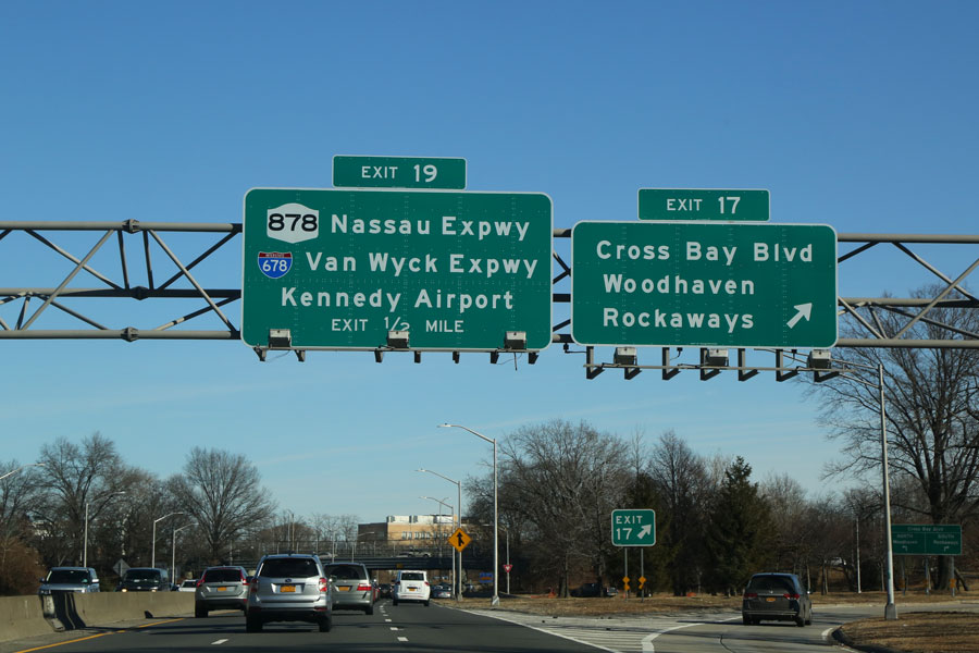
The Belt Parkway is a major part of New York City’s parkway network, tracing the southern edge of Brooklyn and Queens. At roughly 25 miles long, it links Bay Ridge with southeastern Queens and connects drivers to bridges, airport approaches, expressways, and the parkways leading onto Long Island. Originally developed as part of a scenic belt of waterfront parkways, the route today serves mostly as a heavily traveled commuter and regional access road, while still passing parkland and shoreline areas along parts of the way.
History
- Origins: Planned in the 1930s under the direction of Robert Moses, the Belt Parkway was created as part of the larger Belt System around southern Brooklyn and Queens.
- Construction: Built in stages during the 1930s and completed around 1940, the parkway formed part of a broader push to expand automobile access across New York City.
- Opening: By 1940, the full route was in place and had become an important roadway for motorists traveling between Long Island, the outer boroughs, and regional bridges.
- Purpose: Like other parkways in the region, it was designed primarily for passenger vehicles rather than trucks and heavy commercial traffic, with low-clearance overpasses and park-style landscaping helping define its character.
Route and Significance
- Western Terminus: Begins at the Gowanus Expressway (I-278) in Bay Ridge, Brooklyn.
- Eastern Terminus: Reaches the junction with the Southern State Parkway and the Cross Island Parkway near the Queens–Nassau line.
- Length: Approximately 25 miles.
- Restrictions: Parkways in this corridor have vehicle and clearance restrictions. Trucks, trailers, and most commercial traffic are prohibited, and larger vehicles should use posted truck routes instead.
The Belt Parkway forms a major east-west travel corridor for southern Brooklyn and Queens, offering connections to:
- Verrazzano-Narrows Bridge – a direct route to Staten Island and New Jersey via connecting highways.
- Cross Island Parkway – connects to the Throgs Neck and Whitestone Bridges, leading toward the Bronx and New England.
- Southern State Parkway – a principal gateway to Nassau and Suffolk Counties on Long Island.
- JFK Airport – one of the main roadway approaches for travelers using the airport. Access patterns and terminal routing can change, so it is smart to check signs and airport guidance before heading out.
Belt Parkway Junctions
Belt Parkway Exit List (West to East)
| Exit | Destinations / Notes |
|---|---|
| I-278 (Exit 0) | Western terminus – Gowanus Expressway (BQE) west / Brooklyn–Queens Expressway |
| 1 | 65th–67th Streets (Bay Ridge) |
| 2 | 4th Avenue / Fort Hamilton Parkway |
| 3 | Verrazzano-Narrows Bridge west (I-278 toll to Staten Island) |
| 4 | Bay 8th Street / 14th Avenue |
| 5 | Bay Parkway |
| 6S / 6N | Cropsey Avenue South / Stillwell Avenue (Cropsey Avenue North) |
| 7A / 7B | Shell Road (7A, westbound exit/eastbound entrance) / Ocean Parkway (7B, westbound signage) |
| 8 | Coney Island Avenue |
| 9 / 9A / 9B | Knapp Street (Sheepshead Bay): westbound (9), eastbound 9A (southbound), 9B (northbound) |
| 11S / 11N | Flatbush Avenue (south / north) |
| 13 | Rockaway Parkway (Canarsie) |
| 14 | Pennsylvania Avenue |
| 15 | Erskine Street (Gateway Center) |
| 17N / 17S / 17W | Cross Bay Boulevard (17N north / 17S south) / North Conduit Avenue (17W) |
| 18B | Lefferts Boulevard (Aqueduct Racetrack) |
| 19 | Nassau Expressway (NY 878) / I-678 (Van Wyck Expressway) north – JFK Airport access (eastbound only) |
| 20 | JFK Expressway South – JFK Airport (westbound exit / eastbound entrance) |
| 21A / 21B | Rockaway Boulevard (21A) / Farmers Boulevard & Guy R. Brewer Boulevard (21B) |
| 22 | Springfield Boulevard |
| 23A / 23B | North Conduit Avenue / 225th Street (23A, westbound only); Sunrise Highway (NY 27) / Brookville Boulevard (23B, eastbound only) |
| 24A / 24B | Merrick Boulevard / Francis Lewis Boulevard (24A); Merrick Boulevard / 130th Avenue (24B) |
| 25A / 25B | Southern State Parkway east (25A); Elmont Road / Linden Boulevard (25B) |
| Continuation / Split | At the eastern end, traffic continues toward the Southern State Parkway east and Cross Island Parkway north near the Queens–Nassau border. |
Exit numbering, ramp availability, and airport-related approaches can vary by direction, and signage may be updated over time. Drivers should follow posted signs and check current navigation or traffic information before traveling.
Notable Facts
- The route was conceived as more than a commuter roadway, with adjacent parkland, waterfront views, and recreational areas built into parts of the larger Belt System.
- It remains one of the main parkway approaches to John F. Kennedy International Airport.
- Heavy congestion is common, especially near JFK, major interchanges, summer beach traffic, and weekday rush periods.
- Some of its most distinctive stretches run near Gravesend Bay, Shore Parkway green spaces, and Jamaica Bay, giving the road a more scenic character than many urban expressways.
The Belt Parkway remains a cornerstone of travel in southern Brooklyn and Queens, giving Long Island drivers a key link to city neighborhoods, the JFK Airport area, Staten Island, and other major regional highways. While it is often busy, especially near large interchanges, it remains one of the most important approaches on the western end of Long Island. Travel times can change quickly, so checking traffic conditions ahead of time is always a good idea.
Are you ready for fall on Long Island? Check out these local seasonal guides:
🍎 Apple Picking | 🍂 Fall Festivals & Farm Activities | 👻 Haunted Houses | 🎃 Pumpkin Picking
