
Ocean Parkway
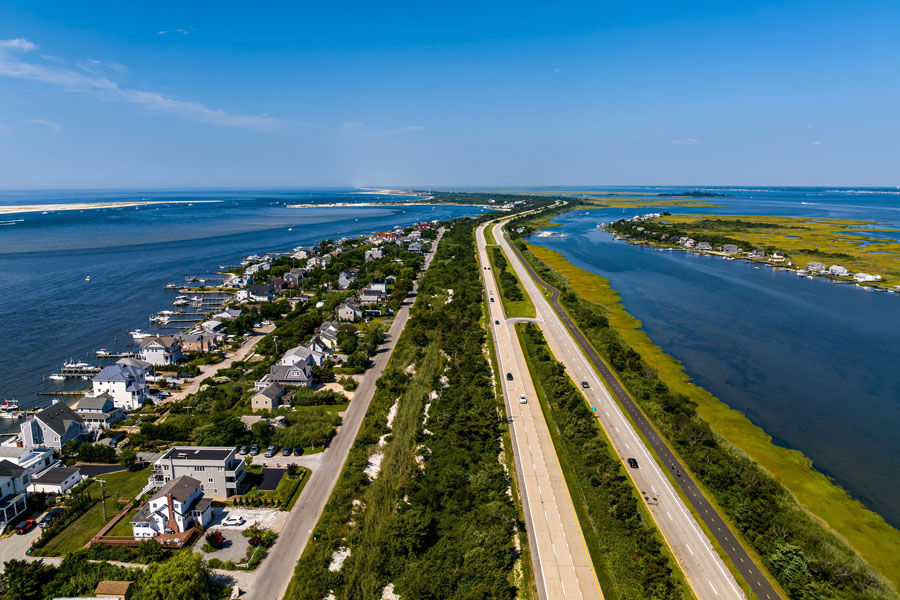
Ocean Parkway is one of Long Island’s South Shore signature coastal drives, running along Jones Beach Island between Jones Beach State Park and the Captree State Park area, where nearby connections continue to the Robert Moses Causeway for access to Robert Moses State Park and western Fire Island. Developed as part of Robert Moses’ larger park and parkway system, the road serves beach fields, marinas, fishing areas, and bayfront access points across this barrier-island corridor. Cyclists and pedestrians can use parallel shared-use paths on portions of the route.
Because Ocean Parkway sits directly on the barrier island, travel conditions can change with weather, sand, flooding, construction, and seasonal beach traffic. Parking rules, fees, and beach access policies also vary by operator and season, so it’s smart to check ahead before visiting.
Route and Features
- Western Hub: Jones Beach State Park, with approach connections via Meadowbrook State Parkway, Wantagh State Parkway, and Bay Parkway
- Eastern Connection: Captree State Park / Robert Moses Causeway area, with onward access toward Robert Moses State Park and Fire Island
- Length: about 15 miles across the main Jones Beach Island corridor
- County Line: Nassau County in the west to Suffolk County in the east
- Vehicle Restrictions: Parkway rules apply; trucks and most commercial vehicles are generally prohibited
- Popular Uses: Beach access, scenic driving, cycling, fishing, surfing, boating, and access to marinas and charter fleets
Access Points (west → east)
Ocean Parkway uses named beach and park turnoffs rather than conventional numbered exits. Parking availability, admission, and residency rules may differ by location.
| Access | Destination / Notes |
|---|---|
| Jones Beach West End Circle | West End beaches, fishing access, and nearby boat basin facilities |
| Jones Beach Parking Fields 1–6 | Main oceanfront parking fields and boardwalk access for Jones Beach State Park |
| Jones Beach Field 10 / Boat Basin | Marina, bay access, and park support facilities |
| Jones Beach Approach Connections | Links with Meadowbrook State Parkway, Wantagh State Parkway, and Bay Parkway for travel to and from Nassau County |
| Tobay Beach | Town of Oyster Bay ocean and bay access, marina area, and seasonal beach facilities |
| Gilgo Beach | Town of Babylon ocean beach known for surf and fishing access |
| Cedar Beach | Town of Babylon beach and marina area with both oceanfront and bay-side access nearby |
| Overlook Beach | Town of Babylon ocean beach and seasonal recreation facilities |
| Captree Island / Captree State Park | Marinas, charter and party-boat fleet, fishing access, and nearby food concessions |
| Robert Moses Causeway Junction | Connection south toward Robert Moses State Park and Fire Island, and north toward NY-27A and other South Shore parkway routes |
Vicinity of Ocean Parkway
Notable Facts
- Ocean Parkway was built to connect motorists to Jones Beach and other South Shore recreation areas along the barrier island.
- The route is especially popular for beachgoing, fishing, boating, birding, and scenic sunrise or sunset drives.
- Parallel shared-use paths make parts of the corridor popular with cyclists, runners, and walkers, especially in fair weather.
- Because it is exposed to coastal conditions, Ocean Parkway is more susceptible than inland roads to temporary closures, sand accumulation, flooding, and storm-related work.
Visitor Tips
- Beach hours, lifeguard coverage, parking fees, and resident access rules vary by park, town beach, and season.
- Services such as concessions, marinas, fishing boats, and restrooms may operate on seasonal schedules.
- Summer weekends can bring heavy traffic, especially around Jones Beach, Tobay Beach, Gilgo Beach, Captree State Park, and major event days.
- Check current road, park, and weather conditions before heading out, particularly after coastal storms or during active dune or roadway work.
