
Meadowbrook State Parkway
The Meadowbrook State Parkway (MSP) is an approximately 12.5-mile north-south parkway in Nassau County that runs from the Northern State Parkway area in the Westbury/Carle Place corridor south to Jones Beach State Park, where it reaches the Ocean Parkway / Bay Parkway interchange. Built as part of Robert Moses‘ Long Island parkway system, it remains one of the main routes to Jones Beach and the South Shore. Along the way, it connects with the Southern State Parkway and major roads including Hempstead Turnpike, Sunrise Highway, Merrick Road, and the Loop Parkway. Exits on the MSP use an “M” prefix and generally increase as you travel south toward Jones Beach.
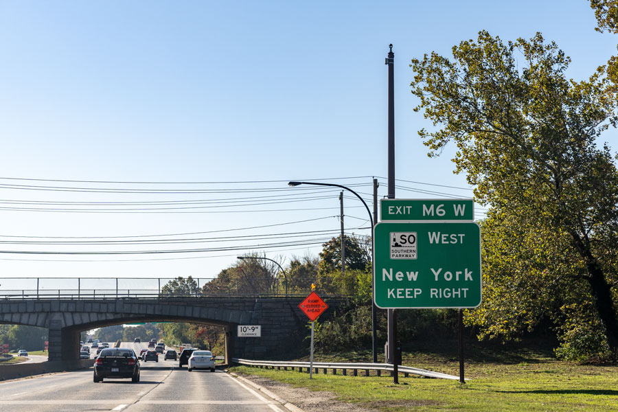
Numbered Exits (north → south)
| Exit | Destination / Roadway | Notes |
|---|---|---|
| M1 | Old Country Rd (CR 25) | Carle Place / Westbury; access near the parkway’s northern end. |
| M2E / M2W | Zeckendorf Blvd (CR 154) / Roosevelt Field | Roosevelt Field and surrounding shopping / business area. |
| M3E / M3W | Merchants Concourse / Stewart Ave (CR 177) | Eisenhower Park and Nassau Hub area. |
| M4 | NY-24 Hempstead Tpke (westbound access) | Toward Hempstead and central Nassau destinations. |
| M5 | NY-24 Hempstead Tpke (eastbound access) | Toward East Meadow and points east. |
| M6W / M6E | Southern State Pkwy — West / East | Major junction; toward Queens to the west and Suffolk County to the east. |
| M7W / M7E | Babylon Turnpike — West / East | Roosevelt / North Merrick area access. |
| M8W / M8E | NY-27 Sunrise Hwy — West / East | Freeport / Merrick corridor. |
| M9W / M9E | Merrick Rd (CR 27) — West / East | Freeport / Merrick; cloverleaf interchange. |
| M10 | Loop Parkway | Access toward Point Lookout and the Long Beach barrier island. |
| — | Ocean Pkwy / Bay Pkwy (Jones Beach) | Southern terminus in the Jones Beach interchange area. |
Exit configurations and ramp movements can change over time, so check posted signs as you drive. After the last numbered exit, the roadway continues a short distance into the Ocean Parkway / Bay Parkway interchange within Jones Beach State Park.
Vicinity of the Meadowbrook
Quick facts
- Length: Approximately 12.5 miles, entirely within Nassau County.
- Northern terminus: Northern State Parkway interchange area in the Westbury/Carle Place corridor, with nearby access to Old Country Road and the broader Long Island Expressway network.
- Southern terminus: Jones Beach State Park at the Ocean Parkway / Bay Parkway interchange.
- Restrictions: Parkway rules apply. Commercial trucks, tractor-trailers, and other oversized or non-parkway-legal vehicles are prohibited; check posted signage before traveling.
- Traffic note: Southbound traffic can be especially heavy on summer weekends, holidays, and major event days at Jones Beach, so extra travel time is a good idea.
Driving note: Services are limited along the parkway itself, and some interchanges use directional ramps rather than full-access movements. If you are heading to the beach, a concert at Jones Beach Theater, or the barrier island communities, it is smart to confirm your route before you go.
