
Quantuck Bay
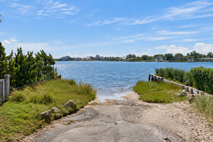
Quantuck Bay is a shallow coastal bay along the South Shore of Long Island in Suffolk County, New York. Located in the Town of Southampton between Westhampton Beach and Quogue, the bay forms part of the interconnected lagoon and canal system linking Moriches Bay with the waters of Shinnecock Bay farther east.
Quantuck Bay is relatively small compared with neighboring Moriches Bay and Shinnecock Bay, but it occupies an important position within Long Island’s South Shore waterway system. The bay is bordered by residential waterfront areas, tidal creeks, marshes and the barrier-beach landscape separating these protected waters from the Atlantic Ocean. Boating, fishing, shellfishing, kayaking and wildlife observation are among the activities associated with the bay and surrounding waterways.
Geography
Quantuck Bay lies along the western portion of the Town of Southampton, near the communities of Westhampton Beach, Quiogue and Quogue.
The New York State Department of Environmental Conservation identifies the entire Quantuck Bay waterbody segment as approximately 256 acres of estuarine waters. Its location places it within the chain of shallow bays, canals, creeks and lagoons extending behind Long Island’s Atlantic barrier beaches.
Unlike an isolated bay, Quantuck Bay is closely connected with neighboring waterways. To the west, waterways lead toward Moriches Bay. To the east, Quogue Canal continues toward western Shinnecock Bay. Together these waterways form part of a continuous protected route behind the barrier island.
Between Moriches Bay and Shinnecock Bay
One of the defining characteristics of Quantuck Bay is its position between two much larger South Shore bays.
Moriches Bay lies to the west, while Shinnecock Bay lies to the east. Scientific descriptions of Quantuck Bay characterize it as a small, shallow lagoon situated between the two bay systems.
The waterways are connected through a network that includes Moneybogue Bay, Quantuck Canal, Quantuck Creek, Quantuck Bay and Quogue Canal. Although the individual names identify distinct local sections, the water moves through a much larger interconnected South Shore estuarine system.
This geography allows recreational boaters to travel between the Moriches and Shinnecock areas without entering the open Atlantic Ocean.
Quantuck Creek and Nearby Tributaries
Quantuck Creek is one of the principal waterways associated with Quantuck Bay. The creek extends northward from the bay toward the Quiogue and Westhampton Beach area and includes smaller tributaries and shoreline wetlands.
Aspatuck Creek is another important tributary within the Quantuck Bay watershed. The Town of Southampton has identified the Aspatuck Creek headwaters as an environmentally significant area draining toward Quantuck Bay and the larger South Shore Estuary Reserve system.
These creeks help connect inland freshwater and groundwater drainage with the tidal bay environment. Their surrounding wetlands and wooded areas also contribute habitat and natural filtration within the watershed.
Quogue Canal
At the eastern side of Quantuck Bay, Quogue Canal continues toward the western portion of Shinnecock Bay.
The canal passes through the Quogue area behind the Atlantic barrier beach and forms an important part of the sheltered east-west navigation route through this section of Long Island’s South Shore.
New York shellfish management regulations commonly group Quantuck Bay with neighboring Moneybogue Bay, Quantuck Canal and Quogue Canal, reflecting the close environmental connection among these waters.
Long Island Intracoastal Waterway
Quantuck Bay is part of the route followed by the Long Island Intracoastal Waterway, a federally maintained navigation channel extending through many of Long Island’s protected South Shore bays.
The U.S. Army Corps of Engineers describes the federal waterway as approximately 33.6 miles long, running through Great South Bay, Bellport Bay, Narrow Bay, Moriches Bay, Quantuck Bay and Shinnecock Bay before reaching the Shinnecock Canal area.
The maintained route provides boaters with a sheltered alternative to traveling offshore in the Atlantic Ocean and connects numerous creeks, coves, marinas and waterfront communities along the way.
Boating
Boating is one of the principal recreational uses of Quantuck Bay and its connected waterways.
The bay’s position along the protected South Shore route allows boaters to travel west toward Moriches Bay or east toward Quogue and Shinnecock Bay. The surrounding waterfront also includes private docks, residential canals and access to nearby marinas.
Quantuck Bay and the surrounding canals are shallow waterways, so boaters should follow marked channels and consult current nautical charts, tides and navigation information. Shoaling and local bottom conditions can change, particularly throughout Long Island’s dynamic South Shore estuary system.
Fishing
Fishing has long been associated with the protected bays and tidal creeks of Long Island’s South Shore, including Quantuck Bay.
The bay’s shallow estuarine environment and connections with Moriches and Shinnecock bays provide habitat used by a variety of marine species. Anglers may encounter species common to eastern Long Island’s South Shore waters, although abundance and fishing opportunities vary considerably by season.
Anyone fishing the area should consult current New York recreational saltwater fishing regulations, size limits, seasons and registration requirements before heading out.
Shellfishing
Shellfish habitat is an important part of Quantuck Bay, but harvesting is subject to detailed New York State water-quality classifications and seasonal restrictions.
The New York State Department of Environmental Conservation specifically regulates Quantuck Bay, Quantuck Creek, Aspatuck Creek, Quantuck Canal, Moneybogue Bay and Quogue Canal as part of the surrounding shellfish management area. Certain canals, tributaries and shoreline areas are closed year-round, while broader areas may be subject to seasonal classifications.
Temporary emergency closures can also occur because of rainfall, sewage discharges, harmful algal blooms or other water-quality conditions. Anyone planning to harvest clams, oysters or other shellfish should check the current NYSDEC shellfish closure information immediately before harvesting.
Kayaking and Paddleboarding
The protected character of Quantuck Bay can make the area attractive for kayaking and paddleboarding.
Paddlers can encounter tidal creeks, marsh-lined shorelines, residential waterfronts and broader open sections of the bay. Conditions can still change quickly because of wind, tides, boat wakes and currents through the connecting canals.
Much of the immediate shoreline is residential or otherwise privately controlled, so paddlers should use established legal access points rather than assuming shoreline access is public.
Wetlands and Coastal Habitat
Quantuck Bay is surrounded in part by tidal wetlands, marshes, creeks and other shallow-water habitats characteristic of Long Island’s South Shore estuaries.
These habitats provide feeding, nursery and shelter areas for fish, shellfish, waterfowl and other coastal wildlife. Marshes and undeveloped shoreline areas also help absorb stormwater, trap sediment and reduce some of the impacts of coastal flooding and erosion.
The bay lies within the broader South Shore Estuary Reserve, the extensive network of bays, wetlands, barrier beaches and watersheds extending across much of Long Island’s southern coastline.
Its creeks and wetlands also provide opportunities for birdwatching and wildlife observation, particularly around quieter marsh and creek environments.
Water Quality and Brown Tide
Quantuck Bay has also played an important role in Long Island water-quality and harmful algal bloom research.
The Suffolk County Department of Health Services has monitored Quantuck Bay and other South Shore embayments for decades. Quantuck Bay has experienced repeated blooms of brown tide, caused by the microscopic alga Aureococcus anophagefferens. Brown tide was first documented in Suffolk County waters in 1985 and has periodically affected Quantuck Bay, Moriches Bay, Shinnecock Bay and other Long Island estuaries.
Researchers have repeatedly used Quantuck Bay as a study site because of its history of brown tide blooms. High concentrations of the organism can reduce light penetration and negatively affect shellfish and other components of the estuarine ecosystem.
NYSDEC currently identifies the entire 256-acre Quantuck Bay segment as an impaired waterbody. State assessments have identified concerns involving nitrogen, dissolved oxygen, fecal coliform bacteria and excessive algal or aquatic-plant growth. Water-quality classifications and conditions can change over time as monitoring and restoration efforts continue.
Nearby Communities
Quantuck Bay is closely associated with several communities in the western portion of the Town of Southampton.
Westhampton Beach lies immediately west and northwest of the bay and serves as one of the principal commercial and recreational centers in the area. The small community of Quiogue occupies waterfront land near Quantuck Creek and the western side of the bay.
The incorporated Village of Quogue borders the eastern side of the bay and the waterways leading into Quogue Canal. Farther east are East Quogue and the larger Shinnecock Bay region.
The surrounding area is generally considered part of the western Hamptons, combining year-round residential neighborhoods with seasonal homes, ocean beaches and an active summer boating and waterfront culture.
Quantuck Bay within Long Island’s Waterway System
Quantuck Bay is a relatively small waterbody, but geographically it is an important link in the chain of South Shore bays extending across Suffolk County.
To the west, the connected waterways reach Moriches Bay, which connects with the Atlantic through Moriches Inlet. To the east, Quogue Canal leads toward Shinnecock Bay and ultimately the waterways surrounding Hampton Bays and Shinnecock Inlet.
Its inclusion within the federal Intracoastal Waterway, the South Shore Estuary Reserve and state shellfish and water-quality management programs reflects Quantuck Bay’s continuing importance as both a navigable coastal waterway and an environmentally sensitive estuarine habitat.
Quantuck Bay
Key Facts & Details
| Feature | Details |
|---|---|
| Waterway | Quantuck Bay within Long Island’s bays, harbors, inlets and waterways system |
| Location | South Shore of Long Island |
| County | Suffolk County, New York |
| Town | Town of Southampton |
| Nearby Communities | Westhampton Beach, Quiogue and Quogue |
| Waterway Type | Shallow coastal bay and estuary |
| Approximate Size | 256 acres according to NYSDEC waterbody assessment records |
| Western Connection | Quantuck Creek, Quantuck Canal and waterways leading toward Moriches Bay |
| Eastern Connection | Quogue Canal and western Shinnecock Bay |
| Major Tributaries | Quantuck Creek and Aspatuck Creek |
| Navigation System | Part of the Long Island Intracoastal Waterway route |
| Larger Estuary | South Shore Estuary Reserve |
| Atlantic Connection | Indirectly through neighboring South Shore bays and inlets, including Moriches Inlet and Shinnecock Inlet |
| Major Habitats | Shallow estuarine water, tidal creeks, salt marshes, wetlands and shellfish habitat |
| Popular Activities | Boating, fishing, shellfishing, kayaking, paddleboarding and birdwatching |
| Boating Resources | Long Island marinas and boat slips and marinas |
| Fishing Resources | Long Island fishing, fishing piers and fishing charters |
| Shellfish Regulation | NYSDEC maintains seasonal and year-round shellfish closures in portions of Quantuck Bay and adjacent waterways |
| Water Quality | NYSDEC currently identifies the Quantuck Bay segment as impaired |
| Environmental History | Long-term monitoring site known for recurring brown tide blooms |
| Known For | Protected South Shore waters, boating, tidal creeks, wetlands, shellfish habitat and its location between the Moriches and Shinnecock bay systems |
| Related Waterways Guide | Bays, Harbors, Inlets & Waterways of Long Island |
Quantuck Bay is a small but important part of Long Island’s interconnected South Shore estuary. Positioned between Moriches Bay and Shinnecock Bay, the bay combines navigable waterways, tidal creeks, wetlands, shellfish habitat and residential waterfronts within the western Town of Southampton. Its role in the Long Island Intracoastal Waterway and South Shore Estuary Reserve, together with decades of environmental monitoring, makes Quantuck Bay a significant geographic and ecological link within eastern Suffolk County’s coastal waterway system.
Are you ready for fall on Long Island? Check out these local seasonal guides:
🍎 Apple Picking | 🍂 Fall Festivals & Farm Activities | 👻 Haunted Houses | 🎃 Pumpkin Picking
