
Lake Montauk
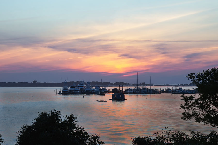
Lake Montauk is a large tidal body of water on the northeastern side of Montauk, near the eastern end of Long Island’s South Fork. Covering approximately 900 acres, the lake is surrounded by marinas, fishing docks, residential shoreline, wetlands and marine businesses and forms one of the defining features of Montauk’s maritime landscape. Despite its name, Lake Montauk is no longer a freshwater lake. Since 1927, it has been connected to Block Island Sound, making it a tidal saltwater embayment and an important center for fishing, boating and marine activity on Long Island’s East End.
The transformation of Lake Montauk is one of the more unusual chapters in the history of the Hamptons. Originally known as the Great Lake, it was once the largest freshwater body on Long Island. Developer Carl G. Fisher permanently changed the lake when he opened its northern shoreline to the sea in 1927 as part of an ambitious plan to transform Montauk into a major resort and maritime destination.
About Lake Montauk
Lake Montauk occupies a broad area east and northeast of downtown Montauk in the Town of East Hampton, Suffolk County. East Lake Drive follows much of the lake’s eastern side, while West Lake Drive serves the western shoreline and the busy harbor district. Star Island extends into the northern part of the lake near its connection with Montauk Inlet.
The character of the lake changes considerably from north to south. The northern portion is closely associated with Montauk Harbor, commercial fishing, charter boats, marinas and marine businesses. Farther south, the shoreline becomes quieter and more residential, with wetlands, shallow coves and stretches of open water that feel removed from the activity of the working harbor.
Lake Montauk is tidal, so its water level, currents and marine conditions are influenced by the surrounding coastal waters. Boats traveling between the lake and the open sea pass through Montauk Inlet before entering Block Island Sound, providing direct access to the waters around Montauk Point and the Atlantic Ocean.
From the Great Lake to a Saltwater Harbor
For centuries, the waterway now known as Lake Montauk was separated from the sea. Known historically as the Great Lake, it was a freshwater lake cut off from Block Island Sound by a narrow strip of land along Montauk’s northern shoreline.
That changed during the development boom of the 1920s. Carl G. Fisher, a prominent developer who had already played an important role in the growth of Miami Beach, acquired thousands of acres in Montauk and envisioned turning the remote eastern tip of Long Island into an upscale resort community. His plans called for hotels, residences, recreational facilities, roads, clubs and a modern harbor capable of accommodating yachts and commercial vessels.
In 1927, Fisher had a channel opened through the land separating the Great Lake from Block Island Sound. Salt water entered the lake, tides began flowing through the new inlet and the freshwater ecosystem was permanently converted into a marine environment. The project also created a sheltered harbor with direct access to the surrounding coastal waters.
Fisher’s larger plans for Montauk were disrupted by the economic collapse that followed the stock market crash of 1929, but the new harbor endured. Over time, Lake Montauk became increasingly important to commercial fishing, charter fishing and recreational boating, establishing the waterfront economy that continues to define the northern end of the lake.
Lake Montauk and Montauk Harbor
Lake Montauk and Montauk Harbor are closely connected, but the terms are not quite identical. Lake Montauk refers to the entire body of water, including its quieter southern reaches. Montauk Harbor generally refers to the working maritime area concentrated around the northern portion of the lake, Star Island and the inlet.
This helps explain why maps, nautical references, businesses and government documents sometimes use names such as Lake Montauk Harbor, Montauk Harbor, Montauk Lake or Lake Montauk. In most cases, they are describing different aspects of the same connected harbor system rather than separate bodies of water.
The northern waterfront contains much of the area’s marine infrastructure, including docks, boatyards, fuel facilities and many of the businesses that support Montauk’s fishing and recreational boating industries. Visitors looking for boat slips and related facilities can also see our guide to marinas on Long Island.
Montauk Inlet and Access to the Sea
The northern entrance to Lake Montauk is Montauk Inlet, the navigable channel connecting the lake with Block Island Sound. Protected by stone jetties, the inlet serves commercial fishing boats, charter vessels, recreational boaters and government vessels and is critical to maintaining Montauk’s role as a working harbor.
Sand naturally moves along the coast and can accumulate within the navigation channel, so periodic dredging is necessary to keep the inlet open and sufficiently deep for larger vessels. The U.S. Army Corps of Engineers has maintained the federal navigation project at Lake Montauk Harbor for decades.
In 2026, the Army Corps and Town of East Hampton completed a major navigation improvement that deepened the channel from approximately 12 feet to approximately 17 feet. Roughly 87,000 cubic yards of sand and approximately 10,000 cubic yards of clay were removed. The project was intended to improve navigation for commercial vessels, recreational boats and Coast Guard operations while reducing problems caused by shoaling.
Fishing at Lake Montauk
Fishing is one of the defining activities associated with Lake Montauk. The harbor supports commercial fishing vessels, charter boats, party boats, recreational anglers and a network of marine businesses tied to the fishing industry. Boats based inside the lake have relatively quick access to Block Island Sound, Montauk Point and offshore waters.
The surrounding Montauk fishing grounds are associated with striped bass, bluefish, fluke, black sea bass, cod, tuna and numerous other inshore and offshore species depending on the season. Anglers planning a trip can find additional information in our guide to fishing on Long Island, including regulations and seasonal considerations.
Montauk is also one of Long Island’s major charter fishing destinations. Visitors who do not have their own boat can explore options through our guide to chartering a fishing boat on Long Island.
Anyone fishing recreationally should verify current New York State licensing and registration requirements before heading out. Our guide explaining Long Island fishing license requirements provides a starting point for understanding when permits or marine registrations may apply.
Boating on Lake Montauk
Lake Montauk is heavily used by recreational boaters in addition to the commercial fleet. Its protected interior waters provide access to docks, slips and marinas, while Montauk Inlet opens directly toward Block Island Sound and the Atlantic approaches surrounding Montauk Point.
Visitors interested in getting onto the water can also consult our guide to boating and boat rentals on Long Island. Conditions outside the inlet can be very different from those within the lake, particularly when wind, tides, currents, fog or ocean swell are present.
A municipal hard-surface boat launch provides access to Lake Montauk and Block Island Sound. The New York State Department of Environmental Conservation lists parking for approximately 25 cars and trailers and notes that a fee or permit is required. Visitors should check current Town of East Hampton rules before arrival because permit requirements and seasonal procedures can change.
Kayaking and Paddlecraft
The quieter southern areas of Lake Montauk can appeal to kayakers and other paddlers, particularly when weather and tidal conditions are favorable. Visitors interested in exploring additional launch locations can see our guide to kayaking on Long Island or our guide to paddleboarding on Long Island.
Paddlers should remember that Lake Montauk is not simply a quiet recreational lake. It is an active tidal harbor used by large commercial and recreational vessels, particularly toward its northern end. Wind and current can also change quickly, and anyone using a small paddlecraft should remain well clear of navigation channels and busy marina areas.
Star Island
Star Island occupies a prominent position near the northern end of Lake Montauk and is closely associated with the development of the harbor. It sits within the lake near Montauk Inlet, surrounded by the area’s busiest concentration of marine activity.
Carl Fisher placed considerable importance on Star Island as part of his vision for Montauk as a yachting and resort destination. Today, the island and surrounding waterfront remain strongly associated with marinas, boating and Coast Guard operations.
One of the area’s more unusual landmarks is the Montauk Yacht Club Lighthouse, a distinctive waterfront structure overlooking the harbor area from Star Island.
South Lake Montauk and the Quieter Shoreline
The southern portion of Lake Montauk offers a much quieter setting than the commercial harbor to the north. The surrounding shoreline contains residential properties, wetlands, shallow coastal habitat and less intensive marine development.
The Town of East Hampton has worked on improvements associated with South Lake Montauk Park, including concepts for seating, bicycle and kayak racks, informational signs and trail information. The area highlights an important aspect of the lake that can easily be overlooked by visitors who experience only Montauk’s busy working waterfront.
Wildlife, Wetlands and Water Quality
Lake Montauk’s tidal waters, wetland edges and surrounding coastal habitat support fish, shellfish and a variety of shorebirds and waterfowl. Ospreys, gulls, terns and cormorants are common around the Montauk waterfront, while the lake forms part of a much larger marine ecosystem extending through Block Island Sound and the waters around Montauk Point.
The opening of the lake to the sea dramatically changed its ecology. A formerly freshwater environment became tidal and saline, allowing marine species to occupy the lake while changing the plants and wildlife associated with its shoreline.
Shellfishing is regulated by the New York State Department of Environmental Conservation, and portions of Montauk Lake and Montauk Harbor may be subject to seasonal or year-round shellfish closures. Anyone interested in harvesting shellfish should verify current regulations before entering the water. Our guide to oyster harvesting on Long Island provides additional background on shellfish harvesting and regulation around the Island.
Restaurants and the Working Waterfront
The harbor district surrounding the northern end of Lake Montauk is also one of the area’s dining centers. Restaurants overlooking the water often sit only a short distance from marinas, charter docks and commercial fishing operations, giving this part of Montauk a noticeably nautical atmosphere.
Visitors looking for dining options can browse our guides to seafood restaurants and waterfront restaurants on Long Island. Montauk’s close relationship with commercial fishing also makes seafood a particularly natural part of the local dining scene.
Visiting Lake Montauk
Lake Montauk is not a conventional attraction with one entrance, parking lot or visitor center. It is a large working waterway surrounded by public roads, private homes, marinas, restaurants and commercial properties. Visitors experience different parts of the lake from East Lake Drive, West Lake Drive, Star Island Road and the Montauk Harbor area.
The northern portion is the best choice for visitors interested in fishing vessels, marinas and Montauk’s working waterfront. The southern and eastern shores are quieter, but much of the immediate waterfront is privately owned. Visitors should not assume that an undeveloped-looking stretch of shoreline is open for public access.
Travelers staying overnight can browse our directory of Long Island hotels and resorts, while those arriving by air may also be interested in Montauk Airport, a small airport located just east of the lake.
Nearby Montauk Parks and Attractions
Lake Montauk sits within one of the most attraction-rich parts of eastern Long Island. To the east, the landscape becomes increasingly rugged as visitors approach Montauk Point State Park and the historic Montauk Point Lighthouse. Nearby Camp Hero State Park preserves former military installations along with coastal woodland and bluff-top scenery.
Closer to the center of Montauk, Shadmoor State Park protects oceanfront bluffs and hiking trails, while Ditch Plains Beach is one of the area’s best-known surfing destinations. Golfers and outdoor visitors can also explore Montauk Downs State Park.
West of Montauk, Hither Hills State Park offers ocean beach, camping and extensive natural areas, while Napeague State Park and Amsterdam Beach State Park preserve additional stretches of the East End’s coastal landscape.
Continuing west leads toward Napeague and Amagansett before reaching the central communities of East Hampton. These places make Lake Montauk a natural stop within a larger exploration of the eastern South Fork rather than an isolated destination.
Lake Montauk and Block Island
The connection between Lake Montauk and Block Island Sound also places the harbor along an important regional boating route. Block Island lies offshore to the northeast and has long been connected with Montauk through fishing, recreational boating and seasonal passenger travel.
Visitors considering an offshore excursion can learn more in our guide to the Block Island Ferry. The relationship between Montauk Harbor, Block Island Sound and the surrounding Atlantic waters is one reason Lake Montauk developed into such an important marine center despite its relatively remote location at the eastern edge of Long Island.
Sunsets and Scenic Views
Although Montauk is famous for its ocean beaches and sunrise views, Lake Montauk can also be particularly scenic late in the day. Boats, docks and shoreline silhouettes often reflect across the protected water as the evening light changes above the harbor.
Travelers looking for other scenic locations around the Island can also see our guides to the best sunset spots on Long Island, places to watch the sunrise and places for photography.
Lake Montauk Today
Nearly a century after the Great Lake was opened to the sea, Lake Montauk remains one of the clearest examples of how human engineering reshaped the geography and economy of Long Island’s East End. What had been an isolated freshwater lake became a tidal harbor capable of supporting commercial fishing, offshore charter fleets, marinas, recreational boating and maritime services.
At the same time, Lake Montauk remains more than a harbor. Its quieter coves, wetlands, residential shoreline and broad open water form an important part of Montauk’s natural landscape. The combination of working waterfront, recreational waterway, marine habitat and unusual history gives the lake an identity that is distinct from both downtown Montauk and the dramatic ocean shoreline at Montauk Point.
Lake Montauk
Key Facts & Details
| Location | Montauk, Town of East Hampton, Suffolk County, New York |
| Region | South Fork, East End of Long Island |
| Type | Tidal saltwater embayment and harbor |
| Approximate Size | 900 acres |
| Historic Name | Great Lake |
| Original Environment | Freshwater lake |
| Connection to Sea | Opened to Block Island Sound in 1927 |
| Developer Associated With Transformation | Carl G. Fisher |
| Connected Water | Block Island Sound through Montauk Inlet |
| Primary Uses | Commercial fishing, charter fishing, recreational boating, marine services and waterfront recreation |
| Major Geographic Feature | Star Island |
| Public Boat Access | Municipal hard-surface boat launch; current permit or fee requirements should be checked before visiting |
| Navigation | Federal navigation channel maintained through Montauk Inlet |
| 2026 Channel Improvement | Channel deepened from approximately 12 feet to approximately 17 feet |
| Nearby Areas | Montauk Harbor, Montauk Point, Ditch Plains, Napeague and Amagansett |
Lake Montauk tells a story unlike almost any other major body of water on Long Island. Once the Island’s largest freshwater lake, it was deliberately opened to the sea in 1927 and transformed into the tidal harbor that helped shape modern Montauk. Today its fishing fleet, marinas, inlet, wetlands and quieter southern shoreline make Lake Montauk both a working maritime center and an important part of the natural landscape at the eastern end of Long Island.
Are you ready for fall on Long Island? Check out these local seasonal guides:
🍎 Apple Picking | 🍂 Fall Festivals & Farm Activities | 👻 Haunted Houses | 🎃 Pumpkin Picking
