
The East River
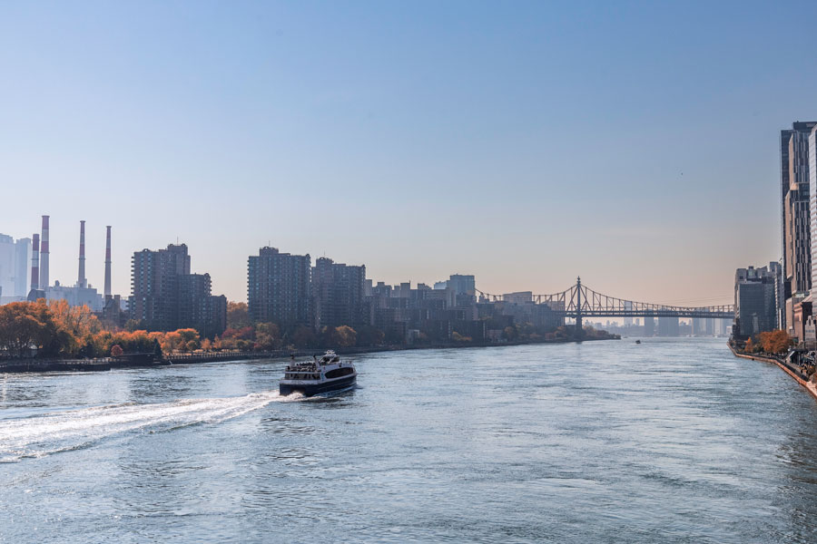
The East River is a tidal strait in New York City that separates the western end of Long Island from Manhattan and parts of the Bronx. Extending between Upper New York Bay and Long Island Sound, the waterway passes alongside Brooklyn, Queens, Manhattan, and several islands while supporting bridges and tunnels, ferries, commercial vessels, waterfront parks, and recreational activity.
Despite its name, the East River is not a true river. It does not begin at inland headwaters or flow steadily toward a single mouth. Its currents move in changing directions with the tides, carrying water between New York Harbor and the western end of Long Island Sound.
Where Is the East River?
The East River begins near Upper New York Bay at the southern end of Manhattan and extends northward before reaching Long Island Sound. Along the way, it separates Manhattan from Brooklyn and Queens and separates portions of Queens from the Bronx.
Brooklyn and Queens are geographically located on Long Island, even though they are politically part of New York City. This makes the East River one of Long Island’s most important geographic boundaries. The waterway separates Long Island from Manhattan while also providing the western connection between Long Island Sound and New York Harbor.
Is the East River Actually a River?
The East River is technically a tidal strait, which is a relatively narrow waterway connecting two larger bodies of water. Its flow is controlled primarily by the tides rather than by water traveling continuously downhill from a source.
As tidal conditions change, currents in the East River can reverse direction and vary considerably in speed. The narrowing of the waterway around islands, bridge supports, shoreline structures, and passages such as Hell Gate can produce particularly strong and complicated currents.
Why Is It Called the East River?
The name dates to the Dutch colonial period, when the waterway was known as the Oost Rivier, meaning East River. It was located east of the settlement at the southern end of Manhattan, while the Hudson River was known as the North River.
The English name remained in use after control of the colony changed, even though later geographic and scientific descriptions classified the waterway as a tidal strait rather than a conventional river.
The East River and Long Island
The East River plays an important role in explaining Long Island’s geography. Brooklyn and Queens occupy the island’s western end, while Nassau County and Suffolk County extend eastward beyond the New York City boundary. The East River forms the western shoreline of Brooklyn and Queens and physically separates these parts of Long Island from Manhattan.
Many of the transportation routes connecting Long Island with Manhattan cross above or below the East River. These crossings carry automobiles, trucks, subway trains, commuter trains, bicycles, pedestrians, utility lines, and other infrastructure that helps connect Long Island with the rest of the New York metropolitan region.
Hell Gate
Hell Gate is a narrow and historically difficult section of the East River between Astoria in Queens and Wards Island. The passage is located near the meeting point of the East River, Harlem River, and Long Island Sound.
The area was once known for dangerous rocks, whirlpools, and powerful tidal currents that made navigation especially hazardous. Large engineering projects during the nineteenth century removed many underwater obstructions and widened navigable channels, although strong and rapidly changing currents remain a defining characteristic of the passage.
Islands in the East River
Several islands are located within or along the East River, each with a different history and modern use.
- Roosevelt Island lies between Manhattan and Queens and contains residential neighborhoods, parks, historic structures, and Franklin D. Roosevelt Four Freedoms Park.
- Randalls and Wards Islands form a connected park and recreation area near the meeting of the East River, Harlem River, and Long Island Sound.
- Rikers Island is located near the northern end of the waterway between Queens and the Bronx and is occupied by New York City’s jail complex.
- North Brother Island and South Brother Island are located between Queens and the Bronx and have important natural and historical significance.
- U Thant Island is a small artificial island near the southern end of Roosevelt Island.
- Mill Rock is a small island near the Manhattan shoreline and the western entrance to Hell Gate.
Bridges Across the East River
Some of New York City’s most recognizable bridges cross the East River, connecting Brooklyn and Queens with Manhattan or linking Queens with the Bronx.
- Brooklyn Bridge connects Lower Manhattan with Downtown Brooklyn.
- Manhattan Bridge connects Lower Manhattan with Brooklyn and carries road traffic, subway trains, bicycles, and pedestrians.
- Williamsburg Bridge connects Manhattan’s Lower East Side with Williamsburg in Brooklyn.
- Queensboro Bridge connects Midtown Manhattan with Long Island City in Queens and passes over Roosevelt Island.
- Robert F. Kennedy Bridge, historically known as the Triborough Bridge, connects Manhattan, Queens, and the Bronx through Randalls and Wards Islands.
- Hell Gate Bridge carries rail traffic between Queens and the Bronx across Hell Gate.
- Roosevelt Island Bridge connects Roosevelt Island with Queens.
Several smaller bridges also cross channels associated with Randalls and Wards Islands, while pedestrian and bicycle routes provide additional ways to experience portions of the East River waterfront.
Tunnels Beneath the East River
A large network of vehicular, subway, railroad, utility, and service tunnels passes beneath the East River. These tunnels are essential to travel between Long Island and Manhattan, particularly for residents and commuters traveling from Brooklyn, Queens, Nassau County, and Suffolk County.
The Queens-Midtown Tunnel carries vehicular traffic between Long Island City and Midtown Manhattan. The Hugh L. Carey Tunnel, formerly known as the Brooklyn-Battery Tunnel, connects Brooklyn with Lower Manhattan.
Multiple New York City Subway routes also cross beneath the East River, as do railroad tunnels used by the Long Island Rail Road and Amtrak. These underwater connections allow passengers to travel between Long Island and Manhattan without using a bridge or ferry.
Ferries and Water Transportation
Passenger ferries have crossed the East River since long before the construction of its bridges and tunnels. Ferry transportation declined as fixed crossings expanded, but modern ferry service has restored many connections among waterfront communities.
NYC Ferry routes serve landings in Manhattan, Brooklyn, Queens, Roosevelt Island, and the Bronx. Ferries provide an alternative to road and subway travel while offering views of the Manhattan skyline, waterfront neighborhoods, islands, and major bridges.
Sightseeing boats, harbor cruises, private vessels, water taxis, government boats, workboats, and commercial traffic also travel through the East River. Mariners must account for changing tides, heavy vessel activity, bridge clearances, and strong currents.
Waterfront Parks and Recreation
The shoreline of the East River includes parks, promenades, greenways, piers, playgrounds, overlooks, and restored waterfront areas. These public spaces have transformed portions of the former industrial shoreline into destinations for walking, cycling, sightseeing, photography, fishing, and outdoor recreation.
Notable waterfront destinations include Brooklyn Bridge Park, Domino Park, Gantry Plaza State Park, Hunter’s Point South Park, Astoria Park, Roosevelt Island, East River Park, and portions of the Manhattan waterfront greenway. The views vary considerably, ranging from the historic bridges near Lower Manhattan to the islands and broad channels near Hell Gate.
Kayaking, rowing, sailing, and other activities take place in designated or professionally supervised areas. Because currents can be powerful and marine traffic is frequent, entering the water without suitable experience, equipment, and local guidance can be dangerous.
Shipping and Maritime History
The East River helped shape the commercial development of New York City and western Long Island. Its shoreline once contained extensive shipyards, warehouses, factories, ferry terminals, power facilities, and industrial piers. Vessels used the waterway to move between New York Harbor, Long Island Sound, coastal New England, and other ports.
Although many former industrial properties have been converted into parks and residential or commercial developments, the East River remains an active navigable waterway. Barges, tugboats, ferries, government vessels, construction equipment, and recreational boats continue to share the channel.
Water Quality and Wildlife
The East River is part of the larger New York-New Jersey Harbor Estuary. Its water reflects the mixing of harbor water, tidal water from Long Island Sound, freshwater runoff, and discharges from the surrounding urban environment.
Pollution, sewage discharges, shoreline development, and industrial activity caused major environmental problems during earlier periods of the city’s history. Wastewater treatment improvements, environmental regulation, shoreline restoration, and habitat projects have since improved many conditions, although water-quality challenges remain.
Fish, crabs, shellfish, marine mammals, and numerous bird species may be observed in or near the waterway. Gulls, cormorants, herons, egrets, and other coastal birds are common along portions of the shoreline, while migrating fish use the connected waters of New York Harbor and Long Island Sound.
Key Facts & Details
| Feature | Details |
|---|---|
| Waterway Type | Tidal strait |
| Location | New York City, between Long Island and Manhattan and portions of the Bronx |
| Approximate Length | About 16 miles |
| Southern Connection | Upper New York Bay and New York Harbor |
| Northern Connection | Long Island Sound |
| Areas Along the Waterway | Brooklyn, Queens, Manhattan, and the Bronx |
| Important Passage | Hell Gate |
| Major Islands | Roosevelt Island, Randalls and Wards Islands, Rikers Island, North Brother Island, South Brother Island, Mill Rock, and U Thant Island |
| Major Bridge Crossings | Brooklyn Bridge, Manhattan Bridge, Williamsburg Bridge, Queensboro Bridge, Robert F. Kennedy Bridge, Hell Gate Bridge, and Roosevelt Island Bridge |
| Major Vehicular Tunnels | Queens-Midtown Tunnel and Hugh L. Carey Tunnel |
| Current Direction | Changes with tidal conditions |
| Primary Uses | Transportation, navigation, ferry service, recreation, waterfront access, and maritime commerce |
| Importance to Long Island | Forms part of Long Island’s western geographic boundary and carries major transportation connections between Long Island and Manhattan |
The East River is one of the defining waterways of both Long Island and New York City. It forms a major geographic boundary, connects Long Island Sound with New York Harbor, and supports transportation routes used by millions of people throughout the metropolitan region. Its bridges, tunnels, ferries, islands, waterfront parks, maritime history, and changing tidal currents make the East River an essential part of understanding the geography and development of western Long Island.
Are you ready for fall on Long Island? Check out these local seasonal guides:
🍎 Apple Picking 🍓 Strawberry Picking 🎃 Pumpkin Picking 👻 Haunted Houses 🍂 Farm Festivals
