
New York Harbor
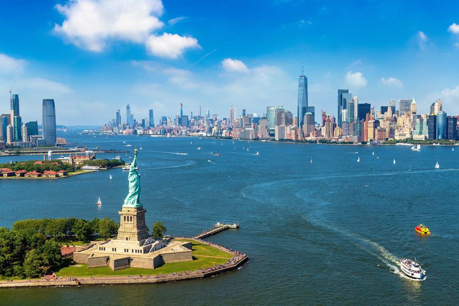
New York Harbor is one of the world’s great natural harbors and the maritime heart of the New York metropolitan region. This broad estuarine gateway helped shape the development of New York City and the surrounding region, including Long Island, for more than four centuries.
For Long Islanders, the harbor is more than a famous body of water to the west. It represents trade, immigration, military history, transportation, and environmental recovery on a regional scale. Its waters connect western Long Island to Manhattan, Staten Island, Brooklyn, Queens, New Jersey, and the Atlantic beyond.
Today, New York Harbor remains one of the nation’s busiest port environments while also serving as a place of recreation, sightseeing, ecological restoration, and public waterfront access. Conditions, ferry service, park hours, and visitor procedures can change, so it is wise to check ahead before making a special trip.
Geography and Formation: Where Rivers Meet the Sea
New York Harbor is part of the larger New York–New Jersey Harbor Estuary, also called the Hudson–Raritan Estuary. This intricate network of bays, tidal straits, marshes, channels, and rivers forms a brackish environment where freshwater from inland watersheds mixes with saltwater from the Atlantic Ocean.
The harbor system is fed primarily by the Hudson River, with additional freshwater entering from New Jersey rivers including the Hackensack, Passaic, Rahway, and Raritan. Smaller tributaries and urban waterways also influence water quality, tides, and habitat conditions throughout the estuary.
Upper and Lower Bays
The harbor is divided into two principal sections connected by the Narrows. Upper New York Bay, often what people mean when they say “New York Harbor,” is enclosed by Manhattan, Brooklyn, Staten Island, and the New Jersey waterfront. Its sheltered waters historically made it ideal for anchorage, trade, and navigation.
Lower New York Bay extends south from the Narrows toward the Atlantic Ocean and is bounded in part by Sandy Hook, New Jersey, and Rockaway Point in Queens. This outer bay includes connected waters such as Raritan Bay and serves as the marine approach to the inner harbor.
The Narrows, the strait between Staten Island and Brooklyn, is the only deep-draft entrance for large oceangoing vessels entering the inner harbor. It is spanned by the iconic Verrazzano-Narrows Bridge, one of the defining landmarks of the region.
Islands of the Harbor
Several notable islands stand within or just beside the harbor system. Liberty Island, home to the Statue of Liberty, and Ellis Island, site of the historic federal immigration station, are the best known. Governors Island occupies a strategic position near the southern end of Manhattan and today functions as a seasonal public destination with parkland, cultural programming, and historic buildings.
Smaller islands, reefs, and artificial structures also play an important part in the harbor’s geography. Long before modern dredging and waterfront construction, the estuary supported extensive oyster reefs that helped define the shoreline and sustain a rich marine ecosystem.
Connected Waterways
Upper New York Bay connects to several other major waterways. To the west, the Kill Van Kull links the harbor to Newark Bay and the container terminals of the Port of New York and New Jersey. To the south and southwest, the Arthur Kill runs between Staten Island and New Jersey and connects with Newark Bay and Raritan Bay.
To the northeast, the East River – despite its name, a tidal strait rather than a true river – connects the harbor with Long Island Sound. Its strong tidal currents and narrow passages have shaped transportation, waterfront development, and navigation for centuries.
Historical Discovery and Early Development
In April 1524, Florentine navigator Giovanni da Verrazzano sailed into the waters now known as New York Harbor, becoming the first European explorer known to have described the area. His voyage brought early European attention to a remarkably well-sheltered harbor that would later become one of North America’s most important gateways.
Verrazzano explored the strait now known as the Narrows and recognized the strategic value of the region. Although his visit was brief, it marked the beginning of recorded European awareness of the harbor and its connection to the larger Atlantic world.
The Dutch Colonial Era
In 1609, Henry Hudson explored the river that now bears his name while sailing for the Dutch. The Dutch soon established New Amsterdam at the southern tip of Manhattan, recognizing the harbor’s commercial potential and its access to inland trade routes.
During the Dutch colonial era, many local waterways received names that remain in use today, including the Kill Van Kull and Arthur Kill. The harbor’s deep protected waters, relatively mild winter conditions, and access to the Hudson River gave it lasting geographic advantages as a port and settlement site.
British and American Periods
After the British took New Amsterdam in 1664 and renamed it New York, the harbor’s role in Atlantic commerce expanded rapidly. Over time, New York developed into one of the leading seaports of the English-speaking world.
The opening of the Erie Canal in 1825 transformed the harbor even further by linking the Atlantic seaboard to the Great Lakes and the American interior. That connection helped make New York the dominant commercial gateway for goods, passengers, and migration flows in the 19th century.
The Port: Commerce and Container Shipping
By the 19th century, New York Harbor had become one of the busiest and most recognizable waterfronts in the world. Manhattan’s East River and South Street piers handled packet ships, coastal schooners, immigrant vessels, steamships, and ferries connecting the city to the rest of the Northeast.
During the late 19th and early 20th centuries, the harbor was also the principal arrival point for millions of immigrants. For many families in New York, Long Island, and across the nation, the harbor was the first American landscape their ancestors saw.
Port Newark–Elizabeth: Modern Container Hub
In the modern era, the center of large-scale cargo handling shifted from Manhattan’s finger piers to the New Jersey side of the harbor. Port Newark and the Elizabeth Port Authority Marine Terminal together form the region’s principal container port complex, operated within the Port of New York and New Jersey.
This port complex is among the most important on the U.S. East Coast, handling large volumes of containerized cargo, automobiles, consumer goods, and industrial freight. Ships typically enter through the Narrows and proceed via established channels toward Newark Bay and related terminal facilities.
Specific cargo rankings and annual container counts can change from year to year, but the harbor remains a major economic engine for the Northeast and a critical link in global trade.
The Container Shipping Revolution
The harbor played a pioneering role in the age of containerization. The Elizabeth terminal helped usher in a new model of shipping in which standardized metal containers could move efficiently between ships, trucks, and railroads, radically reducing costs and speeding distribution.
This change favored large mainland terminals with ample land for storage yards, cranes, truck access, and rail connections. As a result, the New Jersey side of the harbor became the natural center of modern cargo operations.
Bridges and Tunnels: Connecting the Region
The most iconic crossing of New York Harbor is the Verrazzano-Narrows Bridge, connecting Staten Island and Brooklyn. Opened in 1964, the double-deck suspension bridge remains one of the defining engineering landmarks of the metropolitan region.
Designed by Othmar Ammann, the bridge held the world record for longest suspension span when completed. Its long central span and high clearance allow major oceangoing vessels to pass beneath it on their way into or out of the harbor.
For Long Islanders traveling by car, the bridge became a major western gateway, linking Brooklyn and Long Island more directly with Staten Island, New Jersey, and the interstate highway system.
The Kill Van Kull and Bayonne Bridge
The Kill Van Kull is one of the busiest working waterways in the port. It is crossed by the Bayonne Bridge, whose roadway was raised in the 2010s so that larger container ships could more easily reach inland terminals after the expansion of the Panama Canal.
Like many parts of the harbor, the channel has been repeatedly dredged and improved to accommodate modern maritime traffic. These infrastructure changes reflect the harbor’s continued importance as a commercial port.
Other Harbor Crossings
Other major crossings in the harbor and adjacent waterfront zone include the Hugh L. Carey Tunnel between Brooklyn and Manhattan, the Marine Parkway–Gil Hodges Memorial Bridge linking Brooklyn and the Rockaways, and a broad network of ferries, tunnels, bridges, and expressways that tie together the harbor region.
Environmental Transformation: From Pollution to Recovery
For much of the 19th and 20th centuries, New York Harbor was heavily polluted by sewage, industrial waste, runoff, and shoreline dumping. Water quality suffered badly, marine habitat declined, and once-abundant oyster reefs and fisheries were devastated.
Conditions in some areas became so poor that the harbor was widely viewed as a damaged urban waterway rather than a functioning estuary. Much of the recovery story that visitors see today is relatively recent in historical terms.
The Clean Water Act and Recovery
The federal Clean Water Act of 1972 marked a major turning point, requiring tighter controls on wastewater discharges and supporting investment in treatment infrastructure. Over time, cleaner effluent, better regulation, and major public works projects improved harbor conditions dramatically.
New York City and neighboring jurisdictions have continued to upgrade wastewater treatment plants, sewer systems, and outfall controls. Even so, water quality can still vary after heavy rain, and combined sewer overflows remain an ongoing challenge in parts of the estuary.
The Remarkable Comeback
Compared with the harbor’s worst period in the mid-20th century, the comeback has been striking. Water quality is far better than it once was, public access has expanded, and marine wildlife has returned to areas where it was once scarce or absent.
Seasonal sightings of whales, seals, dolphins, and large schools of baitfish in the greater harbor region have become part of the story of recovery. Organized paddling, sailing, waterfront events, and even some closely managed open-water swimming activities now take place under suitable conditions.
Marine Life: A Thriving Ecosystem
More than 100 fish species have been documented in the broader estuary over time, including year-round residents, migratory species, and seasonal visitors. That diversity is one of the clearest signs that the harbor functions as a living ecosystem rather than simply a shipping corridor.
- Striped bass are among the best-known harbor fish and remain closely associated with the Hudson estuary, which serves as an important spawning and nursery system.
- Atlantic sturgeon, an ancient and federally protected species, still use deep channels in the estuary and remain a powerful symbol of both the harbor’s fragility and its resilience.
American shad, Atlantic herring, Atlantic menhaden, bluefish, summer flounder, tautog, weakfish, and American eels are among the many other species associated with harbor and estuary waters.
Marine Mammals and Sharks
Humpback whales are the most celebrated recent returnees to waters near the harbor and adjacent coast, especially when baitfish are abundant. Fin whales, harbor seals, gray seals, and several dolphin species may also be seen in the wider New York Bight and harbor approaches at certain times of year.
Sharks are part of the natural marine environment here as well. Species recorded in the region include sandbar sharks and sand tiger sharks, particularly in coastal and near-harbor waters. Their presence reflects improving ecological conditions, even in a heavily urbanized setting.
The Billion Oyster Project: Restoration and Education
Before industrialization and heavy pollution, New York Harbor was famous for its oyster reefs. These reefs once filtered water, stabilized shorelines, and created habitat for fish, crabs, and countless other species. Oysters were also an important food source for Indigenous communities and later for colonial and 19th-century residents.
By the early 20th century, overharvesting, pollution, dredging, and habitat loss had effectively wiped out the harbor’s native oyster reef system. Restoration efforts today focus not on reviving a seafood industry, but on rebuilding ecological function and resilience.
The Restoration Effort
The Billion Oyster Project, launched in 2014 and closely associated with the New York Harbor School on Governors Island, aims to restore oyster habitat throughout the harbor while engaging students, volunteers, schools, and partner organizations.
The project recycles shell from restaurants, seeds substrate with oyster larvae, and installs reef structures at selected restoration sites. Participation numbers, school partnerships, and oyster counts continue to evolve, but the effort has already become one of the harbor’s most recognizable ecological initiatives.
Challenges and Benefits
Oyster restoration still faces significant obstacles, including stormwater pollution, combined sewer overflows, legacy contaminants in sediments, heavy vessel traffic, and the complexity of rebuilding habitat in a working port.
Even so, the potential benefits are substantial. Oyster reefs can improve habitat complexity, support biodiversity, help absorb wave energy, and filter water. Just as important, restoration programs reconnect residents with the harbor as a living natural system rather than a purely industrial landscape.
The Hudson River Estuary: The River That Flows Two Ways
The Hudson River is both a freshwater river and a tidal estuary. South of the federal dam at Troy, tidal influence from the Atlantic reaches far upriver, creating a long estuarine corridor in which saltwater and freshwater interact.
The Munsee name often translated as “the river that flows two ways” captures this reality well. Tides move north and south through the lower Hudson system every day, helping define the ecology of the harbor and its connected waterways.
The Salt Front
The boundary between mostly fresh water and more brackish water in the Hudson estuary is known as the salt front. Its position shifts with rainfall, drought, runoff, and tidal conditions. In wet periods it tends to stay farther downriver; in drier periods it can move farther north.
This constant mixing creates habitat for species adapted to changing salinity, making the harbor-estuary system especially productive and ecologically distinctive.
Viewing New York Harbor from Long Island
From parts of western Long Island and from waterfront areas tied closely to the harbor-facing side of the region, visitors can experience views toward New York Harbor and its landmarks. The sense of proximity is especially strong where bridges, ferry routes, and open water reveal the relationship between Long Island and the city’s western gateway.
The Verrazzano-Narrows Bridge is often the easiest harbor landmark to identify from western approaches, while the broader metropolitan panorama may include Manhattan, Staten Island, Brooklyn waterfronts, and the outer harbor on clear days.
Transportation Connections
Long Islanders can reach harbor attractions in several ways. A common route is the Long Island Rail Road to Penn Station in Manhattan, followed by subway or local transit to Lower Manhattan and The Battery, where the official Statue City Cruises ferries depart for Liberty Island and Ellis Island.
Another option is to drive to Liberty State Park in Jersey City, New Jersey, where Statue City Cruises also operates departures. Parking availability, security screening, ferry reservations, and seasonal schedules can change, so visitors should confirm current details before traveling.
Harbor Recreation and Public Access
Recreational boating has returned to many parts of the harbor as conditions have improved. Sailing, paddling, sightseeing cruises, and educational boat trips are all part of the modern harbor experience, though users must remain aware of tides, weather, security zones, and heavy commercial vessel traffic.
Recreational fishing also remains popular, especially for striped bass and other migratory species. As with any urban estuary, anglers should review current regulations and fish-consumption advisories before keeping a catch.
Waterfront Parks and Access
Many of the best harbor experiences come from shore. In Lower Manhattan, The Battery offers classic views across Upper New York Bay toward the Statue of Liberty and Staten Island. In Brooklyn, waterfront destinations such as Brooklyn Bridge Park, Red Hook, and Sunset Park provide memorable outlooks over working piers and open harbor waters.
On Staten Island, shoreline parks along the east and north shores frame views of the Verrazzano-Narrows Bridge, Upper Bay, and the Lower Manhattan skyline. In New Jersey, Liberty State Park remains one of the region’s premier public harbor landscapes, with sweeping views of Manhattan, Ellis Island, and the Statue of Liberty.
Gateway National Recreation Area also protects major shoreline and wetland areas in Brooklyn, Queens, and Staten Island, preserving an important mix of urban recreation space and coastal habitat.
Contemporary Challenges and Future Outlook
Despite major progress, New York Harbor still faces serious environmental pressures. Heavy rain can trigger combined sewer overflows, legacy industrial pollutants remain in some sediments, and plastic debris and stormwater runoff continue to affect water quality and habitat.
Water conditions are not uniform across the harbor. Some areas are cleaner and more accessible than others, and contact with the water is not advisable everywhere at all times. Visitors planning boating, paddling, or shoreline recreation should check local advisories and conditions.
Climate Change and Resilience
Climate change adds a new layer of risk to the harbor and its surrounding communities. Sea-level rise, more frequent nuisance flooding, and stronger coastal storms threaten transportation systems, parkland, neighborhoods, and maritime infrastructure. Superstorm Sandy in 2012 showed just how vulnerable the region can be.
In response, public agencies, nonprofits, and researchers are pursuing a mix of resilience strategies that include shoreline hardening, wetland restoration, living shoreline concepts, elevated infrastructure, and habitat-based approaches such as oyster reef restoration.
Continued Restoration and Improvement
Ongoing investment in wastewater treatment, waterfront parks, habitat restoration, and environmental education continues to improve the harbor’s outlook. The pace of progress varies by project and jurisdiction, but the direction is clear: the harbor is increasingly valued as both working infrastructure and shared public landscape.
Educational programs on Governors Island and elsewhere help connect students to maritime trades, marine science, ecology, and stewardship. That long-term civic engagement may be one of the most important parts of the harbor’s recovery.
Cultural and Economic Significance
For generations of Americans, New York Harbor has symbolized arrival, opportunity, and connection to the wider world. Between 1892 and 1954, nearly 12 million immigrants were processed through Ellis Island, and the Statue of Liberty became one of the most enduring national images of welcome and aspiration.
This heritage remains deeply personal for many Long Island families. The harbor is not just a place on the map; it is part of countless family histories, regional identities, and civic memories.
Economic Engine
The Port of New York and New Jersey continues to generate enormous economic activity through container shipping, vehicle imports, bulk cargo, warehousing, logistics, and transportation employment. Even residents who never visit a terminal are connected to the harbor through goods that pass through its docks and distribution networks.
That economic role coexists with tourism, recreation, ferry travel, education, and historic preservation, making the harbor one of the region’s most complex and consequential landscapes.
A Living Symbol
New York Harbor embodies a broad American story: Indigenous presence, European exploration, colonial rivalry, industrial growth, mass immigration, environmental decline, and determined restoration. It is simultaneously a working port, a historic gateway, a scenic waterfront, and a recovering ecosystem.
For Long Islanders looking west, the harbor is both neighbor and threshold. It links the island to the city, to the Atlantic, and to centuries of regional change.
As restoration efforts continue and public access expands, New York Harbor remains one of the most important natural and cultural features in the metropolitan region—dynamic, heavily used, historically layered, and still evolving.
| Key Facts & Details | New York Harbor |
|---|---|
| What It Is | Natural tidal estuary and harbor at the mouth of the Hudson River; maritime core of the New York metropolitan region |
| Also Known As | Part of the New York–New Jersey Harbor Estuary, also called the Hudson–Raritan Estuary |
| Main Parts | Upper New York Bay (inner harbor) and Lower New York Bay (outer harbor) |
| The Narrows | Deep-draft entrance between Brooklyn and Staten Island, spanned by the Verrazzano-Narrows Bridge |
| Key Islands | Liberty Island, Ellis Island, Governors Island, and smaller reef and shoal features |
| Freshwater Inputs | Primarily the Hudson River, with additional flow from the Hackensack, Passaic, Rahway, and Raritan systems |
| Connected Waterways | East River, Kill Van Kull, Arthur Kill, Newark Bay, Raritan Bay, and the Atlantic approaches |
| Natural Advantages | Deep, sheltered, strategically located, and historically well suited to navigation and trade |
| Port Complex | Port of New York and New Jersey, including Port Newark and the Elizabeth marine terminals |
| Commercial Role | Major East Coast port handling containerized cargo, vehicles, bulk goods, and regional freight distribution |
| Signature Crossing | Verrazzano-Narrows Bridge, opened 1964 |
| Other Crossings | Bayonne Bridge, Hugh L. Carey Tunnel, Marine Parkway–Gil Hodges Memorial Bridge, and numerous regional bridge, tunnel, and ferry links |
| Historical Milestones | Described by Verrazzano in 1524, explored by Henry Hudson in 1609, and transformed by the Erie Canal after 1825 |
| Immigration Role | Ellis Island gateway for nearly 12 million immigrants between 1892 and 1954 |
| Environmental History | Heavily polluted in the 19th and 20th centuries, then improved significantly through regulation and infrastructure upgrades |
| Ecological Recovery | Return of fish, seals, whales, and active habitat restoration efforts in a still-challenged urban estuary |
| Restoration Initiatives | Oyster reef restoration, wetland work, shoreline resilience projects, and environmental education programs |
| Ongoing Challenges | Stormwater runoff, combined sewer overflows, legacy contamination, plastic debris, and climate-related flooding risks |
| Recreation and Access | Ferries, boating, kayaking, fishing, sightseeing, and waterfront parks such as The Battery, Brooklyn Bridge Park, and Liberty State Park |
| Access from Long Island | Long Island Rail Road and subway connections to Lower Manhattan, or driving routes to New Jersey ferry departure points; check current schedules and visitor procedures |
| Cultural Importance | Historic gateway of immigration and one of the region’s most powerful civic symbols |
| Present Outlook | A cleaner and more publicly valued harbor that still balances heavy commercial use with restoration and recreation |
More than simply a body of water, New York Harbor is the historic gateway that helped shape New York City, Long Island, and the surrounding metropolitan region. From the arrival of early explorers and millions of immigrants to its continuing role as one of the nation’s busiest ports, the harbor remains a place where history, commerce, recreation, and environmental stewardship converge. Whether you’re admiring the skyline from a ferry, exploring Liberty Island, visiting Governors Island, or simply taking in the views from the waterfront, New York Harbor continues to stand as one of America’s most significant natural and cultural landmarks.
Are you ready for fall on Long Island? Check out these local seasonal guides:
🍎 Apple Picking | 🍂 Fall Festivals & Farm Activities | 👻 Haunted Houses | 🎃 Pumpkin Picking
