
Brooklyn Bridge
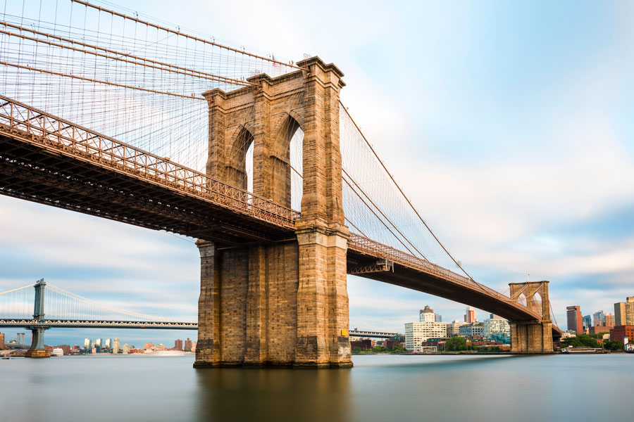
The Brooklyn Bridge crosses the East River between Lower Manhattan and Downtown Brooklyn, connecting the western end of Long Island with the heart of New York City. When it opened on May 24, 1883, it was the world’s longest suspension bridge and the first permanent bridge across the East River. Today, its granite towers, sweeping cables, elevated pedestrian promenade, and views of the Manhattan skyline make it one of the city’s most recognizable landmarks.
The bridge remains an active transportation route as well as a major sightseeing destination. Passenger vehicles cross on the roadway, cyclists use a protected two-way bike lane, and pedestrians can walk above the traffic on the historic promenade. There is no toll to cross the Brooklyn Bridge, whether traveling by passenger vehicle, bicycle, or on foot.
History of the Brooklyn Bridge
The Brooklyn Bridge was conceived by engineer John A. Roebling as a permanent connection between the then-separate cities of New York and Brooklyn. Building such a bridge across the busy East River was an extraordinary engineering challenge during the 19th century, requiring a span large enough to accommodate maritime traffic while creating a dependable transportation connection between the two growing cities.
John Roebling died before construction was completed, and responsibility for the project passed to his son, Washington Roebling. Washington became seriously ill during construction, leaving him unable to regularly visit the site. His wife, Emily Warren Roebling, assumed an important role in communicating between her husband and the engineers and contractors working on the bridge, becoming closely associated with the project’s completion.
The Brooklyn Bridge officially opened on May 24, 1883, with a major public celebration. President Chester A. Arthur and New York Governor Grover Cleveland were among the dignitaries participating in the opening. The bridge immediately became both an important transportation connection and a symbol of American engineering.
At the time, Brooklyn was still an independent city. Brooklyn did not become part of the consolidated City of New York until 1898, meaning the bridge spent its first 15 years physically connecting two separate cities. As development continued on both sides of the East River, the crossing became increasingly important to the movement of people and commerce between Manhattan and Brooklyn.
The bridge’s historical and architectural importance has since received formal recognition. The Brooklyn Bridge was designated a National Historic Landmark in 1964 and a New York City Landmark in 1967, helping preserve one of the most significant surviving structures from the city’s 19th-century transformation.
Design and Engineering
The Brooklyn Bridge combines suspension and cable-stayed engineering principles, with massive stone towers supporting its distinctive network of cables. Its neo-Gothic towers are among the structure’s most recognizable architectural features, rising above the East River with large pointed arches through which the roadway and promenade pass.
The main span measures approximately 1,595.5 feet, while the entire bridge extends about 6,016 feet, or roughly 1.1 miles, from end to end. The structure provides approximately 127 feet of clearance above mean high water, allowing marine traffic to pass beneath the bridge.
One of the bridge’s most unusual features is its elevated promenade. Pedestrians cross above the vehicle roadway rather than directly alongside traffic, creating broad views of the East River, Lower Manhattan, Brooklyn, New York Harbor, and surrounding bridges. Cyclists formerly shared portions of this elevated space but now use a separate protected two-way bicycle lane on the roadway.
Walking Across the Brooklyn Bridge
Walking the Brooklyn Bridge has become one of the most popular free sightseeing experiences in New York City. The full crossing is approximately 1.1 miles from end to end. Many visitors allow about 25 to 45 minutes for a one-way walk, although photography, sightseeing, and heavy pedestrian traffic can make the trip considerably longer.
The elevated promenade passes directly through the bridge’s massive stone towers and provides changing views throughout the crossing. Walking toward Manhattan reveals increasingly prominent views of the Lower Manhattan skyline, while the Brooklyn-bound direction opens toward Brooklyn and the waterfront. The Statue of Liberty and portions of New York Harbor can also be visible from the bridge under suitable conditions.
Early morning is generally one of the quieter times to walk, while the period around sunset can provide particularly dramatic skyline and harbor views. Pleasant weekends, holidays, and peak sightseeing periods tend to bring the largest crowds.
Food, restrooms, and shade are limited on the bridge itself, so visitors planning a leisurely crossing should prepare before entering the promenade. Weather conditions can also feel different above the open East River, particularly when wind, heat, or cold is significant.
Pedestrian and Bicycle Access
Pedestrians can enter the bridge from approaches near City Hall, Centre Street, and Park Row on the Manhattan side. In Brooklyn, common approaches are around Cadman Plaza East and Tillary Street. Construction, maintenance, security activity, or other city work can occasionally alter access routes, so visitors should follow posted signs when approaching the bridge.
The elevated promenade is reserved for pedestrians. Cyclists use the separate protected two-way bicycle lane on the roadway and should follow current New York City bicycle regulations and bridge signage. Separating bicycle and pedestrian traffic has made the historic promenade primarily a walking and sightseeing space.
Getting to the Brooklyn Bridge
The bridge is surrounded by extensive New York City subway service on both sides of the East River. On the Manhattan side, nearby stations include Brooklyn Bridge-City Hall, served by the 4, 5, and 6 trains; Chambers Street, served by the J and Z; and City Hall, served by the R and W.
On the Brooklyn side, nearby subway options include High Street-Brooklyn Bridge on the A and C lines, York Street on the F line, and Clark Street on the 2 and 3 lines. Subway routes and service patterns can change because of construction and scheduled maintenance, particularly during nights and weekends.
The Brooklyn Bridge also carries passenger vehicle traffic between Manhattan and Brooklyn. Crossing the bridge itself is free, but trucks are generally prohibited. Drivers should expect traffic conditions to vary substantially depending on the time of day and conditions elsewhere in the city’s road network.
Brooklyn Bridge Park and DUMBO
The Brooklyn end of the bridge places visitors close to Brooklyn Bridge Park and DUMBO, two of the most popular waterfront destinations in Brooklyn. Brooklyn Bridge Park extends along the East River with piers, lawns, playgrounds, waterfront paths, recreation areas, and extensive views of Manhattan and New York Harbor.
DUMBO sits near the bridge’s Brooklyn approaches and is known for cobblestone streets, converted industrial buildings, waterfront views, restaurants, shops, and frequently photographed streetscapes. The neighborhood’s location between the Brooklyn and Manhattan bridges makes it particularly popular with photographers and visitors exploring the East River waterfront.
Lower Manhattan and Nearby Landmarks
Walking toward Manhattan brings visitors into the Civic Center and Lower Manhattan, where several major New York City destinations are within walking distance or a short subway ride. City Hall Park is immediately near the Manhattan approach, while the Financial District, South Street Seaport, and Pier 17 are nearby.
Farther into Lower Manhattan, visitors can reach One World Observatory and the 9/11 Memorial & Museum. This concentration of attractions makes the Brooklyn Bridge particularly easy to incorporate into a larger walking itinerary connecting Brooklyn’s waterfront with Lower Manhattan.
The Brooklyn Bridge and Long Island
The Brooklyn Bridge also has a direct geographic connection to Long Island. Brooklyn occupies the western end of the island, and the bridge provides one of the best-known crossings between Long Island and Manhattan.
For Long Island residents traveling through Brooklyn or visitors exploring the western end of the island, the bridge offers a free connection into Lower Manhattan while also functioning as a destination in its own right. Its location makes it possible to combine a bridge crossing with Brooklyn Bridge Park, DUMBO, the Civic Center, the Financial District, and other nearby attractions without relying on a car.
Planning a Visit
The Brooklyn Bridge is generally accessible around the clock and there is no admission charge for walking across it. Occasional maintenance, construction, demonstrations, filming, security measures, or emergency activity can affect access and crowd levels.
Visitors should remain within designated pedestrian areas and follow posted directions. Comfortable walking shoes are useful for the roughly 1.1-mile crossing, and anyone planning to walk in both directions should account for more than two miles of walking before adding time spent exploring surrounding neighborhoods.
Because the bridge is exposed to the weather, conditions can change quickly. Sun protection and water can be important during warm weather, while wind and cold can make winter crossings feel considerably colder than surrounding streets. Visitors on a tight schedule should also check current transportation and access conditions before arriving.
Brooklyn Bridge
Key Facts and Details
| Name | Brooklyn Bridge |
| Location | New York City |
| Crosses | East River |
| Connects | Lower Manhattan and Brooklyn |
| Opened | May 24, 1883 |
| Original Engineer | John A. Roebling |
| Construction Leadership | Washington Roebling, with an important communications and project role performed by Emily Warren Roebling |
| Bridge Type | Hybrid cable-stayed and suspension bridge |
| Architecture | Neo-Gothic stone towers with pointed arches |
| Main Span | Approximately 1,595.5 feet |
| Total Length | Approximately 6,016 feet, or about 1.1 miles |
| Clearance | Approximately 127 feet above mean high water |
| Pedestrian Access | Elevated pedestrian promenade above the roadway |
| Bicycle Access | Protected two-way bicycle lane on the roadway |
| Walking Time | Approximately 25 to 45 minutes one way, depending on crowds and sightseeing stops |
| Toll | Free |
| Vehicle Access | Passenger vehicles permitted; trucks generally prohibited |
| National Historic Landmark | Designated in 1964 |
| New York City Landmark | Designated in 1967 |
| Manhattan Area | Civic Center and City Hall area |
| Brooklyn Area | Downtown Brooklyn and DUMBO vicinity |
| Nearby Brooklyn Destinations | Brooklyn Bridge Park and DUMBO |
| Nearby Manhattan Destinations | City Hall Park, South Street Seaport, Pier 17, Financial District, One World Observatory, and the 9/11 Memorial & Museum |
| Best Known For | Historic engineering, granite towers, elevated pedestrian promenade, East River views, and the Manhattan skyline |
The Brooklyn Bridge remains remarkable because it functions simultaneously as transportation infrastructure, a historic engineering achievement, and one of New York City’s most recognizable public spaces. More than a century after connecting the once-independent cities of Brooklyn and New York, pedestrians still cross the East River beneath its cables much as generations of New Yorkers have since 1883. For Long Island, the bridge is also an important part of the island’s western geography, linking Brooklyn with Manhattan while providing one of the most memorable skyline walks in the region.
Are you ready for fall on Long Island? Check out these local seasonal guides:
🍎 Apple Picking | 🍂 Fall Festivals & Farm Activities | 👻 Haunted Houses | 🎃 Pumpkin Picking
