
West Gilgo Beach, New York
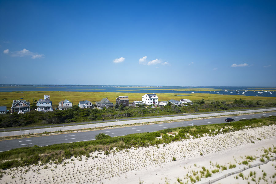
West Gilgo Beach is a small, private barrier-island community along Ocean Parkway in the Town of Babylon, Suffolk County. Just east of the Nassau-Suffolk county line, it sits between the public beach areas of Tobay Beach and Gilgo Beach. Its houses and narrow neighborhood roads occupy a coastal landscape shaped by the Atlantic Ocean to the south and sheltered tidal waters to the north. Unlike the larger beaches along this stretch of Long Island’s South Shore, West Gilgo is a residential enclave rather than a public bathing facility.
The community is notable not simply for its setting but for its remarkable origin: many of its original cottages were moved here from an earlier beach colony called High Hill Beach when the Jones Beach parkway project displaced that settlement. The relocated houses and the cooperative organization established to manage them gave West Gilgo Beach an identity that still distinguishes it from neighboring shoreline destinations.
Location and Barrier-Island Geography
West Gilgo Beach occupies the western end of the Town of Babylon’s barrier beach communities, close to the boundary with Nassau County. Ocean Parkway runs through the narrow coastal corridor, with the open Atlantic and protective dune system to the south. On the landward side, the community faces the back-bay environment near South Oyster Bay, which connects eastward with the larger Great South Bay system. These neighboring bays are related, but they are not interchangeable geographic names.
West Gilgo is generally grouped with the communities of Gilgo Beach, Oak Island, Oak Beach, and Captree Island. The Town of Babylon notes that historical maps used the names Oak Island Beach or Oak Beach Island for portions of the barrier system that are now often collectively called Jones Beach Island. Construction of the parkway changed the shoreline and the way these places appeared on maps, making some historical place names difficult to reconcile with modern road maps. The town’s explanation of barrier-beach place names provides useful context.
The High Hill Beach Community and Its Relocation
The most unusual chapter in West Gilgo Beach history begins to the west at High Hill Beach, a seasonal cottage community that existed near what became Jones Beach State Park. As the state expanded the park and the Ocean Parkway corridor during the late 1930s, High Hill residents faced the loss of their established summer settlement. Rather than abandon their cottages and their community ties, many arranged to move the buildings to a new location just over the Suffolk County line.
According to the Town of Babylon’s barrier beach history, more than 60 of High Hill’s roughly 80 cottages were relocated to West Gilgo Beach. Historical accounts describe houses being transported along the new roadway and by barge through nearby waterways. Moving entire beach houses was a substantial undertaking, but it allowed families to preserve buildings that were already part of their lives while beginning a new chapter on the coast.
The West Gilgo Beach Association was established in 1939 as the community took shape. An account published by the Barrier Beach Civic Association describes how the move was organized around a cooperative arrangement with the Town of Babylon. This history helps explain why West Gilgo has the feel of an established beach colony rather than a conventional subdivision: its layout and social traditions grew out of a community that had already existed elsewhere.
Land Leases and the West Gilgo Beach Association
West Gilgo Beach is associated with a land-lease system found in several Babylon barrier beach communities. Rather than assuming each homeowner owns the underlying parcel outright, the community’s arrangement has historically involved a master lease between the town and the West Gilgo Beach Association, with individual property interests managed through related agreements. The arrangement differs from the ordinary ownership model in many mainland neighborhoods and is a significant part of the community’s history.
A document prepared for a May 2025 Suffolk County Water Authority board meeting refers to the association’s renewed master lease with the Town of Babylon, dated August 14, 1990. The document also describes the association as the operator of a local water system serving approximately 81 customer accounts at that time. These details illustrate the unusual degree to which a small coastal community has historically needed to organize shared services and infrastructure. Lease provisions, utility arrangements, and responsibilities should be confirmed through current official records rather than assumed from older descriptions.
Community Life and Neighborhood Character
West Gilgo Beach is small enough that its streets, cottages, and shared coastal surroundings form a closely connected neighborhood. Many homes retain the scale of traditional beach houses, although properties have been altered, elevated, or improved over time. The community has historically included both seasonal and year-round residents, so its rhythms differ between quiet winter months and the height of the summer season.
Its setting offers an unusual combination of privacy and exposure to the natural elements. Residents are close to ocean dunes, tidal wetlands, salt air, and open water, yet the same landscape can be vulnerable to strong winds, flooding, and erosion. Shared infrastructure, storm preparation, and care for common spaces are therefore practical concerns as well as matters of neighborhood identity.
The Town of Babylon identifies West Gilgo and its neighboring barrier communities as part of the Babylon postal and school districts, with the 11702 ZIP code and fire protection provided through the Babylon Fire Department. Those municipal connections are useful reminders that, despite the isolated beach setting, West Gilgo remains part of the broader Babylon community.
The Ocean, Bays, Dunes, and Wildlife
The narrow strip of land surrounding West Gilgo is a working barrier-island ecosystem. Ocean waves and coastal storms continually shape the beach, while dunes and beach grasses help stabilize sand farther inland. To the north, tidal channels and shallow bays support fish, shellfish, marsh plants, and a wide variety of birds. The transition from surf to dunes to tidal wetlands occurs over a remarkably short distance, creating a landscape that is both beautiful and environmentally sensitive.
For those interested in birdwatching, the broader South Shore coast provides habitat for shorebirds, herons, egrets, and other species that depend on beaches and wetlands. Nesting areas and protected dunes should be viewed only from permitted public locations. Coastal photography is also popular along the wider Ocean Parkway corridor, especially when the light falls across the dunes and back-bay marshes, but private property and roadway safety restrictions remain important.
The New York State Department of State identifies nearby South Oyster Bay as a significant coastal fish and wildlife habitat. Its habitat description explains the ecological importance of this shallow estuary and its surrounding marshes. Protecting vegetation, limiting disturbance to wildlife, and keeping litter out of tidal waters are important throughout this stretch of the South Shore.
Recreation Along the Ocean Parkway Corridor
West Gilgo Beach itself is not a public recreation center, but it lies within reach of several well-known coastal destinations. Gilgo Beach to the east is a Town of Babylon ocean beach with seasonal swimming and visitor amenities. Tobay Beach to the west is managed by the Town of Oyster Bay, while Jones Beach State Park provides a larger state-park experience farther west. Each has its own parking, permit, lifeguard, and seasonal rules.
Nearby activities include swimming and surfing at beaches where those activities are permitted, fishing in designated shoreline areas, and boating on the bays and connecting channels. Boaters should use authorized marinas and launch sites rather than private community docks. Captree State Park farther east is a useful destination for fishing excursions and access to the waters around Fire Island Inlet.
Cyclists can explore portions of the Ocean Parkway Coastal Greenway, which provides a dedicated recreation route along the barrier-island corridor. The greenway and established public beach facilities are more suitable for visitors than entering private neighborhood roads or attempting to stop along the parkway shoulder. Beachgoers should also recognize that access to the ocean is not necessarily public simply because the shoreline can be seen from the road.
Private Access and Visiting West Gilgo Beach
West Gilgo Beach is a gated, primarily residential community. It does not function as a conventional public beach, and visitors should not expect an open parking field, public bathhouse, concession area, or unrestricted entrance through the neighborhood. Residents and authorized guests may have access to private facilities, but those privileges should not be confused with the admission rules at nearby municipal beaches.
For a day at the ocean, the clearest alternatives are Gilgo Beach, Tobay Beach, and Jones Beach State Park. The Town of Babylon states that Gilgo Beach is open to residents and non-residents during its operating season, with different admission arrangements depending on permits and the day of the week. Visitors can review current Gilgo Beach information before leaving home. Access policies at Tobay and Jones Beach are administered separately.
The community is reached from Ocean Parkway, but travelers should follow posted entrance restrictions and never park on the roadway shoulder or block private drives. There is no regular railroad station within West Gilgo Beach, and practical visits to the public beaches along this part of the coast usually involve a car or bicycle. The best way for a nonresident to appreciate West Gilgo itself is often as part of a drive through the surrounding barrier-island landscape.
Storms, Coastal Change, and Resilience
Barrier islands are constantly reshaped by tides, waves, and storms. The narrow landmass near West Gilgo is exposed to coastal flooding, wind damage, and changes in beach elevation. Superstorm Sandy in 2012 demonstrated how quickly powerful weather systems can affect homes, roads, utilities, and dune systems along Long Island’s southern coast. The challenges of maintaining access and protecting property are especially pronounced in small waterfront settlements.
Protective dunes, elevated structures, careful drainage, and sound emergency planning all matter in a community with limited access routes. Coastal protection is not only a question of maintaining beach width; it also involves protecting tidal wetlands and keeping the natural systems that absorb wave energy functioning. Residents and visitors alike should heed posted dune closures, weather alerts, and official guidance during coastal storms.
West Gilgo Beach and Its Neighboring Communities
West Gilgo Beach shares its broader setting with Gilgo Beach, a separate community and public beach area immediately to the east. Farther along the parkway are Oak Island and Oak Beach, which also have distinctive residential histories, and Captree State Park, known for boating and fishing. To the west, Tobay Beach and Jones Beach State Park provide major recreation facilities with a very different scale and public purpose.
Together these places illustrate the variety found along a single barrier-island corridor: private cottage colonies, town beaches, state parks, marinas, and protected natural areas exist within a short drive of one another. West Gilgo Beach is an important part of that story because its history preserves the memory of High Hill Beach, a community physically moved to make way for one of Long Island’s most consequential public-park projects.
West Gilgo Beach, New York
Key Facts & Details
| Category | Details |
|---|---|
| Location | Town of Babylon, Suffolk County, near the Nassau County line |
| Community Type | Private, gated barrier-island residential community |
| Historic Origin | Established in 1939 following the relocation of High Hill Beach residents and cottages |
| Historic Relocation | More than 60 of roughly 80 High Hill cottages moved to West Gilgo Beach, according to the Town of Babylon |
| Community Organization | West Gilgo Beach Association, established circa 1939 |
| Land Arrangement | Historically operated through a town master lease and association-managed property arrangements |
| Road Access | Ocean Parkway; private community entrance |
| Waterfront Setting | Atlantic Ocean to the south; South Oyster Bay and connecting South Shore back-bay waters to the north |
| Public Access | Private residential area; no general public beach admission or visitor parking within the community |
| Nearby Public Beaches | Gilgo Beach, Tobay Beach, and Jones Beach State Park |
| Other Nearby Destinations | Oak Beach, Oak Island, and Captree State Park |
| ZIP Code | 11702 (Babylon postal district) |
| School and Fire District | Babylon School District; Babylon Fire Department |
| Known For | Relocated historic cottages, private coastal living, and a distinctive beach-colony heritage |
West Gilgo Beach remains one of the most unusual neighborhoods along Long Island’s South Shore, not because it offers a major public attraction, but because it preserves a living connection to the vanished High Hill Beach community. The cottages relocated during the 1930s, the cooperative land arrangements, and the shared responsibility of living on a narrow barrier island all contribute to its character. For visitors, nearby Gilgo Beach and Tobay Beach provide more practical public recreation, while West Gilgo itself tells a distinctive story of coastal history, adaptation, and community continuity.
Are you ready for fall on Long Island? Check out these local seasonal guides:
🍎 Apple Picking | 🍂 Fall Festivals | 👻 Haunted Houses | 🦃 Thanksgiving Dinner & Activities