
Oak Beach, New York
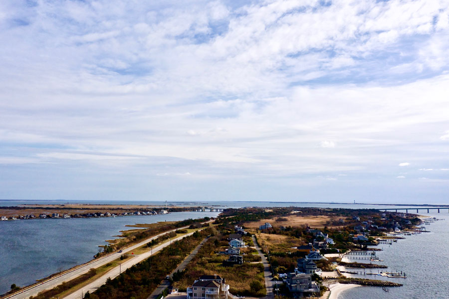
Oak Beach is a small waterfront community on the barrier islands of Long Island, within the Town of Babylon in Suffolk County, New York. Located along Ocean Parkway near the western side of Fire Island Inlet, the neighborhood is surrounded by tidal waterways, salt marshes, and the coastal scenery of the South Shore. Its low-rise homes, private docks, and historic connections to fishing and boating give Oak Beach a character quite different from the region’s larger, heavily visited ocean beaches.
Although the name suggests a conventional beach resort, Oak Beach is primarily a residential enclave rather than a destination with a large public swimming beach or commercial boardwalk. The nearby Great South Bay, Fire Island Inlet, and Atlantic Ocean have shaped its history and daily life. Visitors can enjoy public recreation in the surrounding area, but should distinguish public parks and shoreline access from the community’s private roads, homes, and waterfront properties.
Where Oak Beach Is Located
Oak Beach lies toward the eastern end of the barrier-island corridor traversed by Ocean Parkway, west of Captree State Park and near the approaches to Fire Island Inlet. Across the waterways to the north are the mainland communities of the Town of Babylon; farther west along the parkway are Gilgo Beach and West Gilgo Beach. This position gives the neighborhood a distinctive mix of bayfront scenery, tidal wetlands, and views toward the inlet.
The nearby community of Oak Island should not be confused with Oak Beach. Oak Island is a separate, boat-access residential settlement in the bay, while Oak Beach is reached by road. Historic maps also used names such as Oak Beach Island and Oak Island Beach for portions of the larger barrier-island landscape, which can make older accounts and modern place names difficult to reconcile. The Town of Babylon’s explanation of its barrier beach communities provides useful context for these distinctions.
From Life-Saving Station to Seaside Community
Oak Beach has a longer and more varied history than its quiet streets might suggest. Long before today’s roadway connections, this stretch of coast was valued for shellfishing, fishing, waterfowl hunting, and access to the bay. Travel across the water was central to life here, and the changing shoals and inlets made navigation hazardous for vessels moving along the Atlantic coast.
According to the Town of Babylon’s barrier beach history, U.S. Life-Saving Service stations were established at Oak Beach and Gilgo Beach in 1872. Their crews watched the dangerous shoreline and responded to ships in distress before modern rescue systems existed. The U.S. Coast Guard assumed the Life-Saving Service’s responsibilities in 1915, and the Oak Beach station remained active through World War II. This maritime rescue heritage is an important part of the community’s identity.
The former life-saving and Coast Guard station also has a continuing community role. The Barrier Beach Civic Association describes the Oak Beach Community Center as a historic station building used for local gatherings and historical interpretation. It is a reminder that Oak Beach was once an isolated outpost where a life-saving crew was among the most important year-round presences.
Ferries, Summer Cottages, and the Oak Beach Inn
Before bridges and parkways made barrier-island travel routine, ferries brought summer visitors from the mainland to the beaches and gathering places around Great South Bay. Fishing camps, modest cottages, and seasonal recreation gradually became part of the landscape. The Town of Babylon identifies Sidney Van Nostrand’s Pavilion at Oak Beach as one of the early seaside attractions serving visitors from the region and Long Island beyond.
In 1935, the Oak Beach Inn opened as a successor to the earlier pavilion, becoming a recognizable social landmark along the coast. Its history illustrates a different era of Oak Beach, when the area drew visitors for waterfront entertainment as well as for the scenery. Today, the community is more strongly identified with its homes and maritime setting than with the former resort establishments.
The construction and expansion of Ocean Parkway during the 20th century transformed access to this part of the South Shore. A journey that once depended on boats could increasingly be made by automobile. The opening of the Robert Moses Causeway in 1951 further improved regional access, helping the wider barrier-island communities evolve from predominantly seasonal retreats toward more year-round living.
A Distinctive Residential and Leasehold Community
Many Oak Beach homes stand on land owned by the Town of Babylon and occupied under long-term lease arrangements. That structure differs from the fee-simple ownership common in most suburban neighborhoods, and it has influenced local governance, land use, and the preservation of the barrier beaches. Individual arrangements can vary, so anyone researching a specific property should review its current lease and applicable town requirements rather than assume all parcels are identical.
Oak Beach is part of a wider group of Town of Babylon barrier beach settlements, including Oak Island, Gilgo Beach, West Gilgo Beach, and parts of Captree Island. Community organizations have historically addressed shared concerns such as erosion, emergency services, lease terms, and the upkeep of local facilities. The Barrier Beach Civic Association’s historical account describes decades of resident involvement in these issues.
The built environment reflects the demands of coastal living. Raised houses, stairs, decks, docks, and bulkheads appear throughout the neighborhood, while narrow residential roads and nearby marshes reinforce its intimate scale. Some properties are occupied year-round and others seasonally, but the neighborhood should be treated as a place where people live, not as an open-access tourist attraction.
Great South Bay, Fire Island Inlet, and the Coastal Landscape
The landscape around Oak Beach is shaped by the meeting of the Great South Bay, connecting channels, and the powerful tidal exchange at Fire Island Inlet. The sheltered bay supports small-boat activity and estuarine wildlife, while the inlet provides a passage between protected inland waters and the Atlantic Ocean. These waterways are continually influenced by tides, storms, sediment movement, and changing shoreline conditions.
From different vantage points, visitors may see shallow tidal flats, salt marshes, low dunes, open water, and distant boats heading toward the inlet. This is not a static landscape. Channels can shift, shoreline edges may erode or accrete, and navigational conditions demand attention from boaters. The same processes that create beautiful coastal scenery also make infrastructure and property protection ongoing challenges.
Oak Beach is also associated with the western approaches to Fire Island Inlet rather than a broad, uninterrupted Atlantic swimming beach within its residential blocks. For a conventional day on the sand, visitors are generally better served by established, publicly managed ocean beaches elsewhere along the barrier island.
Boating, Fishing, and Waterfront Recreation
Boating is central to the identity of Oak Beach. Private docks and small craft reflect the neighborhood’s close relationship with the bay, and nearby waters connect to channels used by recreational anglers, sailing vessels, and other boaters. Those interested in getting out on the water without private access can explore the wider region’s boating and boat-rental options, including facilities and excursions operating from established marinas.
Fishing has equally deep roots here. The waters near Fire Island Inlet attract anglers seeking species that move between ocean and bay habitats, although fishing locations, regulations, tides, and safe access must all be considered. Captree State Park is a practical nearby destination for people seeking charter or party-boat fishing opportunities and publicly accessible waterfront facilities.
For those who prefer to remain on land, the Ocean Parkway corridor offers a different kind of coastal outing. Designated public areas along the route provide opportunities to appreciate the scenery, and the region’s shared-use path is popular for walking and cycling. Visitors should use official trail entrances and parking areas rather than stopping along the parkway shoulder or entering private residential streets.
Wildlife, Birdwatching, and Coastal Habitats
The marshes and shallow waters around Oak Beach belong to the larger South Shore estuary, an environment important to fish, shellfish, shorebirds, and migrating waterfowl. Ospreys, herons, egrets, gulls, and other coastal birds may be seen in suitable seasons. For visitors interested in birdwatching on Long Island, the broader barrier beach landscape offers rewarding opportunities, especially where public access and habitat protections are clearly marked.
Salt-marsh plants help stabilize the edges of tidal waterways and provide habitat for juvenile marine life. Dunes and beach vegetation also play a protective role, reducing windblown sand movement and helping the shoreline respond to storms. Even where a path or open stretch of sand appears inviting, it may be part of a sensitive habitat or a privately controlled area.
Coastal photography is another way to appreciate the area’s distinctive atmosphere. Morning and late-afternoon light can bring out the textures of the marshes, the silhouettes of docks, and the broad horizon over the bay. Publicly accessible viewpoints and established recreation areas are preferable to entering residential property or approaching wildlife too closely.
Storms, Flooding, and Shoreline Protection
Like other low-lying communities on Long Island’s South Shore, Oak Beach is exposed to coastal flooding, high winds, erosion, and changing tides. Superstorm Sandy in 2012 underscored the vulnerability of the barrier beaches and helped drive conversations about rebuilding, infrastructure, emergency planning, and shoreline resilience.
The New York State West Gilgo to Captree Community Reconstruction Plan examined the challenges faced by the connected barrier beach communities after Sandy, including the implications of living on leased coastal land. The plan also documented how residents have become increasingly year-round in places that were historically summer retreats.
For homeowners, preparedness may involve elevated structures, flood insurance, safe evacuation planning, and maintenance suited to saltwater conditions. For visitors, it means checking weather and road conditions before traveling to the barrier island, especially when coastal storm warnings or unusually high tides are in effect.
Public Parks and Nearby Places to Explore
Oak Beach itself has limited conventional visitor services, but it sits within reach of several well-known destinations. Captree State Park to the east offers a more established public recreation setting with fishing and boating connections near Fire Island Inlet. Farther west, Gilgo Beach and Jones Beach State Park provide alternatives for visitors primarily interested in the ocean shoreline. Public access, fees, seasonal hours, and parking arrangements differ among these sites.
Oak Beach Park is also associated with the waterfront area near the community, but it should not be confused with an unrestricted ocean beach or a county-run bathing facility. Before making plans for a specific park, pier, or shoreline access point, check the current managing agency’s rules and confirm which amenities are actually open. The names of nearby parks and older facilities are sometimes used loosely in online descriptions.
Visitors interested in the character of the wider barrier-island corridor may also read about Oak Island, West Gilgo Beach, and Gilgo Beach. Each developed under different access conditions, but all share connections to the bay, the beach, and the history of seasonal waterfront settlement.
Getting to Oak Beach and Planning a Visit
Most people reach Oak Beach by automobile using Ocean Parkway and the connecting causeway network. The area is not served like a walkable downtown with frequent shops, restaurants, or a nearby rail platform. Travelers using the Long Island Rail Road would generally need an additional vehicle connection to reach this stretch of the barrier island.
Because residential streets, docks, and beach access points may be private or restricted, it is best to choose a specific public destination before setting out. Verify legal parking, operating hours, and any permits for fishing or other activities. During summer weekends, parkway traffic and parking demand can be substantial; in colder months, exposed winds and changing weather can make the shoreline feel much more remote.
If the goal is ocean swimming, look for designated guarded beaches rather than assuming access from the Oak Beach neighborhood. For surfing, the wider South Shore has established beach destinations where local regulations and conditions can be checked in advance. Those seeking a quiet coastal drive or a look at the bay may find the surrounding public parks more practical than the residential streets themselves.
Oak Beach, New York
Key Facts & Details
| Category | Details |
|---|---|
| Location | Barrier beach community in the Town of Babylon, Suffolk County, New York |
| Regional Setting | Long Island’s South Shore, near Fire Island Inlet and the Great South Bay |
| Primary Road Access | Ocean Parkway |
| Community Character | Small residential waterfront neighborhood with year-round and seasonal occupancy |
| Land Tenure | Many homes are privately owned on land held under long-term Town of Babylon leases |
| Historic Landmark | Oak Beach U.S. Life-Saving Service station; life-saving presence dates to 1872 |
| Historic Resort Site | Oak Beach Pavilion and the Oak Beach Inn, which opened in 1935 |
| Waterways | Great South Bay, Fire Island Inlet, and access toward the Atlantic Ocean |
| Nearby Communities | Oak Island, Gilgo Beach, West Gilgo Beach and Captree Island |
| Nearby Public Recreation | Captree State Park, Gilgo Beach and Jones Beach State Park |
| Recreation | Boating, fishing, birdwatching and coastal photography in appropriate public-access areas |
| ZIP Code | 11702 (Babylon mailing area) |
| Visitor Considerations | Primarily residential; confirm public access, parking and seasonal rules before visiting |
Oak Beach remains one of the more distinctive communities on Long Island: a place where historic life-saving traditions, early resort history, town leaseholds, and everyday waterfront living intersect. Its appeal is found less in commercial attractions than in the protected waterways, marshes, and maritime heritage that surround it. With public destinations such as Captree State Park and Gilgo Beach nearby, visitors can explore the region’s coastal scenery while respecting the privacy and environmental sensitivity of Oak Beach itself.
Are you ready for fall on Long Island? Check out these local seasonal guides:
🍎 Apple Picking | 🍂 Fall Festivals | 👻 Haunted Houses | 🦃 Thanksgiving Dinner & Activities