
Riverside, New York
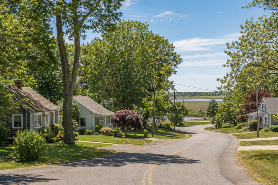
Riverside is a hamlet and census-designated place in the Town of Southampton, Suffolk County, on the East End of Long Island. The community occupies the southern bank of the Peconic River immediately across the water from downtown Riverhead.
Riverside had a population of 2,882 at the 2020 United States Census. The census-designated place covers approximately 2.75 square miles, including about 2.65 square miles of land and 0.10 square miles of water.
Although Riverside is governed by the Town of Southampton, its Riverhead mailing address, proximity to downtown Riverhead, shared school district, nearby train station, and dependence on Riverhead businesses and institutions give the hamlet a particularly close relationship with the neighboring town. The Peconic River forms both a natural feature and a municipal boundary between the two communities.
Community Overview
Riverside is an unincorporated hamlet governed by the Town of Southampton. It does not have an independent village government, although the United States Census Bureau defines Riverside as a census-designated place for statistical purposes.
The community includes residential neighborhoods, commercial properties, public institutions, undeveloped parcels, wooded areas, wetlands, and land along the Peconic River. Development is concentrated near Flanders Road, Riverleigh Avenue, Peconic Avenue, Center Drive, Nugent Drive, and the network of smaller streets extending south and east from the river.
Riverside does not currently have a traditional downtown comparable to the business district directly across the river in Riverhead. Long-term planning efforts have sought to establish a more recognizable, walkable hamlet center with housing, businesses, public spaces, pedestrian connections, and improved access to the waterfront.
Location Along the Peconic River
Riverside is situated at an important geographic transition between central Suffolk County and the East End. The hamlet lies south of Riverhead, west of Flanders, north of Northampton, and near the northern edge of the Long Island Central Pine Barrens.
The Peconic River follows Riverside’s northern boundary before continuing east toward the Peconic estuary and bay system. Bridges across the river provide direct access to downtown Riverhead, placing Riverside residents close to stores, restaurants, government offices, cultural destinations, public transportation, and medical services.
Riverside is generally considered part of the western gateway to the East End. Major roads passing through the hamlet carry travelers toward the North Fork, South Fork, Hamptons, Riverhead shopping districts, Suffolk County offices, and communities surrounding the Peconic bays.
Riverside and Downtown Riverhead
Few neighboring Long Island communities are as closely connected as Riverside and Riverhead. Riverside is located in the Town of Southampton, while downtown Riverhead is governed by the Town of Riverhead. The Peconic River and the municipal boundary separate them, but bridges, roads, institutions, and everyday travel connect the two areas.
Peconic Avenue crosses the river and enters downtown Riverhead near East Main Street and the riverfront business district. This short connection places portions of Riverside within walking distance of downtown restaurants, shops, public events, cultural attractions, and the Riverhead Long Island Rail Road station.
Riverside properties normally use the Riverhead postal designation and ZIP code 11901. A postal address does not determine municipal jurisdiction, however, and Riverside properties remain within the Town of Southampton for town-government purposes.
The relationship between the two communities has also affected redevelopment and infrastructure planning. Projects involving traffic, wastewater, the Peconic River, environmental protection, or development near the municipal boundary can have consequences on both sides of the river.
Riverside Maritime Trail Park
Riverside Maritime Trail Park provides public access to the Peconic River along the hamlet’s northern shoreline. The park was developed as a central component of the Riverside Revitalization Action Plan and the Riverside Brownfield Opportunity Area planning process.
The waterfront park officially opened in May 2024. Its development transformed previously underused riverfront land into a public space designed for walking, passive recreation, environmental education, wildlife observation, and community use.
Features include an accessible walking trail, seating areas, views across the Peconic River, native landscaping, shoreline improvements, and connections with the natural wetland environment. The project also included efforts to restore shoreline habitat and improve the public’s relationship with the river.
Long-range plans envision the maritime trail as part of a larger riverfront network. Planning documents have described the possibility of an approximately 1.6-mile trail extending east from the Peconic Avenue area through county, town, and privately owned waterfront properties, although completion depends on future planning, property arrangements, funding, and environmental approvals.
Peconic River and Wetlands
The Peconic River is one of Riverside’s defining natural features. The river begins farther west in central Suffolk County and flows east through freshwater and tidal environments before reaching the Peconic estuary.
Wetlands along the river provide wildlife habitat, help filter runoff, store floodwater, and support the environmental health of the larger watershed. Birds, fish, turtles, amphibians, and other wildlife use the river and its surrounding marshes, woodlands, and shallow-water habitats.
Because Riverside is located beside the river and contains areas with a relatively high water table, wastewater treatment, stormwater runoff, flooding, shoreline development, and groundwater protection are important local concerns. These environmental conditions have also influenced the scale and type of development that can occur under conventional septic systems.
Development near wetlands, flood-prone land, and the river may require review by town, county, state, or federal agencies. Property owners should verify applicable wetlands regulations, flood-zone requirements, clearing restrictions, permits, and environmental conditions before beginning construction or altering a property.
Riverside Revitalization Action Plan
Riverside has been the subject of extensive revitalization planning intended to improve housing, infrastructure, economic opportunity, public spaces, pedestrian access, environmental conditions, and the appearance of the principal commercial corridors.
The Town of Southampton adopted the Riverside Revitalization Action Plan and related land-use measures following years of public discussion and earlier studies involving Riverside, Flanders, and Northampton. The plan identified redevelopment opportunities around Flanders Road, Peconic Avenue, Riverleigh Avenue, and the riverfront.
The Riverside Overlay District, adopted in 2015 with form-based development regulations, covers approximately 468 acres. Its planning framework encourages a more compact and pedestrian-oriented mixture of residential, commercial, civic, and recreational uses rather than disconnected development spread across individual parcels.
The plan’s goals include establishing a recognizable hamlet center, improving the streetscape, creating housing options, supporting local businesses, cleaning up underused or environmentally challenged properties, increasing public access to the Peconic River, and strengthening the connection with downtown Riverhead.
Actual redevelopment occurs gradually and depends on private investment, infrastructure, market conditions, environmental review, public funding, and development approvals. Some elements, including Riverside Maritime Trail Park, have been completed, while other parts remain long-term initiatives.
Riverside Sewer District
Wastewater infrastructure is considered one of the most important components of Riverside’s revitalization. Conventional septic systems can limit development density and contribute nitrogen to groundwater and nearby surface waters, particularly in areas close to the Peconic River and with a high water table.
The Southampton Town Board created the Riverside Sewer District in 2024. The planned system, also described as the Riverside Water Recovery Facility, is intended to serve properties within an initial district area and support both water-quality protection and carefully planned redevelopment.
Plans call for a wastewater treatment facility on town-owned land south of Flanders Road. The system is expected to use advanced treatment to reduce nitrogen and other pollutants before treated water is returned to the groundwater system through an approved disposal process.
As of 2026, design work was continuing on a project estimated at approximately $44 million. Town consultants said the system could become operational in late 2029 or early 2030, although major construction schedules, costs, funding sources, connection arrangements, and completion dates can change.
Current planning has included a low-pressure collection system with grinder pumps for certain connected properties. The town has indicated that existing residential properties within the first phase would receive town-funded connections, including abandonment of existing septic systems, while commercial connection responsibilities may differ.
The project has received public funding commitments, including federal infrastructure funding, but continued engineering, construction, easements, environmental compliance, and administrative work will be required before service begins. Property owners should consult the Town of Southampton for the latest district map, costs, schedules, and connection policies.
Flanders Road and the Riverside Roundabout
Flanders Road, designated New York State Route 24, is Riverside’s principal east-west roadway. It travels from the Riverside roundabout through Flanders toward Hampton Bays and provides connections with roads leading to other South Fork communities.
The Riverside roundabout is one of the hamlet’s most prominent transportation features. The modern oval-shaped, two-lane roundabout replaced an older traffic circle and was completed in 2018 to improve traffic flow and safety at a complicated multi-road intersection.
The roundabout connects Flanders Road, Peconic Avenue, Riverleigh Avenue, County Road 63, Nugent Drive, Center Drive, and related approaches. These routes distribute traffic toward downtown Riverhead, the county-government complex, the South Fork, the East End, and communities west of Riverside.
Because several important roads converge in a relatively small area, the roundabout carries substantial commuter, commercial, government, and seasonal traffic. Drivers should follow lane markings, directional signs, pedestrian crossings, and yield requirements carefully when approaching or circulating through the intersection.
Other Major Roads
Peconic Avenue provides one of Riverside’s most direct connections with downtown Riverhead. The road crosses the Peconic River and reaches the riverfront and East Main Street area within a short distance.
Riverleigh Avenue, also designated Suffolk County Road 104, runs south from the roundabout toward Northampton and areas near the Long Island Central Pine Barrens. County Road 63 provides another connection between the Riverhead area and communities farther south.
Nugent Drive and Center Drive serve the Suffolk County government and court complex west of the hamlet center. Drivers can continue west toward County Road 51 and connect with roads leading to the eastern end of the Long Island Expressway.
Seasonal travel toward the Hamptons, North Fork, beaches, wineries, farms, shopping destinations, and other East End attractions can increase traffic throughout the Riverhead and Riverside area. Congestion is particularly likely during summer weekends, holidays, court sessions, and peak commuting periods.
Suffolk County Government and Court Complex
Riverside contains a major concentration of Suffolk County government, court, public-safety, and correctional facilities. Although many of these institutions use Riverhead postal addresses, the complex around Center Drive is located south of the Peconic River within the Town of Southampton.
The Suffolk County Court Complex includes facilities used by the County Court, Supreme Court, Family Court, Surrogate’s Court, and other parts of the state court system. Visitors should verify the exact building, address, courtroom, parking area, security requirements, and arrival time before traveling.
The Arthur M. Cromarty Criminal Court Complex is located at 210 Center Drive. Court visitors are generally required to pass through security screening, and restrictions may apply to weapons, recording devices, photography, food, and other items.
The Suffolk County Sheriff’s Office operates the Riverhead Correctional Facility at 100 Center Drive South. The county complex also contains administrative offices and other government services that bring employees, attorneys, jurors, defendants, families, and members of the public into Riverside throughout the week.
Public Transportation
Riverside does not have its own Long Island Rail Road station. The nearest station is Riverhead, located just north of the Peconic River on the Ronkonkoma Branch’s eastern service corridor.
Riverhead station provides rail service toward communities including Manorville, Medford, Ronkonkoma, and Jamaica, with connections available for travel to other Long Island destinations and New York City. Service east of Ronkonkoma is less frequent than service on many western portions of the railroad, so travelers should check current schedules.
Suffolk County Transit serves the Riverside and Riverhead area. Route 92 travels through the county-center and Flanders Road corridor, connecting Riverside with Riverhead, Flanders, Hampton Bays, Southampton, Bridgehampton, Sag Harbor, East Hampton, North Fork communities, and Orient Point.
Other bus connections are available in Riverhead. Routes, fares, stops, transfer arrangements, and schedules can change, and many parts of Riverside remain easiest to reach by automobile.
Schools and Educational Services
Public-school students in Riverside are generally served by the Riverhead Central School District. The district draws students from portions of the towns of Riverhead, Southampton, and Brookhaven, demonstrating how school-district boundaries can cross municipal lines.
The district operates Riverhead High School, Riverhead Middle School, Pulaski Street Intermediate School, and several elementary schools. Individual school assignments depend on grade level, district policy, enrollment, and the student’s home address.
Town boundaries, postal addresses, census-designated place boundaries, school districts, fire districts, ambulance districts, and voting districts serve different purposes and may not follow the same lines. Families should confirm the school district and assigned schools directly before purchasing or renting a home.
Additional educational resources, libraries, vocational programs, private schools, and higher-education opportunities are available in Riverhead and throughout eastern Suffolk County.
Fire Protection and Emergency Services
Fire-protection arrangements in Riverside involve the Riverhead Fire District and Riverhead Fire Department service area. Emergency-service boundaries do not necessarily match the Riverside census-designated place or Town of Southampton boundary, so property owners should verify the responsible district for a specific address.
Ambulance service in the area is associated with the Flanders-Northampton Volunteer Ambulance District. Police services in areas under town jurisdiction are provided by the Town of Southampton Police Department.
The New York State Police maintains a facility on Riverleigh Avenue, and the nearby Suffolk County court, sheriff, and correctional facilities contribute to a substantial public-safety presence in the community.
Shopping, Dining, and Everyday Services
Riverside contains small businesses, service providers, convenience-oriented commercial properties, and government-related activity, but many residents rely on nearby Riverhead for everyday needs.
Downtown Riverhead offers restaurants, cafés, entertainment, government services, cultural institutions, and riverfront events. Larger shopping centers, supermarkets, national retailers, and professional services are located along Route 58 and other commercial corridors north and west of downtown.
Peconic Bay Medical Center in Riverhead is the nearest major hospital. Additional medical offices, pharmacies, banking services, automotive businesses, and everyday commercial services are available throughout the surrounding Riverhead area.
Riverside’s location also provides convenient driving access to Flanders, Northampton, Hampton Bays, the North Fork, the South Fork, parks, golf courses, farms, vineyards, museums, and other East End destinations.
Housing and Residential Character
Housing in Riverside consists primarily of detached single-family residences, although the community also includes apartments, multifamily properties, accessory living arrangements, and housing associated with planned or proposed redevelopment.
Residential conditions vary by location. Some homes are situated on established neighborhood streets near Flanders Road and the river, while others occupy wooded parcels farther from the hamlet’s principal roads.
Properties near the Peconic River, wetlands, or low-lying land may be affected by flood-zone requirements, groundwater conditions, wetlands regulations, stormwater concerns, and specialized insurance considerations. Buyers and renters should investigate the exact property rather than relying solely on the Riverside mailing address or community name.
Revitalization plans call for additional housing within a more compact, walkable hamlet center. The type, number, timing, and affordability of future units will depend on approved development applications, wastewater capacity, infrastructure, market conditions, and applicable town requirements.
Environmental and Development Considerations
Riverside’s location beside the Peconic River and near the Long Island Central Pine Barrens makes environmental planning particularly important. Groundwater, wetlands, habitat, wastewater, stormwater runoff, and development density are closely connected.
Portions of the community have historically contained vacant, underused, or environmentally constrained properties. Brownfield planning has sought to identify opportunities for cleanup, reuse, public improvements, and development compatible with environmental protections.
The planned sewer system is intended to reduce reliance on individual septic systems within the district and provide advanced wastewater treatment. It is also expected to make certain forms of mixed-use development possible where conventional onsite systems would not provide sufficient capacity.
Property owners and developers may need approvals involving zoning, clearing, wetlands, sewage disposal, traffic, drainage, parking, building design, and environmental review. Requirements vary substantially by parcel and project.
A Community in Transition
Riverside’s identity is shaped by several contrasting roles. It is a residential hamlet, a gateway to the East End, a riverfront community, a government and court center, and the focus of one of the Town of Southampton’s most ambitious long-term revitalization programs.
The opening of Riverside Maritime Trail Park created a new public connection to the Peconic River. Planned wastewater infrastructure could support additional environmental improvements and redevelopment, although completion of the system remains several years away.
Riverside’s future development will depend on balancing economic opportunity, housing needs, transportation, public investment, environmental protection, and the interests of existing residents. Its unusually close relationship with Riverhead will remain important because activity on either side of the river can affect the other community.
Riverside, New York
Key Facts & Details
| Feature | Details |
|---|---|
| Community | Riverside, New York |
| Community Type | Hamlet and census-designated place |
| Town | Town of Southampton |
| County | Suffolk County |
| Island | Long Island |
| Region | East End |
| Population | 2,882 at the 2020 United States Census |
| Total Area | Approximately 2.75 square miles |
| Land Area | Approximately 2.65 square miles |
| Water Area | Approximately 0.10 square miles |
| ZIP Code | 11901, generally using a Riverhead mailing address |
| Area Codes | 631 and 934 |
| FIPS Code | 36-62066 |
| Northern Boundary | Peconic River and the Town of Riverhead boundary |
| Principal Road | Flanders Road, New York State Route 24 |
| Other Major Roads | Peconic Avenue, Riverleigh Avenue, Nugent Drive, Center Drive, County Road 63, and County Road 51 |
| Major Intersection | Riverside roundabout |
| Waterfront Park | Riverside Maritime Trail Park |
| Planning Area | Riverside Overlay District and Riverside Revitalization Action Plan area |
| Wastewater Project | Riverside Sewer District and planned Riverside Water Recovery Facility |
| School District | Riverhead Central School District; verify by property address |
| Fire Protection | Riverhead Fire District and Riverhead Fire Department service area; verify by address |
| Ambulance Service | Flanders-Northampton Volunteer Ambulance District |
| Police Services | Town of Southampton Police Department; New York State Police also maintains a Riverside facility |
| Nearest LIRR Station | Riverhead station on the Long Island Rail Road |
| Public Bus Service | Suffolk County Transit, including Route 92 through the county-center and Flanders Road corridor |
| Major Institutions | Suffolk County Court Complex, county offices, and Riverhead Correctional Facility |
| Known For | Peconic River waterfront, Riverside Maritime Trail Park, county courts and government facilities, the Riverside roundabout, and long-term revitalization planning |
Riverside occupies a distinctive position at the boundary between the towns of Southampton and Riverhead. Its Peconic River waterfront, direct connection with downtown Riverhead, government and court complex, major road network, new maritime park, and continuing infrastructure projects make it both an established residential community and an important focus of future development on the East End.
Are you ready for fall on Long Island? Check out these local seasonal guides:
🍎 Apple Picking 🍓 Strawberry Picking 🎃 Pumpkin Picking 👻 Haunted Houses 🍂 Farm Festivals
