
Middle Island, New York
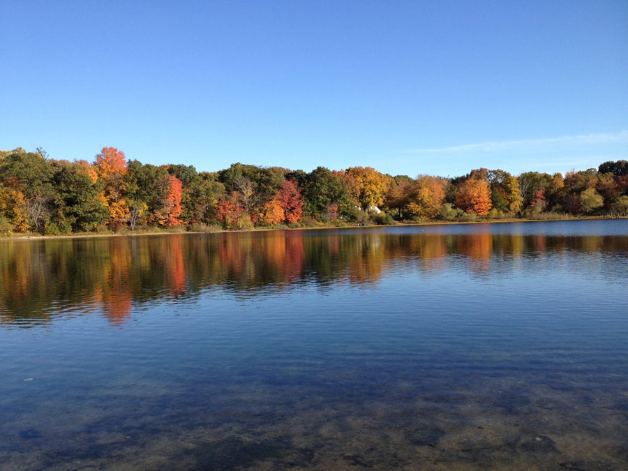
Middle Island is a hamlet and census-designated place in the Town of Brookhaven in Suffolk County, near the geographic center of Long Island. Centered along Middle Country Road, the community developed as an inland farming, stagecoach, postal and trading settlement before gradually becoming the suburban community seen today.
Middle Island had 10,546 residents in the 2020 Census and covers approximately 8.22 square miles of land. Despite modern residential and commercial development, the hamlet retains a strong connection to its earlier landscape through Artist Lake, the historic Middle Country Road corridor, the old Middle Island Presbyterian Church, local cemeteries and extensive woodland at Prosser Pines Nature Preserve and Cathedral Pines County Park. Its location between communities such as Coram, Ridge, Yaphank and Rocky Point also places Middle Island close to some of central Suffolk’s largest remaining areas of protected open space.
History of Middle Island
Middle Island’s name reflects its position in the interior of Long Island rather than an actual island. The community developed along the old Middle Country Road, the historic east-west route that crossed the center of Long Island and connected settlements in western Suffolk with communities farther east.
Early settlement in the area dates to the 18th century, when farms, homes, taverns and small businesses appeared along the road. The Brewster family was among the early families associated with the community. A Brewster property at what later became an important Middle Island crossroads was already serving travelers as a tavern by the 1740s.
Middle Country Road became particularly important before the railroad era. Stagecoaches carrying passengers, mail, news and goods traveled through Middle Island on their way between western Long Island and communities farther east. Taverns, stores and homes along the route provided stopping places for travelers and helped establish Middle Island as an inland crossroads rather than one of the maritime communities found along the North Shore or South Shore.
An Early Long Island Post Office
Middle Island also played an early role in Long Island’s postal system. A post office was established along the central route in the 1790s. It was initially known as Middletown and then Brookhaven before the postal designation became Middle Island in 1821.
During the early 19th century, mail traveled through the community by stagecoach. The post office moved among local homes and businesses before eventually becoming closely associated with the general store at the crossroads of Middle Country Road and Rocky Point Road. For residents living throughout the surrounding rural countryside, the arrival of the mail coach provided an important connection with New York City and the wider region.
Middle Island Presbyterian Church
Religion also helped establish Middle Island as a recognizable community center. Local residents began organizing a Presbyterian congregation in 1766, when land was provided for construction of a meetinghouse along Middle Country Road. The congregation was formally organized the following year.
The surviving historic church at 271 Middle Country Road was constructed in 1837 in the Federal style. A tower was added in 1863 and a bell followed in 1870. The building served generations of Middle Island residents and became one of the most recognizable structures along the old road.
The Presbyterian congregation eventually moved to a newer church complex in 1966. The 1837 building later became home to another congregation and was added to the National Register of Historic Places in 2005, preserving one of Middle Island’s most important links to its 19th-century community life.
Pfeiffer’s Store and the Old Crossroads
For generations, the intersection of Middle Country Road and Rocky Point Road functioned as the social and commercial center of Middle Island. A building at the crossroads had roots extending into the 18th century and was used at different times as a tavern, stagecoach stop and general store.
Edward Pfeiffer purchased the store in 1892 after having worked there as a young clerk. The business became known as Pfeiffer’s Store and supplied families throughout Middle Island and the surrounding countryside with groceries, shoes, hardware, paint, farm equipment, seeds, fertilizer and other necessities.
The store was also a gathering place. Residents collected their mail, exchanged news, discussed politics and gathered around the potbellied stove. Edward Pfeiffer became Middle Island’s postmaster in 1901, and the post office operated from the store for decades.
Pfeiffer’s Store closed in 1957 as automobiles, shopping centers, supermarkets and suburban development changed the way local residents shopped and traveled. The aging building was ultimately demolished in a controlled burn in 1971, ending the physical presence of a crossroads institution that had helped define Middle Island for generations.
Artist Lake and Alonzo Chappel
Artist Lake is one of Middle Island’s best-known natural landmarks and one of the most recognizable inland lakes in this part of Suffolk County. The approximately 30-acre body of water is a glacial kettle lake, part of the landscape left behind by the glaciers that shaped Long Island.
The lake was known historically as Glover’s Pond and by other local names before becoming known as Artist Lake during the 19th century. The change was closely associated with painter and illustrator Alonzo Chappel, who purchased property in Middle Island in 1869 and established a home overlooking the lake.
Chappel was already a prolific illustrator of American historical subjects. His work appeared in numerous 19th-century histories and included depictions of presidents, military leaders, Revolutionary War scenes, the Civil War and other major events in American history. He lived near the lake until his death in 1887 and is buried in Middle Island’s Union Cemetery.
Other artists also spent time near the lake, and by 1871 newspapers were already referring to the body of water as Artist Lake. The lake remains an important scenic feature of Middle Island and is particularly striking during autumn, when the surrounding foliage is reflected across the water.
An Early Aviation Story at Artist Lake
Artist Lake also became the setting for an unusual episode in the earliest years of powered aviation. On October 27, 1910, aviator Ralph Johnstone was competing in the International Aviation Tournament at Belmont Park in Nassau County when he climbed to an American altitude record of 8,471 feet.
Strong winds carried Johnstone’s aircraft far from the tournament grounds, and he eventually landed near Artist Lake in Middle Island, many miles east of where the flight had begun. The feat came only seven years after the Wright brothers’ first powered flight and at a time when airplanes were still extraordinary sights to most Americans.
A historical marker along Route 25 commemorates Johnstone’s unexpected Middle Island landing, adding an early aviation story to the history surrounding Artist Lake.
Prosser Pines Nature Preserve
Middle Island’s best-known forest has an equally unusual history. In 1812, William Dayton planted white pine seedlings on his family’s Middle Island farm. Over time, the original trees matured, reproduced and spread across the property.
George Prosser purchased the farm in 1889 and protected the growing pine plantation. Some of the trees eventually approached 100 feet in height, while the grove expanded into what Suffolk County describes as the only white pine forest on Long Island and one of the oldest surviving white pine plantations on the eastern seaboard.
Suffolk County purchased the property in 1967 and established Prosser Pines Nature Preserve. Today, it is one of the distinctive destinations included among Long Island’s nature preserves and hiking areas. Visitors can walk beneath the tall trees along a short trail where the dense canopy and thick covering of pine needles create an environment markedly different from the surrounding suburban landscape.
The preserve also provides opportunities for quiet nature observation, seasonal photography and birdwatching. Its relatively short trail makes Prosser Pines particularly well suited to visitors interested in experiencing an unusual Long Island forest without undertaking a lengthy hike.
Cathedral Pines County Park
Adjacent to Prosser Pines is Cathedral Pines County Park, a roughly 320-acre Suffolk County park situated near the headwaters of the Carmans River. Together, the two protected areas preserve a substantial woodland landscape along the southern side of Middle Island and provide some of the hamlet’s best opportunities for outdoor recreation.
Cathedral Pines has woodland trails used for hiking and nature walks, while designated routes also make the park part of Long Island’s broader mountain biking network. Picnicking, playground facilities and seasonal camping add to the park’s recreational appeal.
The name Cathedral Pines is traditionally associated with the towering white pines that reminded members of the Dayton family of the interior of a great cathedral. Although the surrounding area has changed substantially since the trees were first planted more than two centuries ago, the preserved forest remains one of Middle Island’s defining landscapes.
Middle Island and the Long Island Pine Barrens
Middle Island lies within the broader landscape associated with the Long Island Pine Barrens, one of the Island’s most important remaining natural regions. Pine-oak forests, sandy soils, wetlands, kettle depressions and groundwater-dependent ecosystems characterize much of central and eastern Suffolk County.
The surrounding open-space network becomes increasingly extensive east and northeast of Middle Island. Ridge contains large areas of preserved Pine Barrens landscape, while Rocky Point is home to the Rocky Point Pine Barrens State Forest. Farther east, preserved forests continue toward Calverton, Manorville and Riverhead.
For visitors interested in exploring more of this landscape on foot, the Long Island Guide’s hiking trails directory and map brings together trail systems throughout Nassau and Suffolk counties, while the Paumanok Path provides a much longer route through portions of the Pine Barrens on its journey toward Montauk.
The Carmans River Region
The southern side of Middle Island is also connected to the upper watershed of the Carmans River, one of central Suffolk’s defining freshwater systems. From the Middle Island and Yaphank area, the river continues south through preserved woodland and wetlands before eventually reaching the Great South Bay system.
Nearby Yaphank developed historically around the Carmans River and its water-powered mills. South of Yaphank, the river passes through additional parkland before reaching Shirley, where Wertheim National Wildlife Refuge protects thousands of acres of forest, wetlands, marsh and river habitat.
Together, these protected properties help form an ecological corridor extending well beyond Middle Island itself. They also create opportunities throughout the region for hiking, birdwatching, wildlife observation, kayaking and other forms of outdoor recreation.
From Farming Community to Suburb
For much of its history, Middle Island was a sparsely populated farming community surrounded by woods. Agriculture, poultry farming, woodcutting, small stores and roadside businesses supported local families, while Middle Country Road provided the community’s principal connection with neighboring settlements.
The character of Middle Island began changing more rapidly during the 20th century as automobiles replaced stage and wagon travel, electric service reached the community and residential development expanded across central Suffolk County. Farms and woodland were gradually replaced by houses, apartment and condominium communities, shopping centers and other suburban development.
Middle Island nevertheless retained considerably more open space than many communities farther west on Long Island. Large woodland areas, nearby Pine Barrens, county parks, lakes and other undeveloped properties continue to give portions of the hamlet a wooded character despite decades of residential growth.
Community and Local Life
Modern Middle Island is primarily residential, with a mix of single-family homes, townhouse and condominium developments, apartment communities, senior housing and local commercial properties. Shopping and services are concentrated largely along Route 25, or Middle Country Road, while quieter residential streets and wooded properties extend north and south of the highway.
Middle Island sits between several other central Brookhaven communities. Coram and Selden provide additional shopping and services to the west, Ridge lies to the east, Yaphank is to the southeast, and Rocky Point and Miller Place provide access toward the North Shore.
Most of Middle Island is served by the Longwood Central School District, with several of the district’s major school facilities located within the hamlet. The district’s name comes from the historic Longwood Estate associated with the Smith family in the Middle Island and Ridge area. The development of the modern school system became an important part of the area’s transition from scattered rural schoolhouses to a growing suburban community.
Outdoor Recreation
Middle Island’s combination of woodland, parks and nearby protected land makes outdoor recreation one of the strongest reasons to explore the area. Prosser Pines and Cathedral Pines provide convenient local access to nature, while additional hiking trails, nature preserves and Pine Barrens destinations can be found throughout central Suffolk.
Depending on the destination, outdoor activities in the surrounding region include hiking, bicycling, mountain biking, birdwatching, picnicking, nature photography and camping. Park rules and permitted activities vary by property, so visitors should check current regulations before making a special trip.
Golf has also been part of Middle Island’s recreational landscape for decades, with Middle Island Country Club among the familiar local names. Additional public and private options throughout the region can be compared through the Long Island Guide’s golf courses directory.
Nearby Communities and Destinations
Middle Island’s central location makes it practical for exploring several different parts of Suffolk County. To the north, Rocky Point, Miller Place, Mount Sinai and Port Jefferson lead toward Long Island’s North Shore and Long Island Sound. Port Jefferson offers one of the region’s best-known harborfront village centers, with restaurants, shops and ferry activity.
Travel south through Yaphank or Medford and the landscape eventually reaches the South Shore. Patchogue provides a major downtown, restaurant and entertainment district along the Great South Bay region, while Shirley provides access toward Wertheim National Wildlife Refuge and the Atlantic coast beyond.
Heading east from Middle Island leads toward Ridge, Calverton and Riverhead, placing the hamlet between the more densely developed communities of central Suffolk and the increasingly open landscapes of eastern Long Island.
Transportation
Route 25, known locally as Middle Country Road, remains Middle Island’s principal east-west transportation corridor centuries after the road helped establish the original community. Rocky Point Road and Yaphank-Middle Island Road provide important north-south connections, while William Floyd Parkway is accessible a short distance to the east.
The Long Island Expressway can be reached by road to the south, providing the principal limited-access highway connection toward western Long Island and New York City as well as communities farther east.
Middle Island does not have its own Long Island Rail Road station. Depending on destination and service needs, nearby rail options include the station in Yaphank, the larger service center at Ronkonkoma, and service from Port Jefferson. Travelers should compare current schedules and parking arrangements when deciding which station best fits a particular trip.
Middle Island, New York
Key Facts and Details
| Community | Middle Island |
| Community Type | Hamlet and census-designated place |
| Town | Town of Brookhaven |
| County | Suffolk County |
| Region | Central Long Island |
| 2020 Census Population | 10,546 |
| Land Area | Approximately 8.22 square miles |
| Population Density | Approximately 1,283 residents per square mile in 2020 |
| Main Road | Route 25, Middle Country Road |
| Historic Role | Farming, stagecoach, postal, trading and crossroads community |
| Early Post Office | Established along the central Long Island postal route in the 1790s; the Middle Island name was adopted for the post office in 1821 |
| Historic Church | Middle Island Presbyterian Church building, constructed in 1837 and listed on the National Register of Historic Places |
| Historic Community Center | Pfeiffer’s Store at Middle Country Road and Rocky Point Road |
| Notable Lake | Artist Lake |
| Lake Type | Approximately 30-acre glacial kettle lake |
| Artist Lake Name | Associated with 19th-century painter and illustrator Alonzo Chappel and other artists who lived or worked near the lake |
| Notable Artist | Alonzo Chappel, 1828–1887 |
| Aviation History | Aviator Ralph Johnstone landed near Artist Lake after a record-setting altitude flight in 1910 |
| Nature Preserve | Prosser Pines Nature Preserve, included among Long Island’s nature preserves |
| Prosser Pines Origin | White pine seedlings planted by William Dayton beginning in 1812 |
| County Park | Cathedral Pines County Park |
| Cathedral Pines Size | Approximately 320 acres |
| Natural Region | Connected to the broader Long Island Pine Barrens landscape |
| Outdoor Recreation | Hiking, mountain biking, birdwatching, photography, picnicking and camping |
| Golf | Middle Island Country Club and additional courses throughout Long Island |
| School District | Primarily Longwood Central School District |
| Nearby Communities | Coram, Selden, Ridge, Yaphank, Rocky Point and Miller Place |
| Major Highway Access | Road connections to the Long Island Expressway |
| Rail Transportation | No LIRR station within Middle Island; nearby options include Yaphank, Ronkonkoma and Port Jefferson |
| Community Character | Residential and suburban with extensive woodland, historic sites, lakes and nearby protected open space |
Middle Island’s modern suburban landscape still contains reminders of the inland community that developed along Middle Country Road centuries ago. The historic church and old crossroads recall an era of farms, taverns, stagecoaches, country stores and early postal service, while Artist Lake, Prosser Pines, Cathedral Pines and the surrounding Pine Barrens preserve much of the natural character that has long distinguished this part of central Suffolk County. Its position between Coram, Ridge and Yaphank, with convenient routes toward both the North Shore and South Shore, makes Middle Island both a residential center and a useful starting point for exploring the parks, forests, historic communities and natural landscapes of the Town of Brookhaven.
Are you ready for fall on Long Island? Check out these local seasonal guides:
🍎 Apple Picking | 🍂 Fall Festivals & Farm Activities | 👻 Haunted Houses | 🎃 Pumpkin Picking
