
Flanders Bay
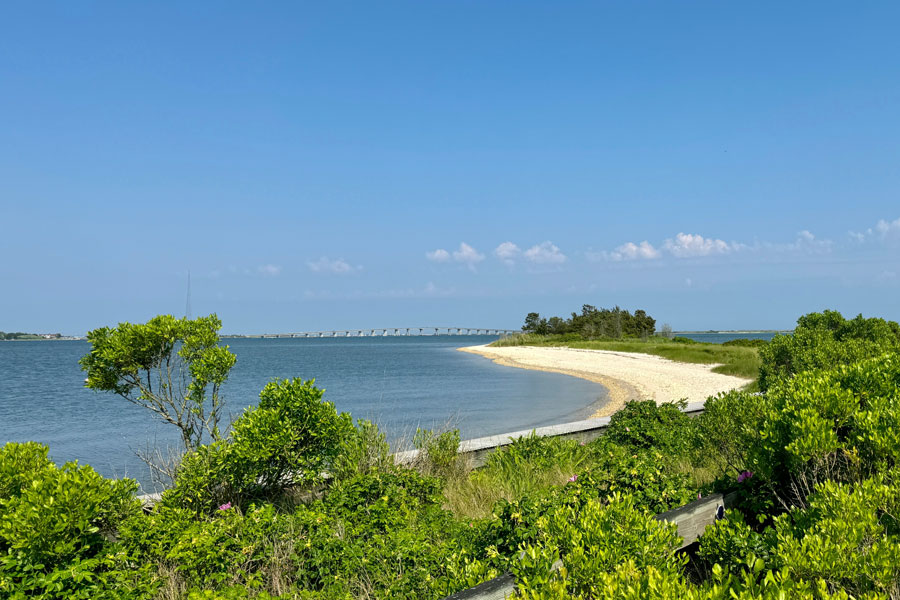
Flanders Bay is a shallow tidal bay at the western end of the Great Peconic Bay system in eastern Suffolk County. The bay lies between Flanders, Riverhead and Riverside to the north and the South Fork communities of Hampton Bays and East Quogue to the south.
The bay receives the eastern flow of the Peconic River and connects the river’s freshwater watershed with the larger Peconic estuary. Its shallow waters, tidal marshes, wetlands and protected shoreline provide important habitat for fish, shellfish, birds and other coastal wildlife.
Location and Geography
Flanders Bay occupies the western end of the Great Peconic Bay, near the point where the North Fork and South Fork begin to separate. The northern shoreline includes Riverhead and the communities around the Peconic River, while the southern shoreline is associated with Flanders, Hampton Bays and the mainland side of the South Fork.
The bay is relatively shallow and sheltered compared with the open Atlantic Ocean. Its shoreline includes tidal wetlands, marshes, creeks, coves and developed waterfront areas, with the exact character changing between the river mouth near Riverhead and the more open waters farther east.
Connection to the Peconic River
The Peconic River is the most significant freshwater waterway connected to Flanders Bay. After flowing eastward through wetlands, Pine Barrens habitats and the Riverhead area, the river reaches its tidal mouth near Indian Island and empties into the bay.
This connection makes Flanders Bay an important receiving water for the Peconic River watershed. Freshwater inflow, tidal exchange and runoff from surrounding land all influence the bay’s water quality, habitats and ecological conditions.
Wetlands and Wildlife Habitat
Flanders Bay contains a mixture of open water, salt marsh, tidal creek and shoreline habitat. These environments support fish, waterfowl, wading birds, shorebirds, turtles, crabs and other wildlife that depend on shallow coastal waters and wetlands.
The bay is also part of the larger Peconic Estuary, an important coastal ecosystem recognized for its shellfish beds, wetlands, submerged aquatic vegetation and recreational waters. Coastal conservation and water-quality programs monitor the estuary to help protect habitat and public use.
Parks and Public Access
Indian Island County Park is located near the mouth of the Peconic River along Flanders Bay. The park provides access to a natural coastal setting with camping, recreation areas, shoreline views and opportunities to observe the surrounding wetlands and estuarine environment.
Other access points in the surrounding Riverhead, Flanders and Hampton Bays area may provide opportunities for boating, fishing, kayaking, wildlife observation and waterfront recreation. Access rules, launch locations, parking availability and seasonal restrictions vary by property, so visitors should follow posted regulations and confirm current conditions before traveling.
Boating and Fishing
Flanders Bay’s sheltered waters are used for recreational boating, kayaking, canoeing and fishing. The bay and its connected creeks provide access to a broader network of waterways, although boaters should be prepared for shallow areas, changing tides, marsh channels and shifting navigational conditions.
Fishing and shellfishing opportunities are subject to New York State and Suffolk County regulations. Seasonal closures, health advisories, shellfish restrictions and water-quality conditions can change, so anglers and harvesters should check current official guidance before entering the water or collecting marine life.
Connection to the Peconic Estuary
Flanders Bay forms part of the interconnected Peconic Estuary, which includes the Great Peconic Bay, Little Peconic Bay, Gardiners Bay and numerous smaller bays, harbors, rivers and tidal wetlands. The estuary supports commercial and recreational fishing, shellfish resources, boating, tourism and wildlife habitat throughout eastern Suffolk County.
Although Flanders Bay is sometimes described as the western end of Great Peconic Bay, the names used for the area can vary between maps, nautical references and local descriptions. The bay is best understood as a distinct western embayment within the broader Great Peconic Bay and Peconic Estuary system.
Flanders Bay
Key Facts & Details
| Official name | Flanders Bay |
| Type | Shallow tidal bay and estuarine embayment |
| Location | Western end of the Great Peconic Bay in eastern Suffolk County |
| Primary connected waterway | Peconic River |
| Part of | Great Peconic Bay and the Peconic Estuary |
| Nearby communities | Flanders, Riverhead, Riverside, Hampton Bays and East Quogue |
| County | Suffolk County |
| Landscape | Open bay, tidal marshes, wetlands, tidal creeks and developed waterfront areas |
| Major public area | Indian Island County Park |
| Recreation | Boating, kayaking, canoeing, fishing, camping, wildlife observation and waterfront recreation |
| Ecological importance | Provides estuarine habitat and receives freshwater inflow from the Peconic River watershed |
| Water-quality considerations | Conditions, shellfish regulations and advisories may change; visitors should check current official guidance |
| Related waterway | Peconic River |
| Related guide | Bays, Harbors, Inlets and Waterways |
Flanders Bay is an important part of Long Island’s eastern water geography, connecting the Peconic River with the Great Peconic Bay and the wider Peconic Estuary. Its sheltered waters, tidal wetlands and shoreline habitats support recreation, wildlife and the communities surrounding Riverhead and the South Fork. Visitors exploring Flanders Bay should use designated public access areas, follow park and boating regulations, and check current water-quality and shellfish advisories before fishing, boating or entering the water. The bay can also be explored as part of a broader trip that includes the Peconic River, Riverhead, Indian Island County Park and other East End waterways.
Are you ready for fall on Long Island? Check out these local seasonal guides:
🍎 Apple Picking 🍓 Strawberry Picking 🎃 Pumpkin Picking 👻 Haunted Houses 🍂 Farm Festivals
