
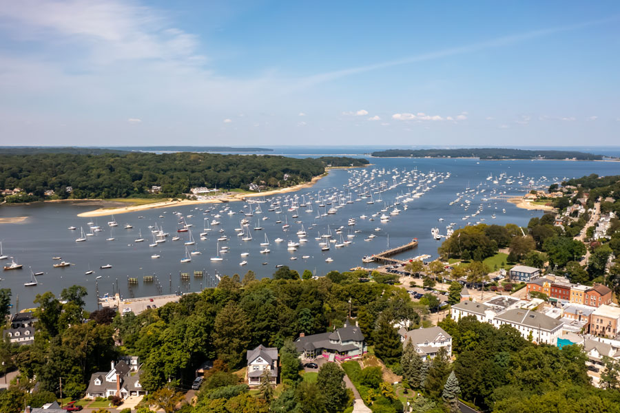
Northport Bay is a scenic tidal bay along Long Island’s North Shore in Suffolk County, New York. Located within the Town of Huntington, the bay is bordered by the waterfront communities of Northport, Asharoken, and the surrounding Eaton’s Neck peninsula. Its protected waters, wooded shoreline, recreational boating activity, and historic maritime connections make it one of the defining natural features of western Suffolk County’s northern coastline.
Northport Bay is part of a larger interconnected system of tidal waterways that includes Northport Harbor, Centerport Harbor, Huntington Bay, and Long Island Sound. The bay opens westward into Huntington Bay, which provides its connection to the Sound. This arrangement creates relatively sheltered conditions compared with the open waters farther offshore, helping explain why the area has attracted sailors, fishermen, boat owners, and waterfront residents for generations.
Although Northport Bay is best known for recreational boating, its significance extends beyond the vessels that occupy its waters during the warmer months. The bay supports marine life, provides habitat for coastal birds, influences the surrounding communities’ geography, and contributes to the historic identity of Long Island’s North Shore. Visitors can experience its scenery from public waterfront locations, while boaters and paddlers can explore portions of the bay from the water when conditions and access arrangements permit.
Geography and Location of Northport Bay
Northport Bay occupies a sheltered coastal basin along the northern shoreline of Long Island. The narrow landmass extending through Asharoken toward Eaton’s Neck helps separate the bay from the more exposed waters of Long Island Sound, creating a distinctive arrangement of peninsulas, coves, harbors, and tidal channels.
The bay’s western entrance connects with Huntington Bay. To the southeast, Northport Harbor extends toward the historic waterfront of the Village of Northport. Centerport Harbor is another adjoining waterway within the broader coastal system, while smaller coves and inlets provide additional sheltered areas around the shoreline.
The surrounding landscape reflects the glacial origins of Long Island. Wooded hills, irregular shorelines, coastal slopes, and sheltered valleys distinguish this portion of the North Shore from the flatter coastal plains and barrier islands commonly associated with the South Shore.
Unlike a freshwater lake, Northport Bay is a tidal saltwater environment. Its water levels, currents, and marine conditions are influenced by tides moving through the connected harbor system and Long Island Sound. These natural processes affect boating, fishing, shoreline habitats, and the distribution of marine life throughout the bay.
Native American History and Early Settlement
Long before European settlement, the shoreline surrounding Northport Bay was part of the homeland of the Matinecock people and other Indigenous communities of northern Long Island. Coastal waters provided important resources, including fish, shellfish, and transportation routes, while nearby forests and upland areas supported additional food gathering and seasonal activities.
The bay and surrounding waterways were central to the region’s early geography because travel by water was often easier than movement through the heavily wooded interior. Protected coves and natural landing places provided opportunities for fishing, trade, and communication between shoreline settlements.
During the seventeenth century, European settlers began acquiring and occupying land around what would become Huntington and Northport. Historical land transactions involving Indigenous leaders, including Chief Asharoken, became part of the documented colonial history of the surrounding peninsula and coastline.
The names Asharoken and Eaton’s Neck continue to reflect different chapters of this history. The geography of Northport Bay, however, predates these settlements by thousands of years and remains an enduring reminder of the area’s natural and Indigenous heritage.
Northport Bay and the Maritime History of Northport
The development of Northport was closely connected to the protected waters of Northport Harbor and the surrounding bay system. During the nineteenth century, the community became an active maritime center, with shipbuilding, commercial transportation, fishing, and coastal trade contributing to its growth.
Before modern highways and widespread automobile ownership, Long Island’s waterways were essential transportation corridors. Coastal vessels moved agricultural products, lumber, manufactured goods, and passengers between local ports and larger markets around New York Harbor and Long Island Sound.
Northport’s sheltered harbor supported this activity, while the larger bay provided access to the surrounding regional waterways. The relationship between the harbor and the bay helped establish Northport as an important waterfront settlement within the Town of Huntington.
As transportation patterns changed during the late nineteenth and twentieth centuries, the local waterfront gradually became less dependent on commercial shipping. Recreational boating, waterfront residences, restaurants, and community activities assumed greater importance.
Today, the historic village waterfront retains much of its maritime atmosphere. Boats remain a prominent part of the scenery, and visitors can still appreciate the relationship between the village’s development and the surrounding tidal waters.
Understanding Northport Bay and Northport Harbor
Northport Bay and Northport Harbor are closely connected, but they are not identical geographical features. The distinction is useful for visitors researching the waterfront, boaters planning navigation, and anyone interested in understanding the area’s coastal geography.
Northport Bay is the larger body of water extending westward toward Huntington Bay. Northport Harbor is the more enclosed harbor area at the southeastern end of the bay, adjoining the Village of Northport’s waterfront.
The village’s public waterfront, commercial establishments, and harbor facilities are primarily associated with Northport Harbor. The broader bay includes additional open water, boating areas, and shoreline extending toward Asharoken and the surrounding peninsula.
Both waterways are part of the Northport Bay complex, which also encompasses nearby tidal channels, coves, and adjoining harbors. Their shared geography contributes to the region’s popularity as a recreational boating destination.
Boating, Sailing, and Marina Activity
Recreational boating is among the most visible activities associated with Northport Bay. During spring, summer, and early autumn, sailboats, motorboats, fishing vessels, and other recreational craft can be seen traveling through the bay or occupying designated mooring and anchorage areas.
The bay’s sheltered setting makes it attractive to boaters, although conditions can change considerably with wind, tides, vessel traffic, and weather. The entrance from Huntington Bay provides access to Long Island Sound and the broader network of waterways serving northern Long Island and coastal Connecticut.
Marinas, yacht clubs, private docks, and mooring facilities support the surrounding boating community. Some facilities provide seasonal slips, launch services, storage, or other marine services, while others are reserved for members or private property owners.
Northport Harbor is particularly associated with the village’s boating activity, while Northport Bay offers additional waters for sailing and recreational cruising. Navigators must remain aware of marked channels, shallow areas, navigation aids, and the possibility of heavy recreational traffic.
Water depths vary throughout the bay, and some areas are considerably shallower than others. Mariners should consult current nautical charts, tide information, navigation notices, and local regulations rather than relying solely on the bay’s generally protected appearance.
Kayaking, Paddleboarding, and Small Watercraft
Northport Bay and its connected waterways also appeal to kayakers, paddleboarders, and other small-watercraft enthusiasts. Paddling can provide a different perspective on the shoreline, allowing visitors to observe waterfront homes, wooded slopes, boats, and coastal wildlife from the water.
Protected coves may offer comparatively calm conditions, particularly during periods of light wind. Nevertheless, Northport Bay is an active tidal waterway rather than a controlled recreational pond. Currents, wakes from passing vessels, and changing weather can create hazardous conditions for inexperienced paddlers.
Launching should take place only from authorized public facilities or locations where permission has been obtained. Not every beach, dock, marina, or waterfront access point is open to the general public.
Visitors planning to paddle should review current launch rules, wear appropriate personal flotation devices, consider tidal conditions, and remain visible to larger vessels. The most suitable routes depend on weather, experience, and the location of an authorized launch site.
Fishing in Northport Bay
Fishing has long been associated with Northport Bay and the surrounding waters of Long Island Sound. The bay’s tidal environment provides habitat for a variety of saltwater fish, attracting anglers who fish from boats and authorized shoreline locations.
Striped bass, bluefish, summer flounder commonly known as fluke, and other coastal species may be encountered in the regional waters depending on the season. The availability of particular species changes with water temperature, migration patterns, habitat conditions, and fishing regulations.
Shore fishing opportunities depend on public access rules, and some waterfront locations prohibit fishing or restrict it to designated areas. Anglers should not assume that a visible shoreline, private dock, or residential beach is open for recreational use.
New York’s marine fishing rules govern recreational saltwater fishing, including species-specific seasons, minimum sizes, and possession limits. Recreational marine anglers may also be required to register with the state’s Marine Recreational Angler Registry, depending on the type of fishing and applicable exemptions.
Because regulations can change, anglers should consult the New York State Department of Environmental Conservation before fishing or keeping their catch.
Shellfish Habitat and Harvesting Restrictions
Shellfish are an important component of the Northport Bay ecosystem. Clams and other shellfish help connect the bay’s natural food web with its long history of coastal harvesting and maritime activity.
However, the presence of shellfish does not mean they can legally or safely be collected. Portions of Northport Bay, Northport Harbor, and adjoining waterways are subject to state shellfish-harvesting closures intended to protect public health.
New York State maintains year-round closures covering designated portions of Northport Bay and Northport Harbor, along with seasonal restrictions in certain nearby waters. Closure boundaries are defined geographically and should be checked against current official maps.
Visitors should never harvest clams, oysters, or other shellfish without confirming that the specific location is open and that all applicable licensing and harvesting requirements are satisfied.
Current closure information is available through the New York State Department of Environmental Conservation’s shellfish closures page.
Marine Wildlife and Coastal Ecology
Northport Bay is more than a recreational waterway. Its tidal waters, shallow coastal areas, and shoreline habitats form part of the broader Long Island Sound estuarine ecosystem.
Fish, shellfish, crabs, and other marine organisms occupy different portions of the bay depending on water depth, bottom conditions, salinity, and seasonal changes. These species contribute to a complex food web supporting larger fish and coastal birds.
Birdwatchers may encounter gulls, cormorants, herons, egrets, and various waterfowl around the bay and its adjoining shoreline habitats. Migratory birds use Long Island’s coastal environment during different times of the year, making spring and autumn particularly interesting periods for wildlife observation.
Shoreline vegetation and tidal wetlands also perform important environmental functions. These areas can provide shelter for juvenile marine organisms, help stabilize portions of the shoreline, and contribute to the ecological health of the surrounding waterways.
Wildlife observation is best conducted from public locations or authorized vessels while maintaining a respectful distance from animals and sensitive habitats.
Water Quality and Environmental Protection
Maintaining water quality is an ongoing concern throughout Northport Bay and the surrounding harbor system. Like other developed coastal watersheds on Long Island, the area is influenced by stormwater runoff, shoreline development, wastewater management, vessel activity, and changing environmental conditions.
Pollutants entering the watershed can eventually reach tidal waterways through drainage systems, groundwater, streams, and surface runoff. Excess nutrients may contribute to water-quality problems, including conditions that affect marine habitats and the suitability of certain waters for recreational or shellfish-related uses.
Environmental management therefore involves more than protecting the visible shoreline. Watershed planning, monitoring, responsible boating practices, habitat preservation, and improvements to pollution controls all play a role in protecting the bay.
The Town of Huntington and state environmental agencies recognize the broader Northport Bay complex as an interconnected system that includes Northport Harbor, Centerport Harbor, and adjoining coves and tidal waters.
Because water-quality conditions can change, visitors should consult current public health advisories before swimming, shellfishing, or participating in activities that involve direct contact with the water.
Northport Village Waterfront and Scenic Views
For visitors without a boat, the historic Village of Northport provides one of the most accessible ways to experience the area’s maritime setting.
Northport’s waterfront offers views of the adjoining harbor, moored vessels, and surrounding coastal landscape. Its traditional downtown includes restaurants, shops, and community gathering places that contribute to the village’s popularity as a North Shore destination.
Northport Village Park is a well-known public gathering area overlooking the harbor. Visitors can enjoy the waterfront atmosphere, observe boats, and explore the nearby village center without needing access to a private marina or waterfront property.
Although the park overlooks Northport Harbor rather than the central open waters of Northport Bay, the two waterways are directly connected and share the same maritime landscape.
The village is particularly appealing during pleasant spring and autumn weather, when visitors can combine waterfront sightseeing with dining, shopping, or a leisurely walk through the historic downtown.
Asharoken and the Eaton’s Neck Peninsula
The northern shoreline of Northport Bay is closely associated with Asharoken, an incorporated village occupying a narrow coastal strip between the bay and Long Island Sound.
This unusual geography creates one of the most distinctive coastal settings on Long Island. In portions of Asharoken, the roadway follows a narrow corridor with the bay on one side and the Sound on the other.
Beyond Asharoken lies Eaton’s Neck, a peninsula characterized by wooded residential areas, shoreline properties, and a strong connection to the surrounding waters.
The peninsula’s geography helps shelter Northport Bay while also contributing to the area’s scenic character. However, much of the waterfront is residential or privately controlled, and visitors should respect posted restrictions and property boundaries.
Public beach and shoreline access in the surrounding Town of Huntington is subject to specific rules, including seasonal permits, parking restrictions, and facility operating conditions. A location that appears accessible from a road may not be open for public beach use.
Public Beaches, Boat Ramps, and Shoreline Access
Public access to the Northport Bay area is available through a combination of village waterfront spaces, town-managed facilities, and authorized boat-launch locations. However, access arrangements vary considerably across the shoreline.
The Town of Huntington maintains several beaches and boat ramps in the surrounding region, including facilities associated with Asharoken and Eaton’s Neck. Some are intended primarily for town residents, and seasonal parking or boat-launch permits may be required.
Asharoken Beach and Hobart Beach are among the town-managed shoreline facilities in the broader peninsula area. Their specific locations, access requirements, and permitted activities should be confirmed before visiting.
Not every town beach is suitable for every activity. Swimming, fishing, kayaking, launching motorboats, and general shoreline access may be governed by different rules at the same facility.
Visitors can review the Town of Huntington’s official beach and boat ramp information for current permit requirements, operating conditions, and public access details.
Seasonal Conditions Around Northport Bay
Northport Bay changes noticeably throughout the year. Spring brings increasing boating activity, seasonal wildlife movement, and the gradual reopening of marine facilities following winter.
Summer is typically the busiest recreational season. Sailboats, motorboats, kayaks, and fishing vessels share the waterways, while the surrounding villages and waterfront destinations attract residents and visitors enjoying warmer weather.
Autumn offers a different atmosphere. Wooded hillsides surrounding portions of the bay display seasonal foliage, and cooler temperatures can make waterfront walks and photography particularly appealing. Recreational boating continues during suitable conditions, although many seasonal facilities gradually reduce operations.
Winter brings quieter waterfront conditions and the possibility of ice formation in sheltered areas during periods of sustained cold weather. Navigation and recreational activity may be affected by storms, freezing temperatures, and seasonal closures.
Regardless of the season, weather forecasts, wind conditions, and tidal information should be considered before undertaking any activity on the water.
Getting to Northport Bay
Northport Bay is located in the Town of Huntington in western Suffolk County. Visitors traveling by car can reach the surrounding communities through regional highways and local North Shore roadways.
New York State Route 25A provides an important east-west connection through the broader North Shore region. Local roads lead toward Northport Village, Asharoken, and the Eaton’s Neck peninsula.
The Long Island Rail Road serves the surrounding area through its Port Jefferson Branch, including Northport Station. The station is inland from the waterfront, so travelers generally need additional transportation to reach the harbor or other shoreline destinations.
Visitors arriving by boat should consult current marine charts and navigation information. Northport Bay is reached through Huntington Bay, and access to individual marinas, mooring areas, and docks depends on local rules and availability.
Because the bay covers a substantial area rather than a single park or attraction, travelers should select a specific destination before beginning their trip. Northport Village Park, an authorized boat ramp, a marina, or a permitted shoreline access point may each require a different route.
Exploring the Surrounding North Shore Communities
Northport Bay is closely connected to several established North Shore communities. Northport provides a historic downtown and waterfront setting, while Asharoken and Eaton’s Neck offer a different perspective on the region’s coastal geography.
To the south and west, Centerport is another waterfront community associated with the broader harbor system. Its shoreline and residential areas reflect the same combination of protected waters, wooded terrain, and maritime history found around Northport Bay.
Farther inland, East Northport provides commercial and residential connections to the surrounding area, while Huntington offers a larger downtown district with dining, shopping, cultural attractions, and additional connections to the North Shore’s history.
Together, these communities help make Northport Bay more than a destination for boat owners. Its waterfront scenery, natural environment, and historical connections form part of a broader visitor experience along Long Island’s North Shore.
Northport Bay, Suffolk County, New York
Key Facts and Details
| Official Name | Northport Bay |
| Location | North Shore of Suffolk County, Long Island, New York |
| Municipality | Town of Huntington |
| County | Suffolk County |
| Geographic Region | North Shore of Long Island |
| Waterbody Type | Tidal saltwater bay and natural harbor system |
| Primary Water Connection | Huntington Bay |
| Connection to Long Island Sound | Through Huntington Bay |
| Adjoining Harbor | Northport Harbor |
| Broader Bay Complex | Includes Northport Harbor, Centerport Harbor, and surrounding tidal coves and waterways |
| Nearby Communities | Northport, Asharoken, Eaton’s Neck, and Centerport |
| Geographic Origins | Coastal landscape shaped by glacial processes and subsequent tidal activity |
| Historical Significance | Indigenous coastal resource area and important waterway associated with Northport’s maritime development |
| Indigenous Heritage | Associated with the Matinecock people and other Indigenous communities of northern Long Island |
| Known For | Boating, sailing, fishing, scenic waterfront views, and maritime history |
| Popular Recreational Activities | Boating, sailing, kayaking, paddleboarding, fishing, photography, and wildlife observation |
| Boating Facilities | Marinas, yacht clubs, private docks, moorings, and authorized launch facilities in the surrounding area |
| Navigation Conditions | Protected in many conditions, but subject to tides, wind, shallow areas, and recreational vessel traffic |
| Fishing Species | Regional saltwater species include striped bass, bluefish, fluke, and other seasonally available fish |
| Fishing Regulations | New York marine fishing rules and applicable registration requirements |
| Shellfish Harvesting | Subject to year-round and seasonal closures in designated portions of the bay and adjoining waters |
| Marine Habitat | Tidal waters, fish habitat, shellfish resources, and shoreline ecosystems |
| Birdlife | Waterfowl, gulls, cormorants, herons, egrets, and migratory coastal birds |
| Environmental Concerns | Water quality, stormwater runoff, nutrient pollution, shoreline erosion, and habitat protection |
| Public Waterfront Viewing | Northport Village waterfront and other authorized public shoreline locations |
| Nearby Waterfront Park | Northport Village Park, overlooking adjoining Northport Harbor |
| Nearby Peninsula | Asharoken and Eaton’s Neck |
| Beach Access | Varies by location; seasonal permits and restrictions may apply |
| Boat Launch Access | Authorized public and private facilities; permit requirements vary |
| Best Boating Season | Generally spring through early autumn, subject to conditions |
| Best Time for Waterfront Sightseeing | Spring, summer, and autumn, with year-round scenic interest |
| Regional Road Access | New York State Route 25A and local North Shore roads |
| Nearby Rail Service | Long Island Rail Road Port Jefferson Branch via Northport Station |
| Parking | Varies by destination; municipal and seasonal permit rules may apply |
| Public Access | Available at designated public waterfront and recreational facilities; much of the surrounding shoreline is privately owned |
| Swimming | Only at authorized swimming locations when officially open and water conditions permit |
| Shellfish Closure Information | New York State Department of Environmental Conservation |
| Beach and Boat Ramp Information | Town of Huntington |
| Visitor Considerations | Check weather, tides, navigation conditions, public access rules, and seasonal restrictions |
Northport Bay remains one of the defining natural waterways of Suffolk County’s North Shore, combining a rich maritime history with scenic coastal geography, recreational boating, fishing opportunities, and important marine habitats. Its connection to Northport, Asharoken, and Eaton’s Neck gives the bay a distinctive place in the region’s cultural and environmental landscape. Whether experienced from the historic village waterfront, an authorized shoreline location, or a boat traveling through its protected waters, Northport Bay offers a lasting perspective on the maritime character of Long Island.