
Bethpage Bikeway – Nassau County
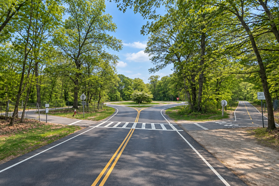
Bethpage Bikeway is a paved multi-use trail extending approximately 12.5 miles through central Nassau County, connecting Massapequa in the south with Syosset in the north. Along the way, the route passes through or alongside some of Long Island’s most important public open spaces, including Massapequa Preserve, Bethpage State Park and Trail View State Park.
Although the name suggests a trail intended only for bicycles, the Bethpage Bikeway is used by walkers, runners and in-line skaters as well. During suitable winter conditions, portions of the route can also be used for cross-country skiing and snowshoeing. Its combination of paved trail, wooded parkland and connections between communities makes it one of the most useful recreational paths in Nassau County.
A North-South Trail Through Nassau County
The Bethpage Bikeway runs roughly north to south across Nassau County. Its northern reach extends to the area of the Syosset Long Island Rail Road station, while the trail continues south through Trail View State Park and Bethpage State Park before reaching Massapequa.
The bikeway is approximately 12.5 miles long, making it substantial enough for a longer recreational ride while also allowing visitors to use individual sections for shorter walks, runs or bicycle trips.
Much of the route is separated from regular automobile traffic and travels through parkland or alongside protected open space. However, the entire bikeway should not be thought of as one uninterrupted off-road trail. The northern extension includes street crossings and connecting sections where users must pay attention to traffic, pavement markings and signals.
Massapequa and the Southern Portion of the Bikeway
At its southern end, the Bethpage Bikeway reaches Massapequa and the extensive trail system associated with the Peter J. Schmitt Massapequa Preserve. The preserve protects approximately 423 acres of freshwater wetlands, ponds, streams and wooded habitat and is one of the largest natural areas on Nassau County’s South Shore.
This is one of the most scenic portions of the overall route. Riders and walkers travel through wooded surroundings that can feel surprisingly removed from the suburban neighborhoods and major roads surrounding the preserve.
Massapequa Preserve also carries the Nassau-Suffolk Greenbelt Trail, creating an important distinction for visitors. The Bethpage Bikeway is primarily a paved multi-use route, while the Greenbelt Trail is principally a hiking route that continues much farther north across Long Island. The two trails travel near one another through portions of the corridor but are not the same trail.
Through Bethpage State Park
One of the central sections of the bikeway passes through Bethpage State Park, the large state recreation area near Farmingdale. The park is best known for its five public golf courses, including the internationally known Bethpage Black Course, but it also contains an extensive network of hiking and bicycling trails.
Within the park, the Bethpage Bikeway intersects or approaches several other marked trails. Visitors should pay attention to trail signs and maps because the park contains hiking routes, mountain biking trails, bridle paths and other recreational paths in addition to the paved bikeway.
Bethpage State Park is also a convenient place to access the bikeway because it provides parking and other park facilities. Vehicle entrance fees may apply at certain times of the year.
The Northern Extension and Trail View State Park
The Bethpage Bikeway originally centered on the route south of Bethpage State Park. A major extension completed during 2013 and 2014 carried the trail north through portions of Trail View State Park and ultimately toward the Syosset train station.
Trail View State Park itself is a long, narrow park protecting approximately 400 acres of open space through central Nassau County. Its landscape includes hardwood forest, marshes, fields and rolling terrain, providing an important green corridor through an otherwise heavily developed part of Long Island.
The Bethpage Bikeway extension through this area was constructed and is maintained by the New York State Department of Transportation. The off-road portions through the parks were largely completed in 2013, followed by additional road-crossing markings, trailheads and signal improvements in 2014.
Riders traveling the entire northern portion should be prepared for roadway crossings and some connecting sections that differ from the more secluded paved portions farther south. Traffic conditions can change, so cyclists should obey signs and signals and use additional caution whenever the route meets public roads.
Cycling the Bethpage Bikeway
The trail’s length makes it suitable for a wide range of bicycle trips. A full end-to-end ride covers approximately 12.5 miles in one direction, meaning cyclists returning to their starting point by bicycle should plan for a trip of roughly 25 miles.
The route is not uniformly flat. Areas around Bethpage and Trail View contain rolling terrain, and riders can encounter gradual climbs and descents. Recreational cyclists can comfortably use shorter portions of the trail, while more experienced riders may combine the bikeway with other local roads and trails for a longer outing.
Because the path is shared, cyclists should expect walkers, runners and other trail users. Slowing down when approaching pedestrians, announcing passes and keeping right when practical help make the trail safer for everyone.
Walking, Running and Other Uses
A bicycle is not required to enjoy the Bethpage Bikeway. The paved surface makes many sections popular for walking and jogging, and visitors can enter at numerous points rather than traveling the complete route.
New York State Parks identifies bicycling, walking, jogging and in-line skating among the warm-weather uses of the bikeway. When snow conditions permit, cross-country skiing and snowshoeing are also possible on portions of the trail.
Motor vehicles are not permitted on the recreational trail itself, although users encounter roads and vehicle traffic at various crossings along the route.
Bethpage Bikeway and the Greenbelt Trail
The number of trails crossing the same corridor can sometimes create confusion. The Bethpage Bikeway and the Nassau-Suffolk Greenbelt Trail share parts of the same general north-south corridor, but they serve different purposes.
The Nassau-Suffolk Greenbelt Trail is primarily intended for hikers and extends from the South Shore at Massapequa north through Bethpage and Trail View before continuing to Cold Spring Harbor on Long Island’s North Shore. The Bethpage Bikeway, by contrast, is a paved multi-use route designed to accommodate bicycles as well as pedestrians and other non-motorized users.
Trail users should therefore follow the signs for the specific route they intend to use rather than assuming every nearby trail is part of the bikeway.
Access and Parking
Because the Bethpage Bikeway stretches across several communities and parks, there is no single required starting point. Visitors can enter the route from Bethpage State Park, locations along Trail View State Park, Massapequa and other established access points along the corridor.
Bethpage State Park has substantial parking and serves as one of the most recognizable central access locations. Trail View State Park also provides access to the northern portion of the route, while Massapequa Preserve provides several opportunities to reach trails at the southern end of the corridor.
Visitors should observe posted parking restrictions at individual trailheads and surrounding streets. Parking availability, park entrance fees and access conditions can differ depending on the location and season.
What to Know Before You Go
The Bethpage Bikeway passes through several different park systems and developed communities, so conditions can vary considerably along its length. Some sections provide a quiet ride through wooded parkland, while others involve intersections, roadside connections or busier surroundings.
Anyone planning to travel the entire route should review a current trail map beforehand, carry water and allow additional time for road crossings and navigation. New York State Parks also advises visitors to be aware that trail conditions can change.
Bethpage Bikeway – Nassau County
Key Facts & Details
| Feature | Details |
|---|---|
| Trail Name | Bethpage Bikeway |
| Location | Central Nassau County, from Massapequa north through Bethpage State Park and Trail View State Park toward Syosset |
| Length | Approximately 12.5 miles |
| Trail Type | Paved multi-use trail with road crossings and connecting sections |
| Primary Uses | Bicycling, walking, jogging and in-line skating |
| Winter Uses | Cross-country skiing and snowshoeing when conditions permit |
| Motor Vehicles | Not permitted on the recreational trail |
| Major Parks Along Route | Massapequa Preserve, Bethpage State Park and Trail View State Park |
| Northern Reach | Syosset Long Island Rail Road station area |
| Southern Reach | Massapequa and the Massapequa Preserve corridor |
| Surface | Primarily asphalt-paved |
| Difficulty | Generally moderate, with rolling terrain, road crossings and longer distances for end-to-end users |
| Managing Agencies | New York State Department of Transportation, New York State Parks and local park agencies along the route |
| Bethpage State Park Information | (516) 249-0701 |
The Bethpage Bikeway provides something increasingly valuable on Long Island: a long recreational corridor that allows cyclists, runners and walkers to travel for miles through parks and preserved open space rather than remaining entirely on ordinary streets. From the wetlands and woods around Massapequa to Bethpage State Park and the rolling landscape of Trail View, the route connects several of Nassau County’s most important outdoor recreation areas and offers visitors an unusually long way to explore central Long Island under their own power.
Are you ready for fall on Long Island? Check out these local seasonal guides:
🍎 Apple Picking 🍓 Strawberry Picking 🎃 Pumpkin Picking 👻 Haunted Houses 🍂 Farm Festivals
