
The Smithtown Bay
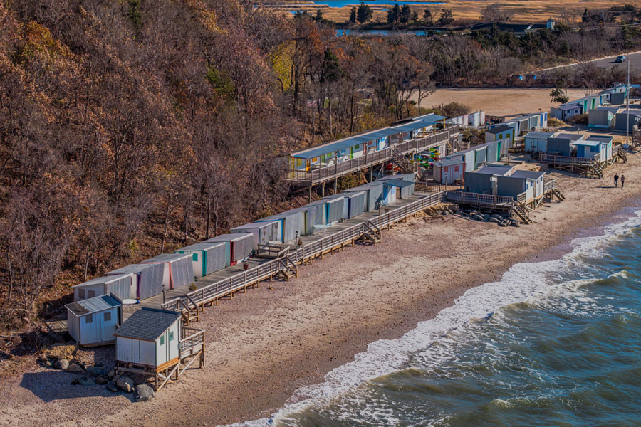
Smithtown Bay is a broad coastal embayment along Long Island’s North Shore in Suffolk County. Opening into Long Island Sound, the bay extends between Eatons Neck to the west and Crane Neck to the east, encompassing a varied shoreline of beaches, bluffs, river mouths, tidal wetlands, parkland, and residential communities.
The bay is closely connected with the Town of Smithtown and communities including Kings Park, Nissequogue, and Stony Brook. The Nissequogue River empties into its western side, while Stony Brook Harbor forms a protected tidal harbor along the eastern portion of the bay. Together, these waterways create one of the most geographically and environmentally varied coastal areas on the North Shore.
Geography and Coastal Setting
Smithtown Bay is part of the larger Long Island Sound estuary, but the headlands surrounding the bay partially shelter it from the Sound’s dominant east-to-west tidal movement. Eatons Neck and Crane Neck help define the bay’s outer limits, while smaller points, beaches, and inlets create a more complex shoreline closer to land.
The coast changes considerably from one section to another. High bluffs and elevated parkland overlook parts of the western bay near Kings Park, while lower beaches, dunes, tidal marshes, and riverfront habitat surround the mouth of the Nissequogue River. Farther east, the shoreline leads toward the entrance to Stony Brook Harbor and the coastal communities around Stony Brook and Old Field.
Freshwater entering through the Nissequogue River mixes with the bay’s salt water, creating productive brackish and estuarine environments near the river mouth. Tides, wind, storms, sediment movement, and seasonal changes continually shape the beaches, channels, shoals, and bluff faces surrounding the bay.
Natural Environment
Smithtown Bay supports a variety of marine and shoreline habitats. Sandy and silty bottom areas, nearshore shallows, tidal marshes, beaches, dunes, and rocky sections provide feeding, spawning, nursery, and resting areas for fish, shellfish, shorebirds, and other wildlife.
The Nissequogue River corridor is especially important to the bay’s ecology. Its wetlands and protected shoreline support herons, egrets, osprey, waterfowl, migratory birds, finfish, shellfish, and diamondback terrapins. Protected lands surrounding the river also help preserve a natural connection between inland freshwater habitat and Long Island Sound.
Marine species commonly associated with Smithtown Bay and the surrounding Sound include striped bass, bluefish, summer flounder, scup, blackfish, menhaden, and other seasonal fish. The exact abundance and location of individual species vary with water temperature, tides, baitfish movement, and the time of year.
Beaches and Shoreline Access
Several public parks and beaches provide access to Smithtown Bay or nearby connected waters. Sunken Meadow State Park is the largest and most accessible destination along this section of the coast, offering a Long Island Sound beach, boardwalk, picnic areas, trails, golf, and expansive views across the bay and Sound.
Town-operated waterfront areas include Callahan’s Beach, Short Beach, and the Kings Park Bluff area. These locations provide varying combinations of swimming, fishing, scenic views, picnicking, and shoreline recreation. Access rules differ among state, town, village, and privately operated properties, and some Town of Smithtown beaches and parking areas are primarily intended for residents or require a current parking permit.
Although much of the surrounding coastline is publicly owned parkland, Smithtown Bay does not have one central visitor entrance. The best access point depends on whether a visitor is interested in swimming, hiking, fishing, launching a watercraft, viewing wildlife, or simply seeing the bay from shore.
Fishing and Boating
Smithtown Bay has long been used for recreational fishing, boating, paddling, and other water-dependent activities. Surfcasters fish from accessible shoreline areas, while boat anglers explore the bay’s shoals, channels, river mouth, and deeper water leading into Long Island Sound. Striped bass, bluefish, summer flounder, scup, and blackfish are among the species anglers may pursue during their respective seasons.
The Smithtown Artificial Reef provides additional marine habitat and a destination for boat-based fishing. Managed through the New York State Department of Environmental Conservation’s Artificial Reef Program, the reef contains vessels, barges, steel materials, concrete blocks, and other durable structures placed on the seafloor to create habitat for fish and marine organisms. Boaters should use current nautical charts, reef coordinates, marine forecasts, and appropriate navigation equipment when traveling offshore.
Public boating facilities are found around the Nissequogue River, Kings Park, and Stony Brook Harbor, although channel depth, tides, currents, shoaling, and launch restrictions can affect access. The shallow and environmentally sensitive nature of some areas makes them better suited to kayaks, canoes, and other hand-launched vessels than larger powered boats.
Water Quality and Conservation
Smithtown Bay is part of the larger Long Island Sound watershed and is affected by conditions throughout the surrounding coastal drainage area. Stormwater runoff, groundwater contamination, septic-system discharge, excess nutrients, sediment, shoreline development, and disturbance of wetlands can all influence water quality and habitat health.
The bay’s partially sheltered geography can also reduce water circulation compared with the open Sound. During warm weather, limited mixing can contribute to water-column stratification, in which warmer surface water remains above cooler and saltier bottom water. Under certain conditions, this separation can reduce the amount of dissolved oxygen available in deeper water.
Shellfish harvesting is regulated separately from recreational swimming and fishing. Portions of Smithtown Bay, the Nissequogue River, Stony Brook Harbor, and connected waterways are subject to year-round or seasonal shellfishing closures. Conditions may also produce temporary emergency closures, so harvesters should always consult the New York State Department of Environmental Conservation’s current shellfish closure information before collecting shellfish.
Visitor Tips
Visitors should choose an access point based on the activity they have planned. Sunken Meadow State Park is generally the most practical choice for broad public access, while Town of Smithtown beaches and waterfront parks may have residency, parking-permit, operating-hour, or seasonal restrictions. Current Town park and beach information is available through the Town of Smithtown Parks Department.
Swimming conditions and beach advisories can change after heavy rainfall or water-quality testing. Before entering the water, visitors should check posted signs and review the New York State Coastal Beach Water Quality Status. Anglers and boaters should also review current weather, tides, fishing regulations, launch requirements, and navigation conditions.
Because the bay can experience wind, waves, changing tides, shoaling, and limited visibility, paddlers and operators of small boats should remain close to appropriate access points and carry required safety equipment. Coastal bluffs, dunes, wetlands, nesting areas, and closed sections of shoreline should be respected to protect both visitors and sensitive habitat.
Smithtown Bay
Key Facts and Details
| Category | Details |
|---|---|
| Location | North Shore of Long Island, Suffolk County |
| Waterbody Type | Coastal bay and embayment of Long Island Sound |
| General Boundaries | Eatons Neck to the west and Crane Neck to the east |
| Primary Municipality | Town of Smithtown |
| Connected Waterways | Nissequogue River, Stony Brook Harbor, Sunken Meadow Creek, and Long Island Sound |
| Nearby Communities | Kings Park, Nissequogue, Stony Brook, and Head of the Harbor |
| Major Public Park | Sunken Meadow State Park |
| Other Shoreline Access | Callahan’s Beach, Short Beach, Kings Park Bluff, and nearby river and harbor facilities |
| Popular Activities | Swimming, boating, paddling, fishing, hiking, birdwatching, picnicking, and nature photography |
| Marine Habitat | Sandy and silty bottom, nearshore shallows, tidal wetlands, beaches, dunes, and an artificial reef |
| Commonly Targeted Fish | Striped bass, bluefish, summer flounder, scup, and blackfish |
| Access Considerations | Parking permits, residency rules, entrance fees, operating hours, and seasonal restrictions vary by location |
| Important Safety Checks | Weather, tides, marine forecasts, beach advisories, fishing regulations, and shellfishing closures |
| Official Local Information | Town of Smithtown Parks, Buildings and Grounds |
Smithtown Bay brings together many of the defining features of Long Island’s North Shore, from coastal bluffs and broad Sound views to beaches, tidal wetlands, river habitat, and protected parkland. Its connections with the Nissequogue River, Stony Brook Harbor, and Long Island Sound make the bay an important natural resource as well as a rewarding setting for fishing, boating, wildlife observation, and waterfront recreation.
Are you ready for fall on Long Island? Check out these local seasonal guides:
🍎 Apple Picking 🍓 Strawberry Picking 🎃 Pumpkin Picking 👻 Haunted Houses 🍂 Farm Festivals
