
Nissequogue River
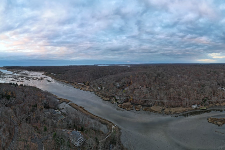
The Nissequogue River is one of Long Island’s best-known and most ecologically significant rivers, flowing through the Town of Smithtown toward Long Island Sound on the North Shore. From its quieter upper reaches near parkland and freshwater habitat to its broader tidal sections near the Sound, the river and its surrounding wetlands, bluffs, and wooded corridors form a distinctive natural landscape that supports wildlife, recreation, and conservation across a broad stretch of Suffolk County.
The river is closely associated with places such as Caleb Smith State Park Preserve, Nissequogue River State Park, and Sunken Meadow State Park. Portions of the river corridor are protected under New York State’s Wild, Scenic and Recreational Rivers System, reflecting its environmental importance and the continuing effort to preserve its character.
History
The Nissequogue River has long been part of Long Island’s natural and cultural history. Indigenous communities lived near and relied on the river long before European settlement, and later generations used the waterway and surrounding land for farming, milling, fishing, and local travel. Over time, growing recognition of the river’s ecological value helped drive efforts to preserve large sections of its corridor.
Today, the river remains one of the North Shore’s most notable protected waterways. Conservation efforts across the watershed focus on habitat preservation, water quality, and limiting development impacts in and around sensitive riverfront areas.
Highlights and Features
The Nissequogue River offers a mix of natural beauty, protected habitat, and outdoor recreation:
- Protected River Corridor: Portions of the Nissequogue are included in New York State’s Wild, Scenic and Recreational Rivers System, helping protect the river’s natural setting and limiting harmful encroachment along key stretches.
- Freshwater and Tidal Habitats: The river corridor includes freshwater reaches upstream, tidal wetlands downstream, wooded areas, sandy shorelines, and bluff-top scenery near the Sound. These varied habitats support birds, fish, reptiles, amphibians, and other native wildlife.
- Connection to Major Parks: The river passes through or alongside some of Long Island’s best-known parklands, including Caleb Smith State Park Preserve, Nissequogue River State Park, and Sunken Meadow State Park.
- Trail Access: Sections of the Long Island Greenbelt Trail connect with nearby parkland along the river corridor, giving hikers access to wooded paths, scenic overlooks, and changing views of the river and Long Island Sound.
- Wildlife and Nature Study: The river system provides important habitat for fish, shellfish, and birdlife, and it is a favored setting for birdwatching, photography, quiet walks, and environmental education.
- Low-Impact Recreation: Depending on the access point, visitors come to the river for hiking, shoreline views, fishing, and in some areas paddling. Launch access, permits, and site rules vary by park or municipality, so it is best to check ahead before visiting.
Landscape and Conservation
The Nissequogue River is part of a larger watershed and estuarine environment that plays a major role in the health of Long Island’s North Shore waters. Its tidal reaches, adjacent marshes, and surrounding uplands help support biodiversity and provide a buffer against erosion and runoff before the river opens into Smithtown Bay and Long Island Sound. Because of its environmental sensitivity, the river has been the focus of long-term public stewardship and monitoring.
Visitors can help protect the river by staying on marked trails, respecting habitat areas, avoiding litter, and following posted rules in nearby parks and preserves. Low-impact recreation and careful land management are important to maintaining the river’s character.
Visitor Tips
There is no single all-purpose public access point for the entire river, so the best way to experience the Nissequogue is usually through nearby parks, preserves, and trail systems. Popular options include Caleb Smith State Park Preserve, Nissequogue River State Park, and Sunken Meadow State Park, each offering a different perspective on the river and surrounding landscape.
Visitors using the Long Island Rail Road may find nearby access via stations such as Kings Park or Smithtown, depending on which section they plan to explore. Parking, trail conditions, and seasonal access vary by location, and rail service details may change, so checking ahead is a good idea.
Because conditions along the river can shift with weather, tides, and season, visitors should be prepared for muddy or uneven trails in some areas and should follow any posted guidance about shoreline or launch access.
Whether viewed from a wooded trail, a marsh edge, or a bluff above the water, the Nissequogue River offers one of Long Island’s most scenic and rewarding natural landscapes, blending quiet beauty with real ecological importance.
Nissequogue River
Key Facts and Details
| Category | Details |
|---|---|
| Location | Town of Smithtown, Suffolk County |
| Region | North Shore of Long Island |
| River Type | Freshwater river in its upper reaches and tidal estuary downstream |
| Watershed Size | Approximately 26 square miles |
| Outlet | Smithtown Bay and Long Island Sound |
| State Protection | Designated portions are protected under the New York State Wild, Scenic and Recreational Rivers System |
| Natural Habitats | Freshwater streams, tidal wetlands, marshes, ponds, woodlands, shorelines, and coastal bluffs |
| Associated Parks | Caleb Smith State Park Preserve, Nissequogue River State Park, and Sunken Meadow State Park |
| Popular Activities | Hiking, paddling, fishing, birdwatching, nature photography, and wildlife observation |
| Public Access | Available through several parks, preserves, trails, and designated launch areas along the river corridor |
| Visitor Considerations | Water levels, tides, permits, parking, and launch conditions vary by location and season |
| Official Information | New York State Department of Environmental Conservation |
From its freshwater headwaters and wooded parklands to its broad tidal marshes near Long Island Sound, the Nissequogue River represents one of the most varied and environmentally important natural corridors on Long Island. Its protected habitats, scenic landscapes, and connections to several major parks make the river an especially rewarding destination for low-impact recreation and a valuable natural resource for future generations.
Are you ready for fall on Long Island? Check out these local seasonal guides:
🍎 Apple Picking | 🍂 Fall Festivals & Farm Activities | 👻 Haunted Houses | 🎃 Pumpkin Picking
