
Moriches Bay
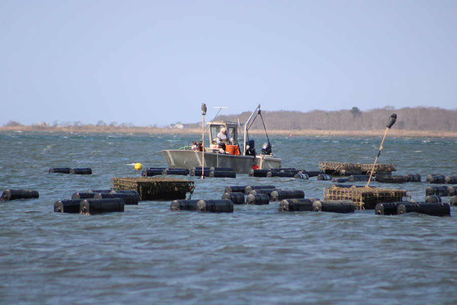
Moriches Bay is a large shallow tidal bay along the eastern portion of Long Island’s South Shore in Suffolk County, New York. Situated between Great South Bay to the west and Shinnecock Bay to the east, it forms part of Long Island’s interconnected barrier-beach lagoon system, separated from the Atlantic Ocean by barrier islands and linked to surrounding waters by bays, canals, and ocean inlets elsewhere along the South Shore. Known for scenic waterfronts, boating culture, fishing opportunities, shellfish waters, and ecological importance, Moriches Bay remains central to the identity and economy of the surrounding coastal communities.
History and Geography
Moriches Bay stretches across the southern edge of eastern Suffolk County and borders communities including Center Moriches, East Moriches, Eastport, Westhampton, and the barrier island areas near Cupsogue Beach and Westhampton Dunes. The bay’s relationship to the ocean has shifted over time as storms, erosion, dredging, and natural coastal processes altered nearby channels and inlets, including the former Moriches Inlet.
The name “Moriches” is generally linked to colonial-era references to a Native American figure or landowner called Meritces or Moriches. Over the centuries, the bay became closely associated with fishing, clamming, boating, and maritime trade. Today, the region remains strongly connected to waterfront living and marine recreation.
Like many South Shore bays, Moriches Bay is relatively shallow and includes a mix of open water, marshlands, tidal creeks, flats, and protected habitat areas. These ecosystems support fish, shellfish, shorebirds, and other marine wildlife while also helping buffer storm impacts and coastal flooding.
Lifestyle and Waterfront Culture
The communities surrounding Moriches Bay are closely tied to boating and waterfront recreation. Residential canals, marinas, docks, and private waterfront homes are common throughout the area, particularly in communities such as Center Moriches and East Moriches. Many residents maintain direct access to the bay for recreational boating, fishing, paddleboarding, and kayaking.
Fishing remains one of the bay’s most popular activities, with anglers targeting striped bass, bluefish, fluke, weakfish, and other seasonal species. Shellfishing and clamming have also long been important to the bay’s economy and heritage, although harvest rules, water-quality closures, and permit requirements can vary, so checking current local guidance before heading out is a good idea.
Although quieter than some of Long Island’s busier waterfront destinations, the Moriches Bay region attracts seasonal visitors seeking beaches, boating access, waterfront dining, and scenic coastal settings. Nearby communities provide restaurants, marinas, bait shops, parks, and public launch areas that support the bay’s active maritime lifestyle, with access and amenities varying by season and municipality.
Parks and Recreation
- Boating and Fishing – Moriches Bay is widely used for recreational boating, fishing, kayaking, paddleboarding, and sailing, with conditions and launch access varying by location.
- Cupsogue Beach County Park – A nearby South Shore beach destination known for swimming, fishing, dunes, and ocean access.
- Salt Marshes and Wildlife Habitats – The bay supports important coastal ecosystems used by migratory birds, juvenile fish, shellfish, and other marine species.
- Waterfront Communities – Nearby hamlets and villages offer marinas, docks, waterfront dining, and scenic residential canals, along with public shoreline access points in select areas.
Environmental Importance
Moriches Bay is an ecologically sensitive coastal environment. Water quality, marshland preservation, shoreline erosion, habitat health, and storm resilience remain ongoing concerns throughout the region. Hurricanes, nor’easters, and changing inlet conditions have periodically reshaped portions of the bay and surrounding barrier islands.
Following storms such as Hurricane Sandy in 2012, major efforts were undertaken to strengthen dunes, restore wetlands, and improve coastal resiliency throughout Long Island’s South Shore bay system. Environmental organizations, local governments, researchers, and conservation groups continue to monitor and protect the health of Moriches Bay and its surrounding habitats.
Transportation and Access
- Road Access: Sunrise Highway and Montauk Highway provide primary east-west access to Moriches Bay communities.
- Rail: Nearby rail access is available via the Long Island Rail Road (LIRR) Montauk Branch, with stations such as Speonk and Westhampton commonly used for the eastern bay area. Service details may change, so check schedules ahead.
- Boat Access: Numerous marinas, launch areas, public docks, and private canals connect residents and visitors directly to the bay. Slip availability, launch fees, and local rules vary.
- Nearby Destinations: The bay is close to Westhampton Beach, Center Moriches, East Moriches, Eastport, Hampton Bays, and the eastern South Fork region.
Vicinity of Moriches Bay
Visitor Snapshot: Moriches Bay
| Feature | Details |
|---|---|
| Location | South Shore of eastern Suffolk County, Long Island |
| Type | Shallow tidal bay within Long Island’s barrier-lagoon system |
| Connected Waters | Linked to the larger South Shore bay system and the Atlantic Ocean through surrounding bays, canals, and maintained ocean inlets |
| Known For | Boating, fishing, shellfish waters, marshlands, and waterfront communities |
| Nearby Communities | Center Moriches, East Moriches, Eastport, Westhampton, and nearby Westhampton Beach |
| Popular Activities | Fishing, kayaking, boating, paddleboarding, wildlife viewing, and seasonal beach trips nearby |
| Waterfront Features | Salt marshes, canals, marinas, docks, tidal creeks, and shallow coastal habitat |
| Environmental Importance | Marine habitats, wetland ecosystems, water-quality concerns, and coastal flood protection |
| Transportation | Sunrise Highway, Montauk Highway, nearby LIRR Montauk Branch stations, and local marinas and launches |
| Community Vibe | Scenic, maritime, relaxed, and nature-oriented |
Moriches Bay remains one of Long Island’s most scenic and ecologically important waterfront regions. From boating and fishing to marshland preservation and coastal living, the bay continues to shape the character of eastern Long Island’s South Shore communities while offering residents and visitors a distinctly maritime setting. Because public access, conditions, and seasonal services can vary, it is wise to check ahead before visiting specific beaches, marinas, or launch points.
Are you ready for fall on Long Island? Check out these local seasonal guides:
🍎 Apple Picking | 🍂 Fall Festivals & Farm Activities | 👻 Haunted Houses | 🎃 Pumpkin Picking
