
Long Island Greenbelt Trail
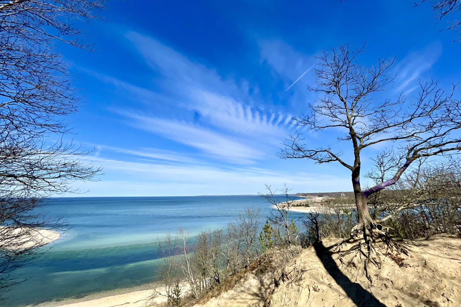
Long Island Greenbelt Trail is one of the region’s best-known long-distance hiking routes, running roughly 31 to 32 miles from Sunken Meadow State Park on the Long Island Sound south to Heckscher State Park on the Great South Bay. Following a north-to-south corridor through central Suffolk County, the trail links shoreline scenery, wooded hills, freshwater wetlands, river corridors, and open parkland in a single cross-island hike.
Maintained in part by the Long Island Greenbelt Trail Conference, the route is popular with hikers, trail runners, birders, and nature lovers. Depending on the section, visitors may encounter forest paths, sandy or uneven terrain, wet areas, paved park roads, and short roadside connections. Trail conditions, signage, and accessibility can vary, so it is wise to review current maps and local park updates before planning a long segment or an end-to-end trip.
History
The Long Island Greenbelt Trail took shape in the mid-20th century as part of a broader effort to preserve open space and create linked recreational corridors across the Island. The Long Island Greenbelt Trail Conference, a volunteer-based organization founded in the 1960s, played a leading role in mapping, promoting, and helping maintain the route. Over time, the trail became a defining part of Long Island’s hiking network.
The idea behind the Greenbelt was to connect existing parks, stream corridors, and undeveloped land into a continuous public route through central Suffolk County. Rather than crossing the entire length of Long Island east to west, the trail offers a distinctive north-to-south journey between two very different shorelines, giving hikers access to a broad cross-section of the Island’s natural landscapes.
Highlights and Features
The Long Island Greenbelt Trail offers a wide range of scenery and outdoor experiences along its route:
- North Shore to South Shore Route: The trail begins at Sunken Meadow State Park and ends at Heckscher State Park, making it one of Long Island’s signature cross-island hikes.
- Diverse Landscapes: Hikers pass through hardwood forest, rolling glacial terrain, freshwater wetlands, stream valleys, and coastal parkland. Some stretches feel remote and shaded, while others open up to broader views or pass through more developed park areas.
- Major Parks and Preserves: The route ties together several notable public lands, including Caleb Smith State Park Preserve, Blydenburgh County Park, Connetquot River State Park Preserve, and the two state park endpoints.
- Wildlife and Birdwatching: Deer, turtles, songbirds, waterfowl, and other native wildlife are regularly seen along the corridor. Wetland and river sections are especially appealing for birdwatching and nature photography.
- Flexible Hiking Options: Many visitors choose shorter day hikes between trailheads, while experienced hikers sometimes complete the full route over a long day or as a multi-part trip. A map, navigation app, and return transportation plan are especially helpful for longer outings.
Landscape and Conservation
The Greenbelt Trail helps preserve one of Long Island’s most important north-south natural corridors. By linking protected lands and watershed areas, the trail supports habitat continuity, public access to open space, and greater awareness of the Island’s forests, wetlands, and river systems. Several sections pass through sensitive environments that benefit from ongoing stewardship and careful visitor use.
Visitors are encouraged to stay on marked trails, obey posted rules, and follow Leave No Trace principles. Respecting seasonal conditions, avoiding erosion-prone areas, and carrying out all trash helps protect the landscapes that make the Greenbelt special.
Visitor Tips
Access points to the Long Island Greenbelt Trail are available at several parks along the route, including Sunken Meadow State Park, Caleb Smith State Park Preserve, Connetquot River State Park Preserve, and Heckscher State Park. Parking availability, entry fees, trail access hours, and seasonal rules vary by location, so checking ahead is recommended.
Visitors using the Long Island Rail Road can plan around stations near Kings Park and the central Suffolk corridor, but most trailheads still require additional walking, a taxi, or rideshare. Because the route covers a large distance and does not loop back on itself, return transportation should be arranged before setting out.
Bring water, sturdy footwear, and season-appropriate gear, and expect limited services once you are on the trail. After rain, some sections may be muddy or slick, and summer hikes can be hot and buggy. For the best experience, check maps, weather, and park guidance before visiting.
Whether you are looking for a short woodland walk or a full north-to-south hiking challenge, the Long Island Greenbelt Trail offers one of the most memorable ways to experience Long Island’s inland parks, preserves, and natural scenery.
The Long Island Greenbelt Trail
Key Facts and Details
| Category | Details |
|---|---|
| Location | Central Suffolk County, Long Island |
| Trail Type | Long-distance, north-to-south hiking trail |
| Approximate Length | 31 to 32 miles |
| Northern Endpoint | Sunken Meadow State Park on Long Island Sound |
| Southern Endpoint | Heckscher State Park on the Great South Bay |
| Major Parks and Preserves | Sunken Meadow State Park, Caleb Smith State Park Preserve, Blydenburgh County Park, Connetquot River State Park Preserve, and Heckscher State Park |
| Terrain | Woodland paths, rolling hills, wetlands, sandy and uneven surfaces, paved park roads, and short roadside connections |
| Natural Features | Hardwood forests, freshwater wetlands, river corridors, glacial terrain, coastal parkland, and shoreline scenery |
| Popular Activities | Hiking, trail running, birdwatching, wildlife observation, and nature photography |
| Route Format | Linear trail requiring return transportation or a planned turnaround point |
| Trip Options | Short section hikes, longer day hikes, or a complete end-to-end journey |
| Visitor Considerations | Trail conditions, parking, access hours, fees, signage, and seasonal rules vary by section |
| Trail Organization | Long Island Greenbelt Trail Conference |
Stretching between Long Island Sound and the Great South Bay, the Long Island Greenbelt Trail provides a rare opportunity to experience the Island from shore to shore on foot. Its combination of forests, wetlands, river valleys, preserved parkland, and changing terrain makes the route equally rewarding for a short day hike or a carefully planned end-to-end journey across central Suffolk County.
Are you ready for fall on Long Island? Check out these local seasonal guides:
🍎 Apple Picking | 🍂 Fall Festivals & Farm Activities | 👻 Haunted Houses | 🎃 Pumpkin Picking
