
Long Island Expressway (I-495)
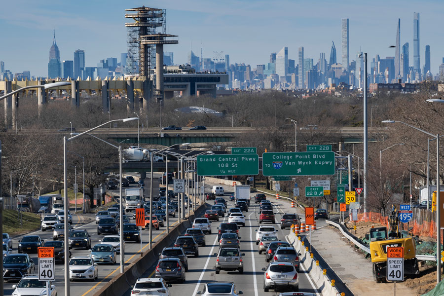
The Long Island Expressway, commonly called the LIE, is the main east–west highway serving Long Island. Officially designated Interstate 495, it runs about 71 miles from the Long Island City side of the Queens–Midtown Tunnel connection across Queens, Nassau County, and Suffolk County to the Riverhead area. Through the tunnel, it also provides a direct roadway connection with Midtown Manhattan.
Built in stages beginning in the mid-20th century, the LIE played a major role in Long Island’s postwar growth by connecting suburban communities, business districts, and shopping corridors with New York City. Today it remains one of the region’s busiest routes for commuters, freight traffic, and visitors heading toward Long Island’s beaches, North Fork wineries, central Suffolk attractions, and the Hamptons by way of connecting highways.
Route and Significance
- Western connection: Long Island City and the Queens–Midtown Tunnel, with direct access to Midtown Manhattan
- Eastern terminus: Riverhead area, where I-495 ends near NY 25 and CR 58
- Length: Approximately 71 miles
- Counties served: Queens, Nassau, and Suffolk
- Tolls: The expressway itself is generally toll-free, but the Queens–Midtown Tunnel connection is tolled
The LIE is well known for congestion, especially during weekday rush periods and on summer weekends. A reversible HOV lane operates along a long stretch of the route through eastern Queens, Nassau, and Suffolk; eligibility requirements, hours, and enforcement details may change, so drivers should always follow posted signs and check current guidance before traveling.
Because lane configurations, exit ramps, and work zones can change over time, posted roadway signage and live traffic information are more reliable than older printed directions. If you are planning a longer trip east, it is wise to check conditions ahead of time, especially on Fridays, holiday weekends, and Sunday afternoons.
Long Island Expressway Exits
Major Interchanges and Commonly Used Connections
| Connection | Area | Why Travelers Use It |
|---|---|---|
| Queens–Midtown Tunnel | Long Island City / Midtown Manhattan | Main tunnel connection between the LIE corridor and Manhattan; tolls apply at the tunnel. |
| Van Wyck Expressway (I-678) | Queens | Important regional link for JFK Airport connections and travel between central Queens and southern routes. |
| Grand Central Parkway | Queens | Useful for Flushing Meadows–Corona Park, LaGuardia Airport connections, and parkway travel across Queens. |
| Utopia Parkway | Queens | Common exit for eastern Queens neighborhoods and Queens College. |
| Cross Island Parkway | Queens / Nassau border area | Major north–south parkway connection toward the Whitestone and Throgs Neck bridge approaches and the South Shore parkway system. |
| Lakeville Road / Community Drive | New Hyde Park area | Serves the Nassau–Queens border area, nearby offices, shopping, and local medical destinations. |
| Glen Cove Road | Carle Place / Old Westbury / East Hills | Frequently used for central Nassau business districts, shopping areas, and north–south local travel. |
| NY 106 / NY 107 | Jericho / Hicksville | Key central Nassau connection for north–south travel and nearby commercial corridors. |
| NY 110 | Melville / Farmingdale | One of the most heavily used Long Island business-district exits, with links to offices, shopping, and southbound routes. |
| NY 454 Veterans Memorial Highway | Hauppauge / Islandia / Islip area | Important Suffolk connection for central county destinations, offices, and airport-area routes. |
| Nicolls Road (CR 97) | Stony Brook / Brookhaven | Common route for Stony Brook University, research campuses, and North Shore/South Shore cross-island travel. |
| William Floyd Parkway (CR 46) | Shirley / Mastic / Brookhaven area | Used for South Shore beaches, Brookhaven destinations, and eastbound travel beyond central Suffolk. |
| NY 25 / CR 58 | Riverhead | Marks the eastern end of I-495 and the transition point for travel deeper into the East End and North Fork. |
Travel Tips
- Expect the heaviest traffic on weekday mornings and evenings, as well as Friday eastbound and Sunday westbound summer travel periods.
- There are no traditional full-service travel plazas on the expressway itself, so drivers typically need to exit for fuel, food, or rest stops.
- HOV rules, lane hours, and enforcement practices may change; always follow overhead signs and current posted restrictions.
- Construction, crashes, and weather can affect travel times in any season, so it helps to check live conditions before a trip.
- If you are connecting through Manhattan, remember that tunnel tolls, closures, and MTA advisories can affect the western end of the route.
Notable Facts
- The LIE is sometimes nicknamed “the world’s longest parking lot,” a tongue-in-cheek reference to its frequent traffic delays.
- The highway was a major part of the mid-century regional road-building era associated with Robert Moses and Long Island’s suburban expansion.
- For many visitors, it is the primary driving route toward central Suffolk, the North Fork, and East End destinations reached by connecting roads.
- Even when traffic is moving well, trip times can change quickly, so local drivers often treat departure timing as seriously as route choice.
Official Resources
For current roadway conditions, incidents, and travel advisories, check 511NY. For statewide transportation information and project updates, visit the New York State Department of Transportation. If your trip involves the tunnel connection to Manhattan, see the latest notices from MTA Bridges and Tunnels. As always, service details may change, so check ahead before driving.
Are you ready for fall on Long Island? Check out these local seasonal guides:
🍎 Apple Picking 🍓 Strawberry Picking 🎃 Pumpkin Picking 👻 Haunted Houses 🍂 Farm Festivals
