
Bethpage State Parkway
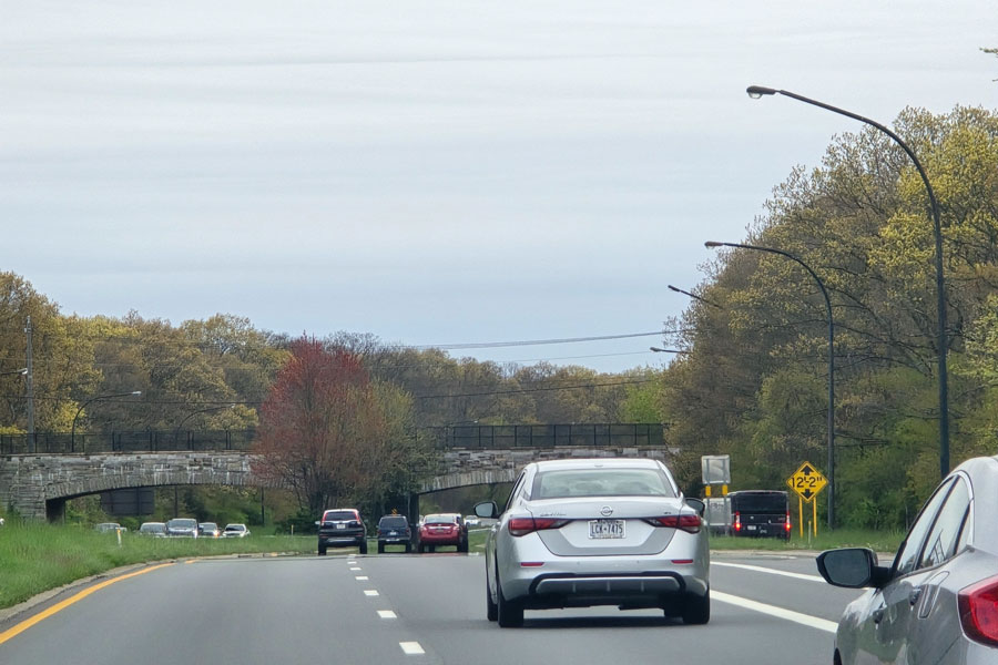
The Bethpage State Parkway is a short north-south parkway in Nassau County linking the Southern State Parkway with Bethpage State Park. Beginning in North Massapequa near the Massapequa Preserve, it heads north through a wooded corridor as a narrow, landscaped limited-access road. The route is especially notable for its quiet setting and its direct connection into one of Long Island’s signature state parks.
Signed exits on the parkway use a B-prefix. The first intermediate access point is Boundary Avenue (northbound only). Farther north, the parkway briefly widens near exit B3 for NY 24, Hempstead Turnpike, where the interchange operates as a partial cloverleaf arrangement. Northbound access here uses a short local connection via Beach Street.
After passing beneath the Long Island Rail Road Main Line, the parkway reaches exit B4 at Central Avenue in Bethpage. It then enters Bethpage State Park, curves northeast, and ends at the traffic circle connecting to Plainview Road and internal park roads. From that circle, drivers can continue toward the park’s golf, trail, picnic, and other recreation areas. Traffic flow inside the park may vary during tournaments, major events, and peak seasonal periods, so it is wise to check ahead before visiting.
A multi-use trail associated with the parkway and the broader Bethpage Bikeway corridor closely follows the route for much of its length, linking Bethpage State Park with the Massapequa Preserve and connections farther south toward Merrick Road. Depending on the segment, the path runs directly beside the roadway or through adjacent preserve land. Trail surfaces, signed access points, and seasonal conditions can vary, so cyclists and walkers should check ahead before setting out.
History
- The Bethpage State Parkway was planned during the Robert Moses era as part of the broader Long Island parkway system, intended to give motorists scenic access to major parks away from the South Shore.
- Construction began in the mid-1930s on land tied to what was already becoming Bethpage State Park, and the roadway opened in 1936.
- From the beginning, the route was designed more as a recreational park approach than as a major through-highway, with commercial vehicles excluded and the roadway set within a landscaped corridor with parkway-style bridges and embankments.
- Over time, planners studied possible southward and northward extensions, including concepts tying the route more directly to other major roads and future parkways. Those larger roadway extensions were never built.
- Later decades brought increased emphasis on bicycle and trail use along parts of the corridor and along nearby rights-of-way once associated with unbuilt expansion plans.
- Today, the parkway remains a compact but distinctive survivor of Long Island’s original state parkway design philosophy.
Shared-Use Path / Bikeway
The multi-use path associated with the Bethpage State Parkway provides one of the more appealing north-south recreational corridors in central Nassau County. It links Bethpage State Park with the Massapequa Preserve and, by extension, with longer trail connections heading south toward Merrick Road.
This path also relates to the broader Bethpage Bikeway system, a longer signed trail corridor extending beyond the parkway itself. Exact mileage, segment names, and routing details may vary depending on the map source or jurisdiction, but the corridor remains a popular option for biking, jogging, and walking. Conditions, detours, and access points can change, especially after weather events or maintenance work.
Future / Unbuilt Extensions
- For many years, planners discussed extending the Bethpage State Parkway north of its present traffic-circle terminus toward major east-west roads and parkways in the Plainview-Woodbury area.
- Some concepts envisioned new interchanges with roads such as NY 135, Old Country Road, the Long Island Expressway, and the Northern State Parkway, along with removal or replacement of the terminal traffic circle.
- Those roadway plans did not move forward, largely because of cost, environmental concerns, community impacts, and changing transportation priorities.
- In practice, later attention shifted more toward trail and greenway use along portions of the reserved or formerly proposed corridor rather than toward building a full parkway extension.
Additional Notes & References
- Like other Long Island parkways, the Bethpage State Parkway is not open to commercial vehicles.
- At roughly 2.5 miles long, it is a short route, but it remains an important direct approach to Bethpage State Park from the Southern State Parkway.
- Its wooded setting, modest scale, and park-oriented design reflect the original Long Island parkway concept of combining transportation with scenic recreation access.
- Road configurations, trail conditions, and park access details may change over time, especially during special events or maintenance projects, so checking ahead is recommended.
Bethpage State Parkway Exits
Exit List
| Exit | Location / Road | Notes |
|---|---|---|
| B1 | Southern State Parkway (North Massapequa) | Trumpet interchange; southern terminus of the parkway |
| B2 | Boundary Avenue | Northbound exit only |
| B3 | NY 24 (Hempstead Turnpike) | Partial cloverleaf interchange; northbound access uses Beach Street |
| B4 | Central Avenue | Access to Bethpage and nearby local streets |
| — | Bethpage State Park / Plainview Road traffic circle | Northern terminus; connects with park roads and Plainview Road |
Although short in length, the Bethpage State Parkway remains an important part of Long Island’s historic parkway network and continues to serve as a scenic gateway to Bethpage State Park. Its wooded corridor, limited-access design, and direct connection to one of the region’s most popular recreational destinations reflect the vision of the early parkway era, when roads were designed to enhance the journey as much as the destination. Whether used by golfers heading to the renowned Bethpage golf courses, cyclists exploring the nearby bikeway system, or visitors enjoying the park’s trails and open spaces, the parkway remains a small but distinctive piece of Long Island transportation history.
Are you ready for fall on Long Island? Check out these local seasonal guides:
🍎 Apple Picking | 🍂 Fall Festivals & Farm Activities | 👻 Haunted Houses | 🎃 Pumpkin Picking
