
Throgs Neck Bridge
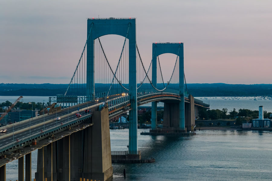
The Throgs Neck Bridge is one of the easternmost major crossings between Queens and the Bronx, serving as a key route for travelers heading between Long Island, New York City, and the Northeast. Opened in 1961, this suspension bridge carries Interstate 295 across the waterway at the western edge of the Long Island Sound, linking Bayside in Queens with the Throggs Neck section of the Bronx. Operated by MTA Bridges and Tunnels, it remains an important route for commuters, commercial traffic, and road trips toward New England.
History
- Planning & Construction: The bridge was built to help relieve congestion on the nearby Bronx–Whitestone Bridge. Construction began in the late 1950s and was completed in under four years.
- Opening: Dedicated on January 11, 1961, the bridge takes its name from the Throggs Neck peninsula in the Bronx. The bridge’s official name has long used the spelling “Throgs,” while the neighborhood is commonly spelled “Throggs Neck.”
- Modern Use: The crossing continues to handle heavy daily traffic. Travel times can vary widely during rush hours, weekends, and holiday getaway periods.
Design & Features
- Bridge Type: Suspension bridge with a main span of 1,800 feet.
- Suspended Length: About 2,910 feet for the main suspended structure, with longer approach roadways on either side.
- Roadway: Six traffic lanes, typically three in each direction.
- Tolling: Cashless, with tolls collected via E-ZPass or Tolls by Mail. Rates and policies may change over time.
- Role in the Network: The bridge forms part of Interstate 295, making it a major connector between eastern Queens, the Bronx, and interstate routes beyond the city.
Importance for Long Island Travelers
For many travelers leaving Long Island, the Throgs Neck Bridge is a practical route toward the mainland and points north. By connecting Queens to the Bronx via I-295, it provides:
- Access to I-95 and the New England corridor – useful for trips toward Connecticut, Rhode Island, Massachusetts, and beyond.
- Connections to major Bronx expressways – including links toward the Cross Bronx Expressway, Bruckner Expressway, and other regional routes.
- An alternative to the Bronx–Whitestone Bridge – route choice often depends on destination, current traffic, and roadway conditions.
For many Long Islanders, the Throgs Neck is a familiar route for trips to Westchester, upstate New York, and New England. Traffic can build quickly around commuter peaks, summer weekends, and holiday travel periods, so checking live conditions before departure is a good idea.
Nearby Landmarks
- Queens Side: Bayside, Little Neck Bay, and Fort Totten Park, a former military site that now serves as a public waterfront park and recreation area.
- Bronx Side: The Throggs Neck neighborhood and nearby Ferry Point Park, known for wide views of both the Throgs Neck and Whitestone Bridges.
There is no place to stop on the bridge itself for sightseeing, so nearby parks and waterfront areas are the best spots for views and photos.
Q&A – Throgs Neck Bridge
Q: Why is it called the Throgs Neck Bridge?
A: The bridge is named for the Throggs Neck peninsula in the Bronx. The bridge name traditionally uses the spelling “Throgs,” while the neighborhood is commonly spelled “Throggs Neck.”
Q: What highways connect to the bridge?
A: On the Queens side, the bridge connects with the Clearview Expressway (I-295). On the Bronx side, it feeds into I-295, with onward connections to I-95, the Cross Bronx Expressway, the Bruckner Expressway, and other regional routes.
Q: How does the Throgs Neck differ from the Bronx–Whitestone Bridge?
A: Both bridges connect Queens and the Bronx, but the Throgs Neck sits farther east and offers a different set of highway approaches. Depending on traffic and destination, one crossing may be more convenient than the other.
Q: Can pedestrians or bicycles use the Throgs Neck Bridge?
A: No. The bridge does not provide pedestrian or bicycle access.
Q: Does the bridge still take cash tolls?
A: No. Toll collection is cashless, using E-ZPass and Tolls by Mail. Check current toll information before traveling.
Vicinity of the Bridge
Area Snapshot
| Feature | Details |
|---|---|
| Opened | 1961 |
| Bridge Type | Suspension |
| Main Span | 1,800 feet |
| Suspended Length | About 2,910 feet |
| Lanes | 6 |
| Toll Collection | Cashless (E-ZPass and Tolls by Mail) |
| Operator | MTA Bridges & Tunnels |
| Primary Connection | Bayside, Queens (I-295) ↔ Throggs Neck, Bronx (I-295 with access to I-95 and other major expressways) |
For more than six decades, the Throgs Neck Bridge has served as an essential transportation link between Long Island and the rest of the Northeast. Its strategic location near the entrance to the Long Island Sound helps make it a frequent choice for commuters, freight traffic, and longer regional trips. Because tolling, traffic patterns, and roadway work can change, it is always smart to check current conditions before heading out.
