
Long Island Expressway (I-495)
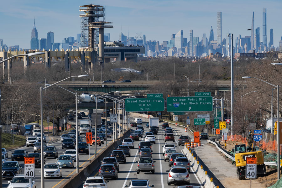
The Long Island Expressway (commonly referred to as the LIE) is the major east–west artery across Long Island, stretching approximately 71 miles from the Queens–Midtown Tunnel in Manhattan through Queens and Nassau County, and continuing all the way to Riverhead in Suffolk County. Officially designated as Interstate 495, the expressway is often called the “backbone” of Long Island’s transportation system.
Built beginning in the late 1940s and completed in phases through the 1970s, the LIE transformed Long Island’s growth, connecting suburban communities to New York City. Today, it remains one of the busiest highways in the region, serving commuters, commercial traffic, and travelers heading east toward Long Island’s beaches, wineries, and the Hamptons.
Route and Significance
- Western Terminus: Queens–Midtown Tunnel, Manhattan
- Eastern Terminus: Old Country Road (NY 25) in Riverhead
- Length: 71 miles
- Counties Served: Queens, Nassau, Suffolk
The LIE is known for heavy congestion, especially during rush hours, and has long been a symbol of suburban commuting culture. It features a High Occupancy Vehicle (HOV) lane in Nassau and Suffolk designed to ease congestion and encourage carpooling.
Exit List – Interstate 495 (Long Island Expressway)
| Exit | Destination / Roadway | Notes |
|---|---|---|
| 1 | East 37th St / Queens–Midtown Tunnel | Manhattan entrance |
| 2 | Borden Ave | Queens |
| 3 | Greenpoint Ave | Long Island City |
| 4 | Grand Ave | Maspeth |
| 5 | Maurice Ave | Maspeth |
| 6 | Laurel Hill Blvd / 48th St | Sunnyside |
| 7 | Woodside Ave | Woodside |
| 8 | Junction Blvd | Corona |
| 9 | Woodhaven Blvd | Rego Park |
| 10 | Queens Blvd / NY-25 | Elmhurst |
| 11 | 108th St | Forest Hills |
| 12 | Kissena Blvd / College Point Blvd | Flushing / Queens College |
| Note: After Exit 12, I-495 continues east and is traditionally known as the Long Island Expressway (LIE) through Nassau and Suffolk Counties. | ||
| 13 | Greenpoint Ave / Van Dam St | Queens |
| 15 | Van Wyck Expwy (I-678) | Access to JFK Airport |
| 18 | Maurice Ave | Maspeth |
| 22A | Grand Central Pkwy | Flushing Meadows–Corona Park |
| 25 | Utopia Pkwy | Queens College |
| 31 | Cross Island Pkwy | Access to Bronx / Whitestone |
| 33 | Lakeville Rd / Community Dr | Nassau border |
| 34 | New Hyde Park Rd | Nassau County |
| 39 | Glen Cove Rd | Carle Place / East Hills |
| 41 | NY-106/107 | Jericho / Hicksville |
| 46 | Sunnyside Blvd | Plainview |
| 49 | NY-110 | Melville / Farmingdale |
| 53 | Commack Rd | Commack |
| 57 | Veterans Memorial Hwy (NY-454) | Hauppauge / Islip |
| 62 | Nicolls Rd (CR-97) | Stony Brook Univ. |
| 64 | HOV Transition / Medford | Suffolk |
| 68 | William Floyd Pkwy (CR-46) | Shirley / Mastic |
| 73 | NY-25 (Old Country Rd) | Riverhead – Eastern Terminus |
Notable Facts
- Nickname: “The World’s Longest Parking Lot” (due to frequent traffic jams).
- The LIE was part of Robert Moses’ vision for Long Island’s post-war development.
- Serves as the main route for travelers heading to the Hamptons during summer.
- HOV lanes run between Exits 32 (Little Neck Parkway) and 64 (Medford).
