
Throgs Neck Bridge
The Throgs Neck Bridge is one of the easternmost crossings that links Queens to the Bronx, serving as a vital gateway from Long Island to the northeastern United States. Opened in 1961, this suspension bridge carries Interstate 295 across the East River at the point where it meets the Long Island Sound. Operated by MTA Bridges and Tunnels, the Throgs Neck Bridge is heavily used by commuters, truckers, and travelers heading toward New England and beyond.
History
- Planning & Construction: The bridge was built to relieve congestion on the Bronx–Whitestone Bridge, located just two miles to the west. Construction began in the late 1950s and was completed in less than four years.
- Opening: Dedicated on January 11, 1961, the Throgs Neck Bridge was named after the Throggs Neck peninsula in the Bronx, though the official spelling of the bridge omits the extra “g.”
- Modern Use: Today, it continues to handle high traffic volumes, with more than 100,000 vehicles crossing daily.
Design & Features
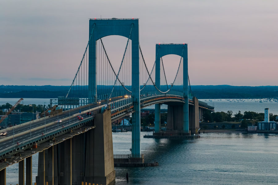
- Bridge Type: Suspension bridge with a main span of 1,800 feet.
- Total Length: Approximately 2,910 feet (0.55 miles).
- Height: Towers rise 215 feet above the water.
- Roadway: Six lanes of traffic, three in each direction.
- Tolling: Cashless, with all tolls collected via E-ZPass or Tolls by Mail.
Importance for Long Island Travelers
The Throgs Neck Bridge is one of the most important links for travelers leaving Long Island and heading north. By directly connecting Queens to the Bronx, it provides:
- Access to I-95 (New England Thruway) – for routes toward Connecticut, Rhode Island, Massachusetts, and beyond.
- Access to the Cross Bronx Expressway – a major east–west artery through the Bronx.
- Reduced Congestion – serves as an alternative to the Bronx–Whitestone Bridge, especially during peak traffic hours.
For many Long Islanders, the Throgs Neck is the preferred route for trips to upstate New York, New England, or points north of the city.
Nearby Landmarks
- Queens Side: Bayside, Little Neck Bay, and Fort Totten Park, a former U.S. Army installation now open as a recreational space.
- Bronx Side: The Throggs Neck neighborhood and nearby Ferry Point Park, with views of both the Throgs Neck and Whitestone Bridges.
Q&A – Throgs Neck Bridge
Q: Why is it called the Throgs Neck Bridge?
A: The bridge is named after the Throggs Neck peninsula in the Bronx. The official spelling drops the second “g” for simplicity.
Q: What highways connect to the bridge?
A: On the Queens side, the bridge connects to the Clearview Expressway (I-295). On the Bronx side, it links to the Cross Bronx Expressway (I-95).
Q: How does the Throgs Neck differ from the Bronx–Whitestone Bridge?
A: While both bridges connect Queens and the Bronx, the Throgs Neck was built later, is slightly longer, and is designed to handle more truck traffic.
Q: Can pedestrians or bicycles use the Throgs Neck Bridge?
A: No, the bridge is closed to pedestrians and cyclists.
Area Snapshot
| Feature | Details |
|---|---|
| Opened | 1961 |
| Bridge Type | Suspension |
| Main Span | 1,800 feet |
| Total Length | 2,910 feet |
| Lanes | 6 (3 each direction) |
| Operator | MTA Bridges & Tunnels |
| Primary Connection | Queens (Clearview Expressway) ↔ Bronx (Cross Bronx Expressway / I-95) |
For over six decades, the Throgs Neck Bridge has provided an essential link between Long Island and the rest of the Northeast. Its strategic location at the mouth of the East River makes it a natural gateway to New England and beyond. Whether for daily commutes, long-haul trucking, or weekend travel, the bridge remains one of New York City’s most important transportation routes.
