
Brooklyn Bridge
The Brooklyn Bridge links Lower Manhattan with Downtown Brooklyn over the East River. When it opened on May 24, 1883, it was the world’s longest suspension bridge and the first permanent crossing of the East River. Today it remains toll-free and is one of New York City’s signature walks, known for its landmark granite towers, sweeping harbor views, and elevated pedestrian promenade.
History
- Conceived by engineer John A. Roebling; after his death, his son Washington Roebling led construction, while Emily Warren Roebling famously took on a major field and communications role during the project.
- Opened to massive celebration on May 24, 1883; dignitaries included U.S. President Chester A. Arthur and New York Governor Grover Cleveland.
- Designated a National Historic Landmark in 1964 and a New York City Landmark in 1967.
Design & Features
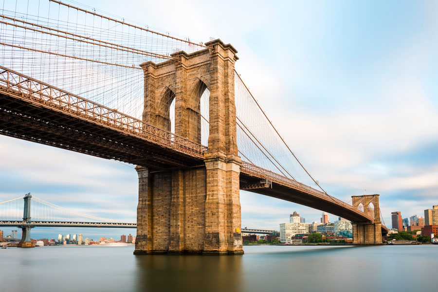
- Type: hybrid cable-stayed/suspension bridge with neo-Gothic stone towers.
- Main span: 1,595.5 ft; total length: about 6,016 ft (roughly 1.1 miles); clearance: about 127 ft above mean high water.
- Traffic: motor vehicle traffic uses the roadway; trucks are generally prohibited.
- Walk/Bike: the elevated promenade is for pedestrians, while cyclists use the protected two-way bike lane on the roadway.
- Toll: Free to cross the bridge itself.
Why it matters for Long Island travelers
Brooklyn occupies the western end of Long Island. For Long Island travelers already heading through Brooklyn, the Brooklyn Bridge offers a classic, toll-free connection into Lower Manhattan, with convenient access to City Hall, the Financial District, nearby subway lines, and one of the city’s best-known skyline walks.
Nearby Landmarks
- Brooklyn Bridge Park for piers, lawns, playgrounds, and waterfront paths in Brooklyn Heights and DUMBO
- DUMBO for cobblestone streets, photo spots, waterfront views, and easy access to the Brooklyn landing
- South Street Seaport and Pier 17 for historic ships, dining, and East River views
- City Hall Park, One World Observatory, and the 9/11 Memorial & Museum for nearby Lower Manhattan sightseeing
The Brooklyn Bridge
Quick Facts
| Crosses | East River |
| Connects | Manhattan (Civic Center/City Hall area) ↔ Brooklyn (Downtown Brooklyn/DUMBO vicinity) |
| Opened | May 24, 1883 |
| Design | Hybrid cable-stayed/suspension bridge with neo-Gothic stone towers |
| Main span / Total length | 1,595.5 ft / about 6,016 ft (about 1.1 mi) |
| Clearance | About 127 ft above mean high water |
| Walk & bike access | Pedestrian promenade plus a separate protected two-way bike lane; access points and routing may shift during maintenance or city work |
| Vehicle restrictions | No toll; trucks are generally prohibited |
| Best times to visit | Early morning and near sunset are especially scenic; expect heavier crowds on pleasant weekends and holidays |
Key facts compiled from public historical and municipal sources; access, traffic patterns, and nearby transit service can change, so check ahead before visiting.
Q&A – Brooklyn Bridge
Q: How long is the walk?
A: The crossing is about 1.1 miles end to end. Many visitors allow 25 to 45 minutes one way, depending on crowds, weather, and photo stops.
Q: Is it open 24/7?
A: The bridge is generally accessible around the clock, though occasional closures, maintenance work, or security restrictions can affect access.
Q: Do I pay a toll?
A: No. There is no toll for pedestrians, cyclists, or standard motor vehicles using the bridge itself.
Q: Are trucks allowed?
A: No. Trucks are generally prohibited on the Brooklyn Bridge.
Q: Where are the nearest subways?
A: On the Manhattan side, nearby stations include Brooklyn Bridge–City Hall (4/5/6), Chambers Street (J/Z), and City Hall (R). On the Brooklyn side, nearby options include High Street–Brooklyn Bridge (A/C), York Street (F), and Clark Street (2/3). Service details may change, so check current MTA schedules.
Q: Can I bike on the promenade?
A: No. The elevated promenade is for pedestrians. Cyclists should use the separate protected bike lane on the roadway.
Q: Where do you enter the bridge?
A: Common pedestrian access points are near City Hall/Park Row in Manhattan and around Cadman Plaza East and Tillary Street in Brooklyn. Signage and approach routes can change during construction projects, so follow posted directions when you arrive.
